
Maritime services at the Antarctic Peninsula

On their journeys through areas with large layers of sea ice even vessels of high ice class or icebreakers could get into trouble. Reliable information from earth orbiting satellites could therefore be highly desirable. The German satellites TerraSAR-X (TSX) and TanDEM-X (TDX) are capable to deliver precise information about the ice cover, independent of the time of day and cloud coverage.
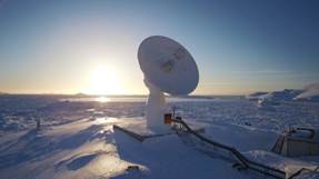
The German Antarctic Receiving Station GARS O’Higgins of the German Aerospace Center (DLR) is now equipped with near-real time (NRT) processing capability for the TSX/TDX data. Thus, the overall TSX/TDX ground segment provides navigation guidance in NRT to research vessels in the Antarctic. The implementation is done in close cooperation with the TSX/TDX ground segment and the Maritime Safety Research Departments in Neustrelitz (DLR-DFD) and Bremen (DLR-IMF).
By providing information products from synthetic aperture radar (SAR) acquisitions, DLR supports a crew to safely navigate through ice. To accomplish this, the ship transmits its position to DLR in Oberpfaffenhofen, which then instructs the two satellites to acquire images of the relevant region roughly 24 hours later. The TSX/TDX data is received at the GARS O’Higgins station directly after the acquisition and is locally processed in near-real time. Subsequently, just one hour after the raw data is acquired from the satellite, the TSX/TDX information product is transferred via email from GARS O’Higgins to the ship. Such a product is generated up to twice a day.
NRT processing at GARS O’Higgins for the Antarctic has been routinely carried out since the beginning of the year. First test campaigns in January/February 2016 were performed successfully.
The German research vessel Polarstern of the Alfred Wegener Institute Helmholtz Centre for polar and marine research (AWI) was supported by DLR during its Expedition PS 96 to the Weddell Sea, Antarctica. The main objective of the planned extensive support of SAR images of sea ice was to support Polarstern navigating through the heavy ice fields in the Weddell Sea, and thus give the possibility for an improved route planning throughout the expedition. In addition, the data were used by different working groups on board to plan the exact position of biological, geological and oceanographic stations dependent on the current ice situation.
Further test and validation campaigns are planned for the coming Antarctic summer seasons. In the future, additional NRT processing will be implemented at DLR‘s GARS O’Higgins station for such worldwide applications as the monitoring of glaciers and shelf ice regions in the Antarctic.