
HANSA
Retrospective Analysis of Historical AIS Data for Navigational Safety through Recommended Routes

Motivation
Especially in times of constantly increasing and developing traffic volumes at sea, a primary goal in the shipping industry is the safe and efficient operation and navigation of vessels. One among other important required regulations for ships is a pre-planned berth-to-berth route which must be prepared by the nautical officer and approved by the captain respectively prior to the ship’s departure. During the route planning process there have been a number of error control features available for both ship and shore-based personnel up to now. Warnings about unsafe water depths or insufficient distances between the ship and shore line are displayed. These functionalities are based on static information only – so far, historic experience and best practices have not been considered. It is desirable to close this gap in the near future.
Objectives and Approaches
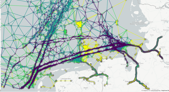
Based on big data analysis, HANSA provides the actors involved with Recommended Routing Corridors - a concept that supports both ship and shore personnel in route planning and monitoring. A Recommended Corridor is the area in which similar vessels have sailed safely through the same waters under similar conditions. Similar vessels incorporate the characteristics of a vessel, e. g. its dimensions and type, while similar conditions refer to meteorological and hydrographic data such as wind, tidal streams and water currents. The core idea of HANSA is to develop these Recommended Corridors from historical vessel traffic data in which the available meteorological and hydrographic information is embedded.
Mariners on board will have an additional method of cross-checking at their disposal to re-confirm correct and safe route-planning. They will also benefit from the nautical experience of other mariners. The Recommended Corridors displayed will support the mariners’ decision whether to execute their manually pre-planned routes or apply changes for an optimized route. At this point it should be emphasized that HANSA is a supporting tool for the mariners but the decision on the executed route remains with them. Vessel Traffic Service (VTS) and Coastal Surveillance System (CSS) operators ashore can experience an improved way of monitoring, assessing, and evaluating entire traffic-related situations in their designated area of responsibility, and consequently act accordingly. In this context, HANSA offers a first step towards autonomous anomaly detection when monitoring vessel traffic. Anomalies are indicated, for example, when ships leave a Recommended Corridor or when they are slower than most of the other vessels within this corridor. In addition to the supporting assistance feature for route planning, the HANSA project is a significant step towards intuitive detection of potential hazardous situations. As a result, incidents with serious consequences are mitigated at an early stage, the overall safety of navigation at sea is improved, and the safety risk for ship crews, vessels, cargo, and the environment is reduced. In relation to ongoing research projects on crew reduction and autonomous vessels, the HANSA project is of particular importance. The integration, implementation and demonstration of the Recommended Routing Corridors has taken place within the e-Maritime Integrated Reference Platform (eMIR) operated by OFFIS, also within the on-board NAVTOR planning station which is used by numerous vessels for passage planning, and within the in-house simulation software inVNE (Virtual Navigation Environment) of in-innovative-navigation GmbH.
Die Betreiber von Vessel Traffic Service (VTS) und Coastal Surveillance System (CSS) an Land können die Verkehrssituation in ihrem Zuständigkeitsbereich besser überwachen, einschätzen und bewerten – und dementsprechend reagieren. In diesem Zusammenhang bietet HANSA einen ersten Schritt zur autonomen Erkennung von Anomalien bei der Überwachung des Schiffsverkehrs. Solche Anomalien werden beispielsweise angezeigt, wenn Schiffe einen empfohlenen Korridor verlassen oder wenn sie sich langsamer als die meisten anderen Schiffe innerhalb dieses Korridors bewegen.
Neben seiner Funktion als Unterstützung für die Routenplanung stellt das HANSA-Projekt einen wichtigen Schritt in Richtung einer intuitiven Erkennung potenzieller Gefahrensituationen dar. Dadurch können Zwischenfälle mit schwerwiegenden Folgen frühzeitig entschärft, die Sicherheit der Schifffahrt auf See insgesamt verbessert und das Risiko für Besatzung, Schiffe, Ladung und Umwelt reduziert werden. Im Zusammenhang mit den laufenden Forschungsprojekten zur Reduzierung der Besatzung und zu autonomen Schiffen gewinnt das HANSA-Projekt zusätzlich an Bedeutung.
Die Integration, Implementierung und Demonstration der empfohlenen Routenkorridore erfolgte im Rahmen der von OFFIS betriebenen e-Maritime Integrated Reference Platform (eMIR), in der bordseitigen Planungsstation NAVTOR, die von zahlreichen Schiffen für die Passageplanung genutzt wird, sowie in der hauseigenen Simulationssoftware inVNE (Virtual Navigation Environment) der in-innovative-navigation GmbH.
Project HANSA - Retrospective Analysis of Historical AIS Data for Navigational Safety through Recommended Routes
- Project duration: 01.06.2018 - 31.05.2020
- Funded by: German Federal Ministry for Economic Affairs and Energy; MarTERA