
40 Years DFD – 40 years of international cooperation
by Gunter Schreier, at DFD since 1985

For more than eight months the whole world has been in the state of emergency that goes by the name of COVID-19. Like most of my DLR colleagues I too am working from home.
Meetings and conferences are being held virtually, if they take place at all. Now that DLR has adapted to Lync and Skype, telephoning from home is just as convenient as from the office, assuming a good internet connection. “Webinars” replace formerly scheduled meetings and conferences. One gathers in cyberspace instead of traveling to partners and colleagues or inviting them to Oberpfaffenhofen. One sits in front of a webcam, casually dressed instead of first fetching one’s best trousers, a jacket, or even maybe a suit from a roller suitcase, smoothing out the wrinkles in the steam from the hotel shower and then – if it’s a meeting at the height of summer and without air conditioning – taking off one’s suit jacket as soon as possible.
In the beginning I was astounded at what internet meeting portals like Zoom, GoToMeeting, and others are able to achieve. I was also astonished at the moving images of colleagues who stayed up until late at night in Japan or got up around 4 am on the US West Coast to make possible a meeting with European colleagues. That’s a beneficial situation for us since it is then around noon in Europe. Meeting virtually also to discuss how we want to organize our contributions at a conference that will now be held in cyberspace – or maybe cancelled until 2021, hoping that things will have returned to normal by then. It often took what seemed like the first 20 minutes of a tele-meeting before everyone was present and connected up properly. But in the meantime months of experience have turned us into experts in all these virtual systems, webcams, chats and microphone-muting functions.
As convenient as this virtual trip around the world may be, this tele-presence at the most distant locations forced on us by the corona virus, I’m not the only one who has the feeling that something is missing. Something substantial.
What’s missing is personal vis-à-vis interaction. The small-talk in between official appointments that provides opportunities to understand the concerns of others, or to bring up ideas for projects and cooperation that at first sound bizarre and outlandish. And above all, international cooperation, the lifeblood of aerospace and satellite earth observation from the very beginning. Cooperation that stimulates earth observation and drives new developments, cooperation not only in the “space segment”, the satellites and sensors, but especially also in the “ground segment”, with its receiving stations, processors, data distribution, and, ultimately, data applications. International cooperation and transnational projects are part of the core business of the German Remote Sensing Data Center. They have accompanied DFD ever since it was founded, and they continue to determine many of its day-to-day activities.
In addition to my other responsibilities, over the years I have grown into the role of something like an EOC foreign affairs official. In 1985 I began working at the WT-DA facility of what was then DFVLR. My job description included the development of a SAR geocoding system for the planned European earth observation satellite ERS-1. Quite soon the small group I was in charge of was confronted with a growing network of national and international partners, with development partners in Hanover, Zurich and Graz, and of course with the contractors for the ERS mission, ESA with its European Space Research Institute (ESRIN) in Frascati near Rome. To this list were added other European institutions that were likewise to set up and later operate “Processing and Archiving Facilities”, so-called PAFs: colleagues in Great Britain, Italy and France.
It’s hard to imagine EOC routine operations without such European projects and collaboration. Third-party financing obtained via Horizon 2020 and ESA are a welcome side effect. But such partnerships primarily bring mutual scientific and technological returns, despite occasionally having to overcome administrative hurdles and acknowledge national idiosyncrasies. Other blogs in this series have already described projects to set up the ground segments and to develop processors and archives for European satellites, right up to the current Copernicus Sentinel satellites. The project leader for the first PAF for ERS-1, my esteemed colleague Jörg Gredel, has much more information and facts on tap than I could ever retrieve from my few records and notes.
So much for my brief and necessarily incomplete review of international contacts, projects and encounters, some of which still shape DFD up to the present.
Jörg Gredel was also the person who approached me shortly after I joined DLR. The then head of the Applied Data Technology facility (WT-DA), Winfried Markwitz, had forwarded to him a letter from Bonn. In 1984 a “Committee on Earth Observation (CEOS)” was started on the sidelines of the G7 summit . The goal was to coordinate national earth observation projects “to optimize societal benefit”. Germany, also a G7 member, was expected to actively participate in CEOS and delegate DFVLR experts to the working groups. Earth observation experience was, after all, available in Oberpfaffenhofen where there was current involvement in this European satellite, ERS-1. There was no need to convince Jörg Gredel of the usefulness of this venture since early in his professional career he had been deputized to JPL in Pasadena for a time and knew how much one could learn from mutual exchanges. In addition, many of the CEOS working groups that had been established were oriented toward data technologies, formatting for data exchange between systems, and that was also a domain of WT-DA, today‘s DFD. A new digital format was required for the geocoded SAR data that ERS-1 was to deliver: internationally harmonized so it could be universally used. He asked me to join the relevant CEOS working group. Meetings were scheduled every six months on the premises of one of the international partners. Originally, CEOS was a club of G7 countries; later, Russia, China and many other countries joined, in some cases as “observers”.

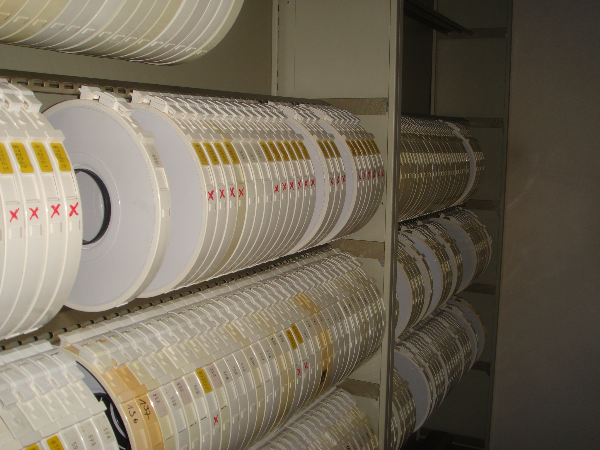
In order to understand the technical challenges of a uniform data format it is first necessary to forget about today’s technology. Until far into the 1990s a format developed by NASA and USGS dominated Landsat mission data. The “data media” for this format were Computer Compatible Tapes (CCTs). Invented by IBM and put on the market in the late 1950s, one of the last-generation that we used of these magnetic tapes could store all of 140 megabytes. Thus the spectral bands of Landsat scenes had to be archived on several of these CCTs, and copies made for sending to users. The readers, technical marvels of the size of an American home refrigerator, cost the equivalent of a semi-detached house. We had several of them since they were essential for data exchange linked to the ERS-1 mission.

For this tape medium and for the new SAR data an internationally standardised data format now had to be found. One of the challenges was the data sequence. It was necessary to tell the reading system in a “record” what it was going to read at what following location. The position and length of each section of the tape that contained metainformation had to be precisely determined. For geocoded data with their varied cartographic systems and geodetic references that were still supported at that time this meant leaving as many bytes as possible free in order to be prepared for any subsequent changes. The technical peculiarities of the IBM format also played a role. Before every image line on the tape there was a 192 byte long information sequence. It contained only a rather small amount of information and ensured that the read/write buffer of the IBM tape reader, which held exactly 192 bytes, was filled for each new image line. That meant that the following image pixels could be read out all the faster – at a 192 byte pace.
This brief excursion into the information-technology “Bronze Age” illustrates to some extent that the challenges differed from today’s, and were more closely related to hardware limitations. Nevertheless, the “CEOS data format” survived up into the 2000s. Today, data are no longer exchanged on computer tapes but via internet platforms, and calculations can often be performed there as well. Without any data transfer.
But – then as now –there were and are, everywhere, the same challenges to bring together the international community. Then it was at international gatherings, instead of today via the Internet and emails.
Already the preparations for such an exchange posed challenges. In addition to using the good old snail mail, agendas were faxed. I remember that the only fax machine in Oberpfaffenhofen was in the administration building. By appointment it was possible to also fax internationally, or pick up an incoming fax printed on thermo-paper that soon lost contrast as it discoloured. If a meeting was then agreed and travel had to be arranged, all inquiries, offers and bookings were handled by the DLR travel office. The ticket arrived in the house mail delivery. It was a bundle of thin sheets with red dye that rubbed off the carbon copies. The printing was so weak on the last sheet in the bundle (the customer’s copy) that the flight destination could barely be deciphered. At many locations the return flight had to be confirmed in a phone call well before the flight. Otherwise one could be left behind in San Francisco, Peking or Sydney. Once underway, communicating home was not easy. There was no internet at DLR until the early 90s, and of course none of the notebooks now seen everywhere, far less any smartphones. Telephone calls made from the hotel room in the morning or evening – depending on the time difference – through an international call-provider with a local phone number were somewhat cheaper. In short, international meetings meant that you were away for a while. The advantage was the possibility to fully concentrate on the subject matter of the meeting and one’s partners there. There was no question yet of processing emails in the hotel room as soon as one got up or before going to bed.
But here, too, the CEOS Working Group on Information Systems and Services (WGISS) brought an innovation. Our US colleagues were experimenting with a precursor version of email exchange (OMNET), and we could take part thanks to our CEOS contacts. Jörg Gredel’s department arranged for some of the DFD staff to use this new form of communication, which was, however, limited to contacts with the few other CEOS users. These included, of course, ESA in Frascati. Gerhard Triebnig, initially head of a working group at Joanneum Research in Graz, took part with us in developing SAR geocoding algorithms and was meanwhile working in Frascati. He was, together with Luigi Fusco – who unfortunately died in 2020 –one of the ESA technology scouts investigating modern communication methods. Shortly after CERN – where Tim Berners Lee invented the HTML protocol and thereby the Web as we know it today –ESRIN operated one of the first servers in Europe as well. DFD was also involved in developments that we shared with our CEOS partners, like our Intelligent Satellite Data Information System (ISIS), supported by a thesaurus to aid in translating colloquial questions into language comprehensible in the metadata world. A forerunner of Alexa, so to speak, but only in writing, and in the testing phase restricted to earth observation concepts. Some of these early innovations did not get beyond the prototype stage, which was also true for many of the products of our international colleagues. That is quite normal. The World Wide Web created at that time was and is still subject to extremely rapid change. Who today remembers the first browsers like Netscape, Mosaic and Mozilla? But our European contacts through ESA projects and our international contacts through CEOS were again and again fruitful for our own information systems, and with a collegial approach we could again and again compare and adapt to how others do things.
As a geophysicist by training, I was of course fascinated by Earth’s topography. For the terrain correction of SAR data we also needed Digital Elevation Models (DEM), which we had to sometimes piece together from information in government ordnance surveys and from other international organisations. Early global and very low-resolution elevation models existed, like manually digitized elevation lines from freely available world maps. Some came from military sources, but were made available to scientists. That general situation prompted us to participate as a matter of course in the CEOS GLOBE (Global Land One Kilometer Elevation) project. A global, freely available topographic model of the entire Earth was a breakthrough at the time. The final product was then distributed by USGS under the name GTOPO-30. Although primarily data from digitized maps were used, in a few places stereo-optically derived elevation data were also incorporated. In February 2000 the Shuttle Radar Topography Mission (SRTM) provided the first quasi-global elevation model (Earth’s high latitudes were not included) based on bistatic SAR data. Again, in international cooperation. NASA/JPL constructed and operated the two C-band antennas, which were separated by a 40 metre long boom. DLR was responsible for the bistatic X-band components. The narrow swath width and limited duration of the mission did not permit a full-coverage model. The data processed at DFD were distributed for the first time over the internet and were in such high demand by international users that internet access sometimes reached its limits.
It took a few years until with TanDEM-X the first high resolution DEM of the entire earth could be produced exclusively with satellite data. But the first attempts in a CEOS context and especially the discussions with our US partners were very fruitful for our work at DFD on global DEM, which continues today in Achim Roth’s working group.
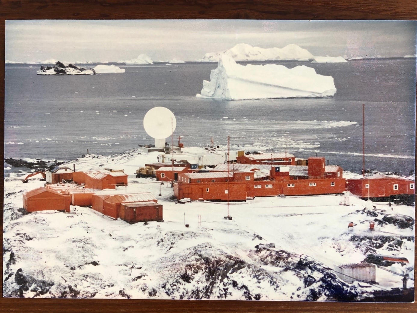
Our receiving stations were and are inevitably international because of the nature of the task they perform. With our antennas we acquire data from the earth observation satellites of our international partners and others, data that not only show Germany or Europe, but areas all over the world. Moreover, our stations are not only found in German locations like Neustrelitz and Oberpfaffenhofen. Because of the geometry of most satellite orbits we also operate stations near the poles, at O’Higgins on the Antarctic Peninsula and in Canada’s high north, in Inuvik. The idea of international station locations was also motivated by ESA’s first ERS mission. The satellite had no recorder on board, so the high-rate SAR data collected had to be promptly transmitted to a ground station in the satellite’s visibility range. That was no problem for Europe, where there were several stations. But recording tropical rain forests or Antarctic ice with the SAR sensor on ERS-1 clearly required receiving stations at those locations. This challenge – also and especially in the international sphere – was first taken up at DFD by Klaus Reiniger and his colleagues. The results were the first X band receiving station on the Antarctic continent, a station in Gabon in Central Africa (which was later erected in Chetumal, Mexico), and transportable stations temporarily set up in Ulaanbaatar, Bishkek and Ny-Alesund on Spitzbergen as well.

I was involved in establishing our latest international station, our large antenna in Inuvik in the Canadian North West Territories (NWT), and was several times at that location. This was driven by the TanDEM-X Mission, which required a data downlink as close as possible to the North Pole to augment our stations in Europe. We considered using existing stations in Alaska, but rejected the idea also because of the incompatibility of US legislation with the new German satellite data security law. So Canada was left, which was moreover an ESA partner state. We had had had good contacts with the Canada Centre for Remote Sensing (CCRS) for many years. CCRS operates the national stations for Canada’s Radarsat mission and was also investigating options for a station in the high north. But at the time there was neither a concrete mandate nor a budget. Canada was also well aware of the logistic and administrative hurdles that would accompany such a station. When Erhard Diedrich, Klaus Reiniger’s successor, and I went to see Stuart Salter, the director of CCRS, he wished us much success and assured us of support. But at the same time he doubted whether his German colleagues would manage to accomplish the task within the envisioned timetable. After considering all the options it was relatively soon clear that Inuvik, Canada’s largest city north of the polar circle, would be our location of choice. It could be reached year round via Dempster Highway and there were daily scheduled flights to Mike Zubko Airport near Inuvik. Tom Zubko, the son of the man after whom the airport was named and a former bush pilot, was our local contact. At minus 30 degrees Celsius we investigated suitable locations for our station by helicopter and snowmobile. Each of us drove his own snowmobile, which I had never done before. When the toes of my right foot became numb Tom terminated our search and I had to warm up at the oven in his home. Tom had sharply admonished us that trying to play the hero here could have a bad ending, in the best case, frostbitten toes. International engagement at DFD not only means sitting in air-conditioned meeting rooms, but also putting one’s total physical effort into measurement campaigns in the field looking after our stations, exposed to the adversities of wind and weather. Whether in icy cold or tropicaI heat. I don’t personally experience much of this, but that gives me all the more reason to pay high tribute to my colleagues who do.

In the end, we built the station on Canadian government property. Stuart Salter recognized the advantages of stations in Inuvik and assumed the role of facilitator for Canada’s Inuvik Satellite Station Facility (ISSF). After he retired from CCRS he was actively engaged in getting the NWT government to lay a glass fibre cable across the Canadian tundra to Inuvik. Once again, something new and a logistic challenge. In the meantime several international partners in Inuvik have their own local antennas. Inuvik is a routine consideration when planning international satellite missions, also for the Copernicus Sentinels. In June 2020 we wanted to celebrate our ten-year presence in Inuvik. The invitations had already been sent. Then corona intervened. The celebration is for the time being postponed until next year. But contacts continue with our international partners, even if we now meet almost exclusively in the digital realm. At the same physical distance and digital vicinity as we communicate with our own colleagues who are actually in a nearby office.
Addendum on 11 November 2020
While we are still in a partial lockdown and asked to work from home wherever possible, the work continues at DFD’s international locations, especially at the receiving stations. Our colleague Ruslan Artemenko has just completed his corona quarantine in a hotel in Punta Arenas and will soon be setting off by ship for the Antarctic. Urgent tasks await him at our O’Higgins station.