DLR cooperates with ESA implementing standardized OGC interfaces to serve GMES users with TerraSAR-X and IRS data

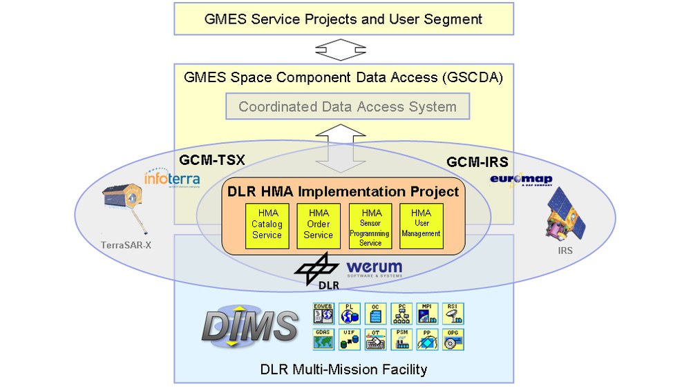
DLR’s Data and Information Management System (DIMS) will be upgraded this year with standard OGC (Open Geospatial Consortium) interfaces serving TerraSAR-X and IRS (Indian Remote Sensing satellite) data to the GMES (Global Monitoring for Environment and Security) users.
The European Space Agency (ESA) is promoting OGC’s geospatial interoperability standards in interfaces and encodings for earth observation data services that are essential parts of the Heterogeneous Mission Accessibility (HMA) initiative. HMA enables ESA to serve GMES Service Projects and users with earth observation data of some 40 different satellite missions.
DLR belongs to the first agencies committing to implement all the HMA interfaces. The DLR HMA Implementation project was contracted by ESA to DLR to extend the component based DIMS services with the standardised user service interfaces. The project started May 2009 with Werum Software and Systems AG as a sub-contractor in charge of implementing a fast HMA Catalog Service interface.
DLR serves two GSCDA (GMES Space Component – Data Access) Contributing Missions (GCM) projects through engineering support, by hosting TerraSAR-X and IRS data in DIMS, and by providing the HMA interfaces. The GSCDA projects are funded through the European Community’s Seventh Framework Programme, managed by the European Space Agency.
The GCM-TSX project is led by Infoterra GmbH which commercially distributes data from the German TerraSAR-X remote sensing radar satellite. The GCM-TSX project started with the kick-off in July 2009. TerraSAR-X is operated to acquire data in different imaging modes, which are distinguished by their spatial coverage and resolution:
• SpotLight mode: 10 km x 10 km scenes, 1 m resolution
• StripMap mode: 30 km wide swath of 1,650 km maximum length, 3 m resolution
• ScanSAR mode: 100 km wide swath of 1,650 km maximum length, 16 m resolution
The GCM-IRS project is led by Euromap Satellitendaten-Vertriebsgesellschaft mbH residing in Neustrelitz, Germany. Euromap is the only actor in Europe to successfully receive, archive and market Indian Earth observation satellite data. The products range spans from 2.5 m black & white in flight stereo, over 5 m color, to 20 m, 60 m and 180 m multi-spectral data sets covering Europe and Northern Africa. Imagery of other continents and other types of data can be supplied as well. The GCM-IRS project kick-off took place June 2009.

