On Saturday, Jan. 15, 2022 at 5:15 o’clock Central European Time an enormous explosion caused by the submarine volcano Hunga Tonga Hunga Ha‘apai profoundly shocked the South Pacific island state of Tonga. The detonation could even be heard in New Zealand, over 2,300 kilometres away. In Oberpfaffenhofen, Bavaria, EOC measuring instruments also recorded the volcano’s shock wave, which spread over the entire planet at a velocity of more than 1,000 kilometres per hour. Tidal waves followed, extending as far as the coasts of South America. Research underway at EOC has the goal to provide early warning of tsunami.
For several years, EOC scientists have been developing an innovative tsunami early warning system by exploiting so-called infrasound, which is caused by shock waves of a very low frequency range below 20 Hz. In contrast to audible sound, infrasound spreads out in the atmosphere almost undamped, leaving traces that can be detected by an infrared camera (FAIM) and an infrared spectrometer (GRIPS) developed at DLR. The precondition is a cloud-free view of the mesosphere at an altitude of ca. 80 to 100 kilometres.
The DLR instruments are to be tested this year at the European Southern Observatory in the Atacama Desert as part of the OASIS project. Tsunami warnings are one of the topics under investigation there. If there is a seaquake off the coast of Chile, these instruments can verify within minutes of a seismic alarm signal whether a pressure pulse also arrives in the atmosphere at the edge of outer space. If not, then the ocean floor has only experienced a horizontal mass displacement and there will be no accompanying tsunami.
10.01.2022 - 25.01.2022
Sulphur dioxide cloud from "Hunga Tonga Hunga Ha‘apai"
Your consent to the storage of data ('cookies') is required for the playback of this video on Quickchannel.com. You can view and change your current data storage settings at any time under privacy.
Sulphur dioxide cloud from "Hunga Tonga Hunga Ha‘apai"
Data from the Japanese weather satellite Himawari-8 showing the eruption of the submarine volcano. The shock wave can be seen at lower right (starting at 1:30 pm) and spreading out concentrically over the earth from the site of the eruption. As a result, a tsunami warning was given for some of the Pacific island states, and indeed shortly thereafter a ca. 1.20 m high wave reached Tonga’s capital. Tsunami waves were also registered on the coasts of Peru and Chile.
While preparing for this mission, researchers at Oberpfaffenhofen were just in the process of testing a microbarograph when the massive eruption took place in the South Pacific. This instrument detects the slightest deviation in air pressure at Earth’s surface and is intended to complement the optical measurements of the DLR instruments FAIM and GRIPS in Chile.
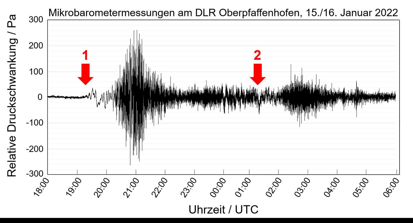
About 15 hours after the volcanic eruption the microbarograph registered the shock wave in Oberpfaffenhofen after it had already travelled almost 17,000 km across Earth’s surface. A second strong signal reached the instrument a few hours later. That was the part of the shock wave that had travelled in the opposite direction on a longer route around the globe to Oberpfaffenhofen. But the microbarograph was not yet finished even then. For hours it continued to register the electromagnetic discharge from the eruption cloud, which covered an area of several hundred thousand square kilometres and extended up to 20 kilometres altitude. Early information sources mention up to 6,000 lightning flashes per minute discharging from this cloud, causing the microbarograph on the other side of the world to react.
Measurements from the infrasound microbarograph in Oberpfaffenhofen.
The main part of the signals in the infrasound range come in each case about an hour after the two passages “1”and “2” of the shock wave. This is due to the complex propagation conditions in the atmosphere. (source: Carsten Schmidt, Leon Knez)
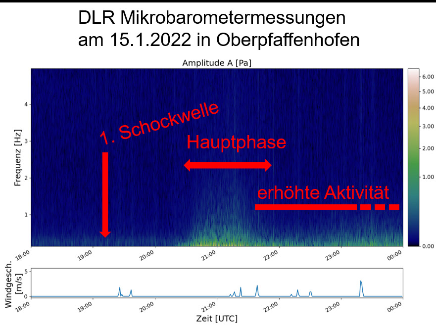
Preliminary frequency analyses of the signal profile show the different phases of volcanic activity in the range of 0.2 Hz to 2 Hz. The clearly distinguishable signals are evidence of the unimaginably strong forces having an effect on the other side of the world. By contrast, the considerably closer Cumbre Vieja volcanic explosion on La Palma, one of the Canary Islands, was hardly noticeable in the measurements.
Frequency analysis during and after the first passage of the shock wave late in the evening of January 15, 2022
The infrasound activity distinctly increased only around 20:30 UTC and then remained significantly high for many hours thereafter. Since at this time it was basically calm in Oberpfaffenhofen (lower diagram), the measurement conditions were close to ideal.
Detailed analysis of the data will take place over the next few weeks in cooperation with Augsburg University. This will involve the use of highly complex HARPA/DLR numerical propagation models, which permits precise allocation of the signals to events at their place of origin. The first results of the calculations, some of which are being carried out by the powerful computer at the Leibniz Supercomputing Centre in Garching, are expected within a few days.
While ground measurements are negatively affected by wind and local events, FAIM and GRIPS in the Chilean desert receive a direct view of the infrasound activity in the atmosphere. In the future, satellites could also carry these instruments and detect comparable events globally. Up to now, tsunami early warning systems have been seismically induced and do not give sufficient warning of tsunami caused by large mass movements, for example. Thus the collapse of a flank of the Indonesian volcano Anak Krakatau on December 22, 2018 triggered a tsunami that caused over 430 deaths. Particularly this volcano-induced danger is being investigated by EOC in another BMBF financed research project, TSUNAMI_RISK.
The tidal wave caused by Hunga Tonga Hunga Ha’apai created havoc especially on Tonga, but it also reached South America. In addition, the EOC crew at DLR’s Antarctic acquisition station GARS O’Higgins and the neighbouring Chilean Antarctic station had to be evacuated since the stations are at a vey low elevation. They waited together for 10 hours in a supply depot that was located on a small hill about 15 metres above sea level.
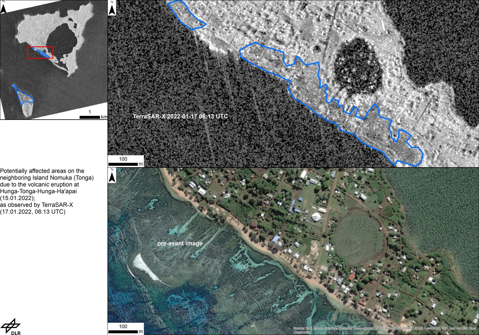
EOC made available images from the German radar satellite TerraSAR-X as part of the International Charter ‘Space and Major Disasters’.
They make it possible to map disaster regions unhindered by clouds. This map, derived from a TerraSAR-X recording on Jan. 17, 2022, show the potential to distinguish locations on the south-western coast of the island of Nomuka affected by tsunami.


