SO2 Monitoring and Volcano Surveillance (EVOSS, SACS und SMASH)


The amount of sulfur dioxide (SO2) in the atmosphere can be determined from the characteristics of the sunlight reflected from the earth’s surface as measured by instruments like GOME-2 on earth observation satellites. Since the only sources for this compound in the atmosphere are volcanic eruptions and human activity, it is an ideal indicator for monitoring and measuring volcanic eruptions as well as air pollution in urban areas.
Volcanic eruptions not only seriously endanger local populations; they can also be a more or less long-term hazard for air traffic. Ash clouds released by volcanic eruptions can damage airplane engines, and the SO2 likewise emitted can be drawn into the cabin, causing respiratory problems. In the atmosphere, SO2 is chemically converted into acid rain, which leads to heightened corrosion of aircraft components. Aircraft operators are accordingly greatly interested in receiving timely information about volcanic eruptions as well as the location of any resulting ash and SO2 clouds so that flight paths can be modified as necessary.
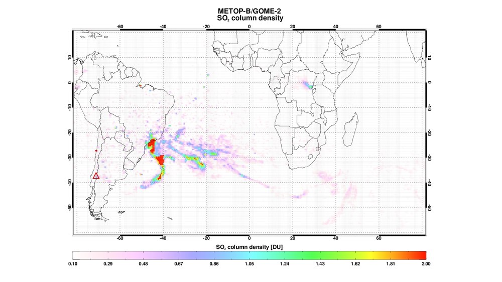
In the context of international projects, the Atmospheric Processors department of DLR’s Remote Sensing Technology Institute provides SO2 density information obtained from GOME-2 measurements on EUMETSAT MetOP satellites for the purpose of continuous volcano monitoring. The satellites provide daily coverage of the entire earth surface at a spatial resolution of 40 x 80 km2. These data can be used to produce global maps showing the distribution of SO2 volcanic clouds:
• SACS (Support to Aviation Control Service) and SMASH (Study on an end-to-end SysteM for volcanic ASH plume monitoring and prediction): These two ESA projects collect from various instruments information and measurements concerning SO2 and aerosol emissions and make them available on line in near real time. The global coverage of satellite-borne sensors makes it possible to detect volcanic eruptions in remote regions. Both projects support the so-called Volcanic Ash Advisory Centers (VAACs), which monitor the occurrence of volcanic ash in the air and inform the aviation sector as needed.
• EVOSS (European Volcano Observatory Space Services): This EU-financed project is a continuation of the SAFER project, which had the goal of long-term volcano monitoring in Europe, Africa and the Antilles. Information is being collected about volcanos and volcanic eruptions and made available online at the so-called “EVOSS Virtual Volcano Observatory”.
