The coherent 2-µm Doppler wind lidar aboard the Falcon F20 research aircraft has been operated for almost two decades and has made significant contributions to numerous national and international field campaigns. Various scientific questions have been addressed. With “Deepwave” and “GW-LCYCLE”, for example, the focus laid on the characterization of the life cycle of atmospheric gravitational waves. The “Saltrace” campaign dealt with questions about the transport of Sahara dust across the Atlantic Ocean and changes in its optical properties during this transport. Wind measurements in general had the aim of demonstrating the potential of improving weather forecast by wind profiles obtained from airborne Doppler lidar. Finally, in recent years, the focus has been the validation of the first wind lidar in space, the Aeolus satellite. In the meantime, the 2-µm lidar is established even internationally as a standard for the detection of wind and turbulence as well as wake vortex measurements.
Measurement principle: A coherent Doppler lidar emits short laser pulses and detects the radiation backscattered by aerosols through optical heterodyning. This allows both the determination of the intensity of the backscattered radiation and its Doppler shift in line-of-sight (LOS) direction. The three-dimensional wind vector can be calculated from different observation directions of a conical scan. Various algorithms are available for this procedure and are constantly refined and adapted to respective scientific question (see figure). The great advantage of this measurement principle is that the Doppler shift of the narrow-band backscatter signal can be detected with high accuracy, considering that enough aerosol particles as for instance water droplets or dust particles are present.
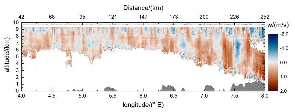
Atmospheric gravity waves are for example excited by flow over mountains and can propagate into the mesosphere at altitudes as high as 100 km. In order to record the vertical speed with high resolution, it is necessary to point the laser beam exactly vertically downwards. Changes in the aircraft position (roll and pitch) are automatically compensated by the lidar scanner during these measurements.
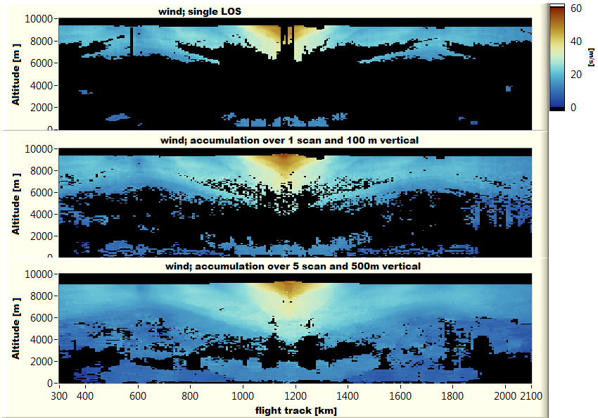
Over the years, the 2-µm Doppler lidar and the used evaluation algorithms used have been continuously improved. This is revealed by the figure shown below. While only a part of the atmosphere is sampled by conventional processing based on line of sight estimates (top and middle) an almost complete coverage can be achieved with spectral accumulation over 5 scans (bottom). For the validation activities of Aeolus in particular, the accumulation of five scans resulted in 56% more data points to be used for comparison with Aeolus data, compared to the accumulation with one scan.
Example for atmospheric gravity waves. The inflow is from the west (left). The "breaking" of the longer waves at the tropopause is very nice to be seen at an altitude of 8 - 8.5 km.
Example of improved coverage through the use of accumulation technology. The plot shows a flight south of Iceland, September 2019: Wind calculated from single LOS estimates (top). Use of the accumulation technology over 100 m vertical range and a conical scan (middle). Accumulation technology over 5 scans and 500 m vertical range (bottom).