
Passive remote sensing
Satellite or ground based passive remote sensing from satellite utilize either solar radiation reflected at the Earth's surface or scattered in the atmosphere, or thermal

radiation emitted by the surface-atmosphere system. At the Institute of Atmospheric Physics our remote sensing activities especially focus on water and ice clouds as well as on contrails and aerosols (also volcanic ash). Aim is to better understand life cycle processes and the effect of clouds and aerosols on weather, climate, and chemistry. Regarding remote sensing of volcanic ash it is envisaged to provide a contribution to an efficient air traffic management.
Clouds
Various passive remote sensing algorithms have been developed that allow for the detection of water and ice clouds as well as for the retrieval of their microphysical, macroscopic and optical parameters.
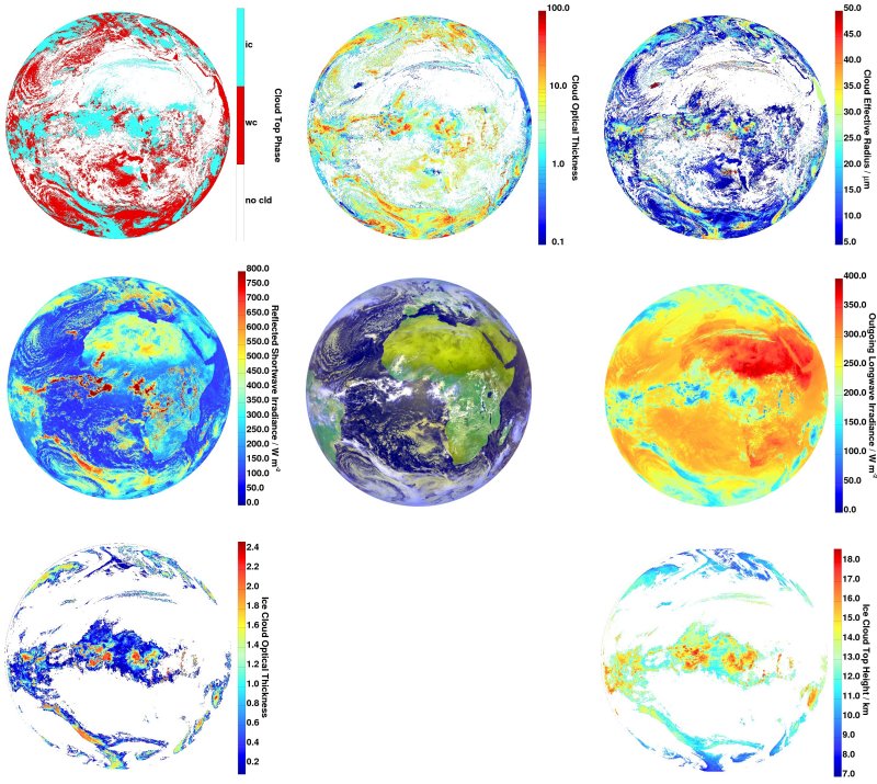
For the detection of clouds channels in the thermal infrared of the SEVIRI instrument aboard the geostationary satellite Meteosat are utilized. The algorithms MiCiDA-2, APICS, and COCS are providing cloud masks for 24 hours a day with a temporal resolution of 15 minutes and are designed to handle SEVIRI measurements over the entire Meteosat disc. Detection algorithms use threshold techniques that are based on spectral signatures and morphological cloud structures (MeCiDA-2), but also a Neural Network is employed, which is trained with co-incident measurements of the CALIOP instrument (Cloud-Aerosol Lidar with Orthogonal Polarization) aboard the CALIPSO satellite (algorithm COCS).
In addition to natural ice clouds and air-traffic induced anthropogenic ice clouds, denoted as contrails or in an elder development stage as contrail-cirrus, are investigated. Especially of interest is the discrimination between naturally and anthropogenically induced ice clouds. For this purpose the method ACTA has been developed which is based on two sensors: by means of MODIS aboard the Terra and Aqua satellites line shaped contrails are identified in their early development stage, subsequently their temporal tracking is executed with SEVIRI until they lose their typical line shaped form.
The algorithm APICS for the derivation of cloud parameters, as for example cloud altitude, effective radius, or optical thickness, has been developed by means of radiative transfer forward calculations (look-up-tables). In this context and as a supplementary approach also Neural Networks have been trained, for example to retrieve the optical thickness of ice clouds (COCS).
Radiation
The radiation at the top of the atmosphere is directly interacting with clouds that strongly vary in time and space. To investigate the influence of small-scale cloud structures (e. g. cumuli, ice clouds, contrails) on irradiances of reflected or emitted radiation a method utilizing SEVIRI measurements named RRUMS has been developed. In the shortwave the retrieval is based on a Neural Network that requires as input the visible and near-infrared SEVIRI channels, whereas in the longwave it is based on a linear combination of brightness temperatures from the SEVIRI infrared channels. RRUMS provides irradiances with a spatial resolution of 3 × 3 km2 at sub-satellite point which means a remarkably better resolution than that of CERES (20 km) or GERB (45 km). The temporal resolution of 15 min or 5 min (rapid scan mode) is significantly better than that of CERES aboard a polar orbiting satellite.
Volcanic ash
The volcanic eruptions of the Eyjafjallajökull in 2010 and the Grimsvöttn in 2011 led to an extensive restriction of air-traffic over Europe. In this context a new algorithm for the detection of volcanic ash (VADUGS) has been developed that uses SEVIRI measurements. VADUGS identifies ash-contaminated as well as ash-free regions. The algorithm, again based on a Neural Network, is trained with simulated brightness temperatures which have been obtained from radiative transfer calculations. The training data set represents a comprehensive range of different atmospheric conditions usually occurring as a function of latitude and season.
Main tools for satellite remote sensing are
- One- and three-dimensional radiative transfer models: libRadtran (1-d), MYSTIC (3-d), MOM (1-d)
- MeCiDA 2: Meteosat Cirrus Detection Algorithm 2
- ACTA: Automatic Contrail Detection Algorithm
- APICS: Algorithm for the Physical Investigation of Clouds with SEVIRI
- COCS: CALIOP and SEVIRI algorithm during day and night
- RRUMS: Rapid Retrieval of Upwelling irradiances from MSG/SEVIRI
- VADUGS: Volcanic Ash Detection Using Geostationary Satellites
A validation of the remote sensing algorithms mentioned above is carried out with data sets obtained during measurement campaigns with the research aircrafts HALO and Falcon, but also by means of simulated radiances from 1-d (libRadtran) or by the 3-dimensional radiative transfer model MYSTIC. These models are fed with realistic cloud field input for example stemming from the DWD forecast models COSMO-EU or COSMO-DE.