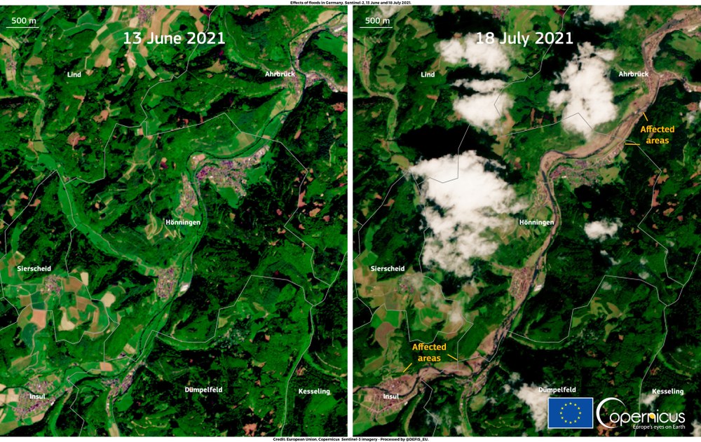
In the event of natural disasters, rescue teams and emergency services need an accurate and reliable overview of the situation as quickly as possible. As the affected regions are often completely cut off from their surroundings, Earth observation provides an important means of support in the form of high-resolution satellite images that can be used to generate a complete overview. Satellites can often capture detailed images within a matter of hours, regardless of cloud cover or daylight. Radar images in particular are very good at distinguishing between water and land areas, which is why they are very suitable for post flood disaster mapping. Satellite data also makes an important contribution to the investigation and monitoring of other catastrophic events such as earthquakes or forest fires.
Logo of the Charter
Logo of the International Charter 'Space and Major Disasters'
Credit:
International Charter Space and Major Disasters
The international charter ‘Space and Major Disasters’ is an international association of space agencies founded in 1999 by the European Space Agency (ESA) and the French space agency CNES.
The network provides national disaster management authorities and relief organisations with data from Earth observation satellites quickly and without red tape in the event of natural disasters or major technological hazards.
The International Charter Space and Major Disasters
Your consent to the storage of data ('cookies') is required for the playback of this video on Youtube.com. You can view and change your current data storage settings at any time under privacy.
The International Charter Space and Major Disasters
DLR's main contribution here consists of data from the German TerraSAR-X and TanDEM-X radar satellites. These satellites can acquire detailed images very quickly, regardless of cloud cover or daylight. As water and land areas can be easily distinguished from each other in the radar images, they are ideally suited for post-flood disaster mapping. TerraSAR-X data can also be helpful in the event of other natural disasters such as earthquakes. DLR has also been operating the German environmental satellite EnMAP since 2022. Thanks to its optical instrument, the hyperspectral satellite is able to make an important contribution to monitoring and situational awareness in the event of flooding or fire disasters when the skies are clear.
Universal access to the Charter
The German Space Agency at DLR is involved in the coordinating committees and supports the systematic further development of the Charter. In autumn 2012, the members launched what represents a milestone for the Charter: ‘Universal Access’. Previously, only authorised users from around 40 countries and United Nations organisations were able to request assistance from the Charter. ‘Universal Access’ now provides access to every national disaster management authority worldwide. The main purpose of this is to eliminate the large ‘white spots’ in Africa and parts of Asia and South and Central America and to give national authorities the opportunity to receive help from the Charter quickly and directly.
What happens in the event of a disaster?
Each activation of the charter begins with an incoming emergency call at ESRIN, the European Space Agency's site in Frascati (Italy). There the system verifies whether the person seeking help is an authorised user and whether all the necessary information has been provided. The Emergency On-Call Officer (ECO) is then deployed. This specialist first responder, who alternates weekly between the charter members, immediately requests the relevant satellite data from the participating space agencies. It is only a matter of hours from the receipt of the emergency call before the ECO completes his or her task.
The Executive Secretariat of the Charter then takes action. This is a group of employees from all Charter organisations spread across the globe. This Secretariat checks whether the emergency call in question is justified and whether activation of the Charter is appropriate. If the Secretariat decides that activation of the charter is not justified, the data orders placed by the ECO are cancelled. The Secretaries therefore have the task of ensuring that the resources provided by the Charter member agencies are used as intended and of monitoring the Charter's overall operation.
If the activation is justified, a Project Manager is appointed. At this point, information about the new activation is also published on the Charter website. The Project Manager is the link between the space agencies providing the data and those requesting assistance with their specific needs. The Project Manager ensures that the information is made available to users in the way they need it: For example, some civil protection authorities have the ability to analyse satellite images themselves, whilst others can only use ready-made maps. Since 2021, the ESA Charter Mapper has been providing a comprehensive platform that allows Charter users to efficiently examine large volumes of satellite data in the cloud and carry out important analyses. This means it is possible to react more quickly and conserve resources in the event of a disaster. The role of the Project Managers normally ends after approximately two weeks with the closure of the charter activation. The generated map products are then published on the Charter homepage.
DLR began providing organisational support for the charter via ESA in 2002, before becoming the eleventh full member in October 2010. Since then, the consortium has continued to grow. The German Space Agency at DLR works closely with the DLR Centre for Satellite Based Crisis Information (ZKI) in Oberpfaffenhofen as part of its Charter membership. The ZKI organises the provision of data, which is funded by the Federal Ministry for Economic Affairs and Climate Action (BMWK). It also assumes the ECO role for one week up to six times a year.