The Forest Ecosystems team uses modern remote sensing methods to analyze the condition, structure, diversity, and changes in forests. Our goal is to provide information products that support sustainable forest development in the context of global change.
Forests cover almost one-third of the global land area and fulfil key ecological, climatic, and social functions. They are habitats for countless animal and plant species, regulate water balance and microclimate, serve as recreational areas, and provide the renewable raw material wood. As potential carbon sinks, forests also play a key role in the global climate system. At the same time, they are under considerable pressure due to these diverse ecosystem services. In the Global South in particular, uncontrolled and often illegal deforestation, for example through raw material extraction and the expansion of settlement and agricultural areas, is leading to massive forest loss.
In Central Europe, forests are primarily affected by disturbances such as storms, insect infestations, and forest fires. The effects of climate change, such as prolonged periods of drought, are increasingly exacerbating these stresses. Near-natural, structurally rich forests are proving to be significantly more resilient. Forest conversion and reforestation to create site-adapted and species-rich stands are intended to develop stable and climate-resilient forest ecosystems in the long term. Tree species distribution, forest structure, and vitality are key parameters for estimating wood stocks and quantifying carbon sequestration. Preserving and restoring biodiversity while simultaneously exploiting forests for economic gain poses a particular challenge, as forest development processes take place over very long periods of time and require forward-looking management.
The Forest Ecosystems team uses Earth observation data to consistently record the condition, structure, vitality, species composition, and damage to forests over large areas. Long-term satellite time series enable continuous monitoring and analysis of changes caused by natural and anthropogenic processes. The aim is to develop application-oriented methods and information products that support decision-makers in implementing sustainable forest development. This includes mapping forest damage, structural changes, fragmentation, and vitality to quantify the effects of climate and land use.
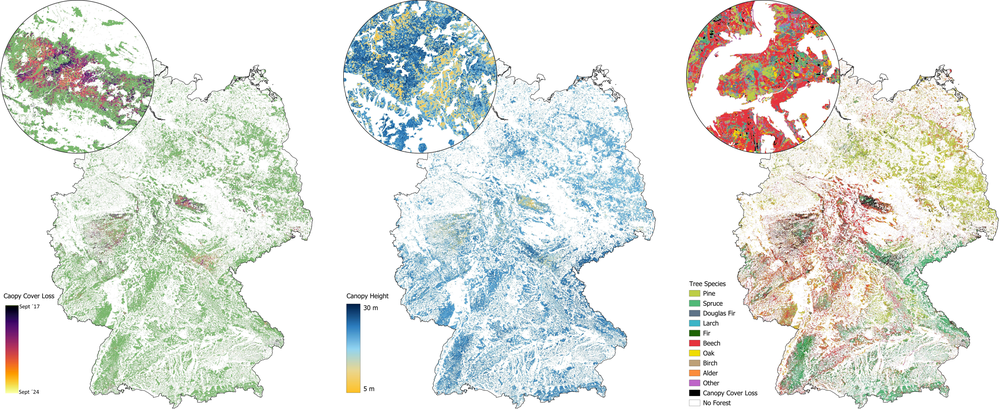
Geoinformation products for Germany
Forest canopy cover loss 2017 - 2024; Forest structure – canopy height 2023, Tree Species 2022
Forest condition and damage assessment: Near real-time and consistent monitoring of the effects of climate change, disturbances, forest use, and land use change on forest ecosystems.
Forest structure: Analysis of spatial structure, diversity, and fragmentation of forest stands.
Biodiversity research: Mapping tree species and investigating structure-biodiversity relationships.
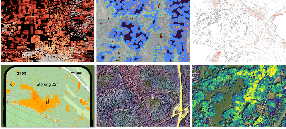
Examples of thematic analysis
Top row left to right: deforestation patterns in Paraguay; forest fragmentation in Bavaria; Germany's phenology. Lower row left to right: app for causes of disturbance; Hyperspectral image of Waldbrunn, Germany; Canopy height model for Bavaria
The work focuses on Central Europe and South America, but the methods can be applied worldwide. Data from the Copernicus Sentinel and Landsat missions are primarily used, supplemented by medium-resolution time series (MODIS, AVHRR) as well as radar, lidar, hyperspectral, and aerial image data. Modern methods of time series analysis, machine learning, and big data processing enable precise and automated analysis of large amounts of data.
Close collaboration with science, administration, and practitioners ensures that the results provide a solid basis for sustainable forest management and adaptation strategies. Our research supports knowledge-based decision-making in the environmental and forestry sectors. Intact and resilient forests make a key contribution to securing livelihoods by providing raw materials, regulating water balance and climate, and thus strengthening supply and adaptability to environmental and climate risks. The information bases we develop help to maintain these functions in the long term and promote ecological, economic, and social security.


