February 21, 2022 | Satellite data reveal extensive losses in the forest inventory
Concern about German forests
Total deforestation to curtail pests
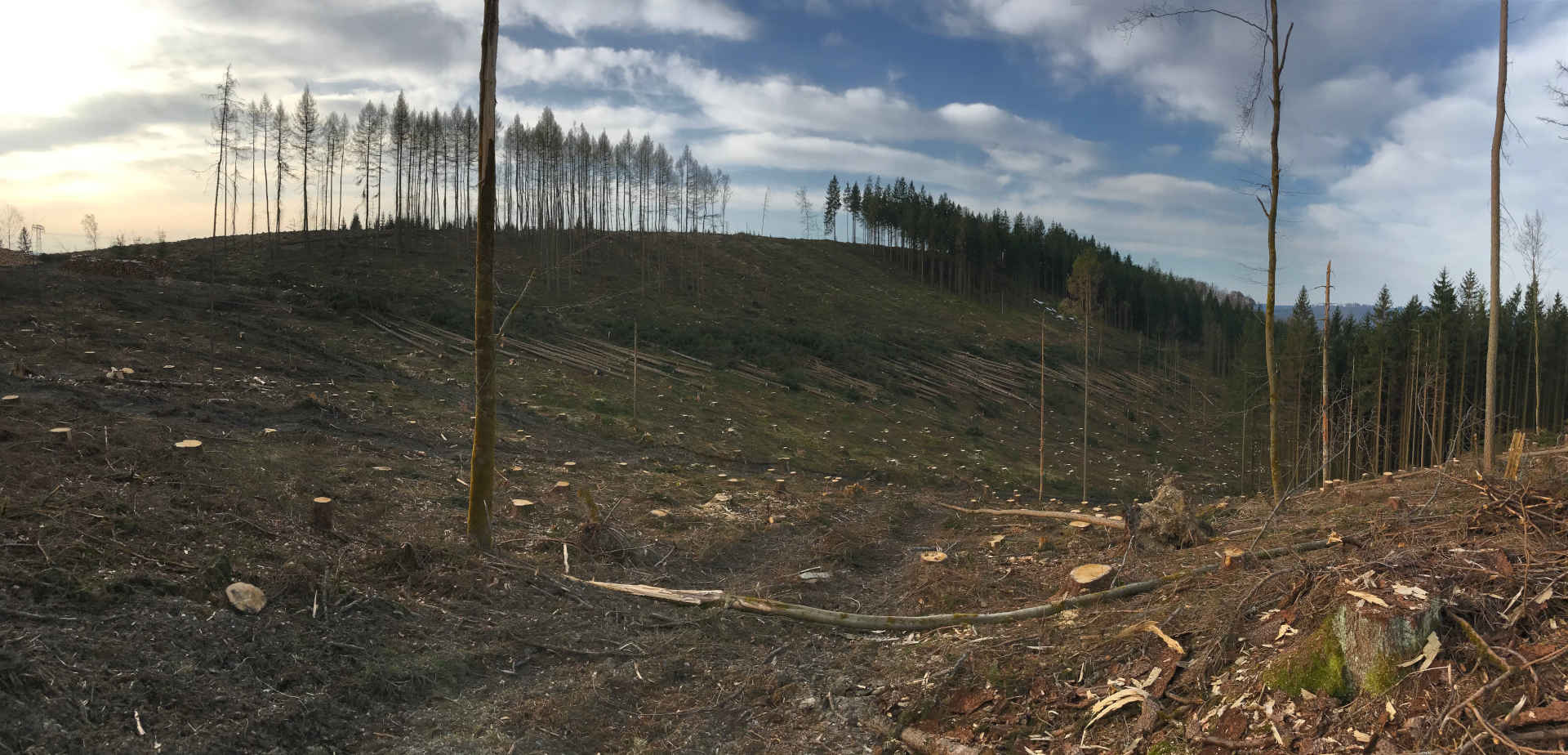
The forests affected by bark beetles are clearcut with heavy machinery. As a rule, nothing is left behind except twigs and branches. Such emergency loggings are often the last measure taken in the event of a massive pest infestation and particularly affect spruce trees. Through deforestation, the bark beetles are deprived of food, thus preventing their ability to spread. The picture shows an affected area in Steinach, district Sonneberg, Thuringia.
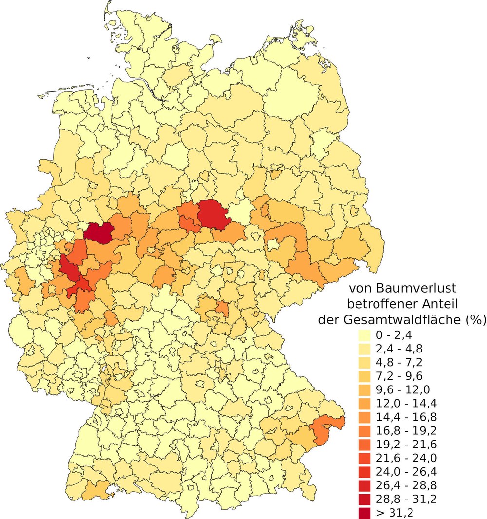
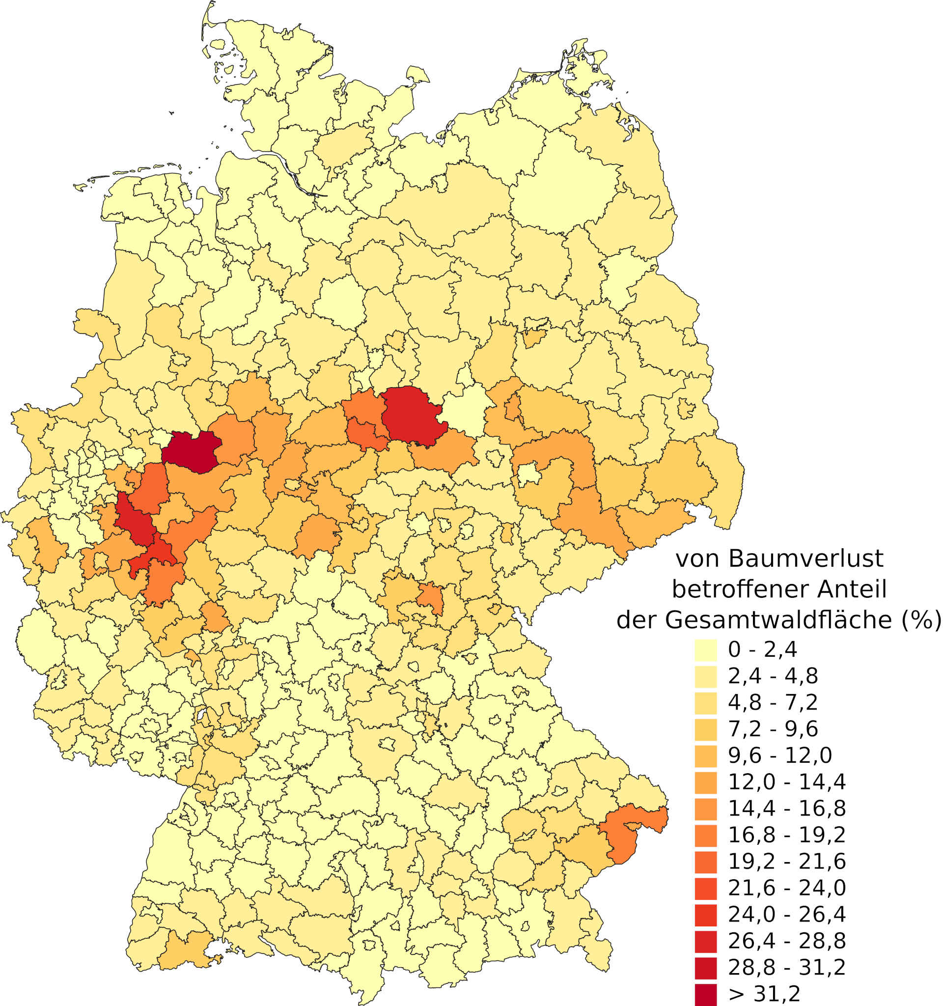
The illustration shows the amount of dead and, for the most part, already felled forest areas per district. Of note is that the highest percentage is exhibited in the middle of Germany from the Eifel, over the Sauerland and the Harz Mountains, and up to Sachsen. The coniferous forests there are especially affected. For this analysis, the DLR-Earth Observation Center (EOC) used satellite data from Sentinel-2 und Landsat-8 from the years 2018 to 2021.
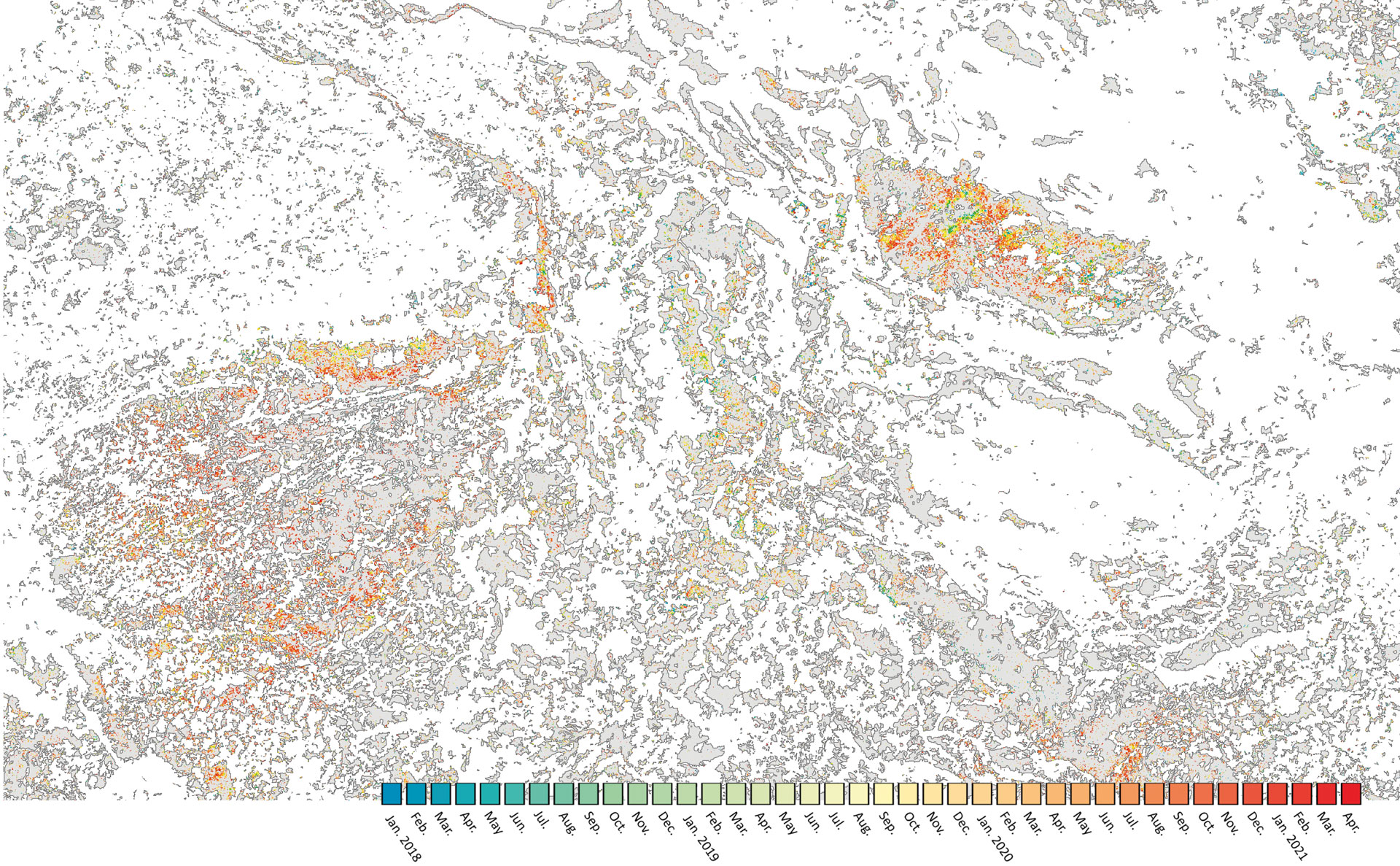
The map shows the forest loss in central Germany during the dry years from 2018 to 2020 at a spatial resolution of 10 metres. The colour scale marks the time period from January 2018 (in blue) to April 2021 (in red). Intact forest areas are represented in grey. Most notably is that the Harz Mountains (seen in the upper right area of the image) are especially affected by forest loss during the surveyed time period.
Forest loss in Germany is considerably higher than previously thought.
The Sentinel-2 and Landsat-8 satellite reveal the extent of the damage for the first time: the conifer forests in the middle of Germany are affected the most.
Earth observation satellites can capture tree loss nation wide and on a monthly basis.
Focus: Space, Earth Observation, Global Change
Healthy trees have a dense crown. However, a walk through the forest reveals that the green canopy is generally quite sparse. In recent years more and more deforested areas have become evident. Forests are our green lungs, create habitats for a diverse world of flora and fauna, provide timber, and protect against floods and slope collapse. How large is the loss caused by forest die-off and tree removal? Researchers at the German Aerospace Center (DLR) are addressing this question with the help of satellite earth observation data. For the first time, they have made visible how much of the forest inventory has been lost throughout Germany. The results are alarming: from January 2018 to and including April 2021, some 501,000 hectares of tree loss have been noted in Germany. This is an amount almost equivalent to five percent of the entire forested area, and thus considerably more than previously assumed. The triggers are primarily considered to be unusually intensive periods of heat and drought in these years, which in turn favoured infestation by harmful insects.
Support from space
Access to comprehensive forest information is important for forest management staff in order to map tree species, differentiate the causes of damage, and prevent negative developments by early detection. Earth observation satellites can supply the requisite spatial and temporal resolution. The potential inherent in satellite images is however not yet being fully utilized by public authorities. The DLR research team at the Earth Observation Center (EOC) has contributed its expertise. In order to precisely estimate tree loss, it used as data sources the Copernicus Sentinel-2 satellite of the European earth observation programme and the US Landsat-8 satellite.
The satellite data presently available can be analysed to precisely determine large-scale loss in the forest canopy. The images also make drastic damage readily visible, such as the complete die-off of groves. Another advantage is the frequency of updating. Satellites can provide data of high temporal density.
Monoculture, weather extremes and insects
The view from space shows that it is mainly central Germany with its conifer forests that is affected, from the Eifel and Harz mountain ranges to the Thuringian Forest and the heights of Saxon Switzerland. In three years, the state of North Rhine-Westphalia alone lost more than a quarter of its pine forests and, in some counties, over two-thirds. Trees died or were sacrificed in large-scale distress felling. Deforestation is often the last measure in cases of massive pest infestation. It is undertaken in the case of pine trees in order to remove the bark beetle food supply, thereby preventing their further spread.
While deciduous trees like oak can recover from insect infestation, this is frequently not the case for conifers. After the second world war, Germany was reforested with pine trees as a top priority, sometimes in unsuitable locations, because they were the most important lumber source. These forests thus have similar age and growth structures and as monocultures are less resilient. Between 2018 and 2020 all of central Europe was ravaged by several unusually long periods of drought and heat waves. This weakened the green giants—the deficits in ground moisture are still measurable today. At the same time the dry heat provided ideal conditions for bark beetles, so their populations increased explosively.
Not only pine forests are affected by the consequences of drought. "Our analyses show that oak, beech and spruce – in addition to pine the most common tree species in Germany, show considerable damage. The same is true for less common species like sycamore and larch," explains Dr. Frank Thonfeld of the DLR Earth Observation Center (EOC). "The annual forest survey reports drawn up by public authorities now make it evident that the condition of German forests has continuously deteriorated already for a long time. But the damage caused in the last few years is unprecedented."
In addition to pest infestation, German forests also suffered blowdown loss. The DLR research team identified these wind-damaged areas with the help of highly precise satellite images derived from Sentinel-2 and Landsat-8 data. The assessments revealed, for example, the extent of storm damage in eastern Bavaria, Saxony-Anhalt and Saxony. The present Germany-wide storm situation will probably again require the removal of wind-damaged wood in many locations.
Big data on forest development
The remote sensing experts in Oberpfaffenhofen evaluated over 20,000 datasets. In this way they were able to identify forest die-off and newly felled areas on a monthly basis. The result is a differentiated forest survey for all of Germany at a resolution of ten meters. The processing of the Sentinel-2 and Landsat-8 data archives was completely automated. This highly complex procedure was developed at EOC and is being optimized for other applications.
The methodology for interpreting the forest inventory can also be applied in other countries and regions. Large-scale forest damage is not only a German, but also an European concern. Neighbouring countries like the Czech Republic and Austria are facing similar challenges. In the mid-term it can also be expected that more forest stands will be lost. It will take decades before the economic repercussions are surmounted, and it can take even longer for the forest ecosystem to recover. It is therefore urgent that Germany and Europe promptly initiate efficient measures to protect forests. Satellite-supported earth observation can provide researchers and decision makers with the needed data basis.
Just as the new methodology can be customized for particular users, the new maps can be also be brought up to date at any time. In the future, the DLR research team could provide satellite data on forested areas to forest authorities on a monthly basis and thus provide long-term support of ongoing forest management in all regions.
Forest survey report
German forests have been monitored in Germany since 1984 when fears of forest death were rampant. The annual forest survey report provided by the Federal Ministry of Food and Agriculture, the "Waldzustandsbericht", documents the state of the canopy for the main tree species spruce, pine, beech and oak. This is done by spot-checking designated monitoring areas. These are therefore snapshots of a manageable number of observation or data points. The reports designate only the areas that need to be reforested after loss. Quantitative information about the areas actually affected by tree loss are not normally included. Earth observation satellites can supply supplementary data in these cases.


