The "Agroecosystems and Food Security" Team analyses the world's agrarian regions with satellite earth observation time series. and develops for decision makers and scientists information products and services that relate to their sustainable development.
Data Products for Germany
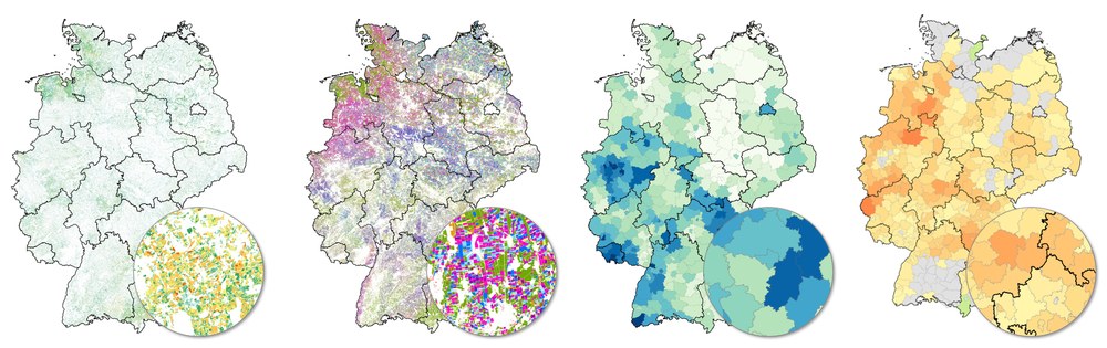
Examples of the team's Germany-wide products for analysing agrarian ecosystems. From left to right: grassland mowing frequency, crop types, crop diversity, vegetation stress.
Our research concerns areas under cultivation around the world in which food and resources are being produced for a growing population. In this connection remote sensing data and information products as well as tools for sustainable development in agrarian ecosystems are being created.
Main topics:
Agrarian ecosystems – We analyse agrarian settings and how they have changed over the past decades. Aspects like management practices, utilization intensity, ecologically relevant landscape elements, as well as entire agrarian landscape structures are quantified and studied in detail. The focus is on the influence of climate change and options for adaptation and on the importance of agrarian landscapes for material cycles, food security and biodiversity.
Sustainable Development – We develop the data groundwork for supporting sustainable adaptation and reduction strategies in the context of global change. Our information products are relevant for planning and research efforts, for public policy makers and authorities, and for the private sector. They provide knowledge-based decision support toward the goal of maintaining and improving food security, ecosystem functions and services, and biodiversity in a changing world.
Regional and international products
Examples of the team's satellite-based products for analysing agrarian ecosystems in various earth regions. From left to right: global net primary production; tree cover extent of dry vegetation, photosynthetically active vegetation, and open ground in West Africa; ca. 40-year vegetation-index time series for Europe; hedgerows in southern Germany; agricultural land and wind barriers in South America; rice cultivation in West Africa.
The "Agroecosystems" Team investigates methods for automating Information extraction from earth observation data in order to monitor long-term and current developments and processes in agrarian ecosystems in the context of global change, to analyse them, and to provide appropriate information products for decision makers and researchers. The team develops methodologies, processing chains and geoinformation products based on earth observation data from different sensors with varying spatial, spectral and temporal characteristics. The emphasis is on evaluating data from the Copernicus-Sentinel and Landsat missions. But also mid-resolution time series (MODIS, AVHRR) and hyperspectral and aerial data form an important foundation. The methodological emphasis is on procedures for time series analysis and AI applications and on the processing of large, heterogeneous quantities of data (Big Data). Satellite data are typically complemented by data sets, statistics and terrain measurements from non-remote-sensing disciplines. Our focus is on the great challenges facing society, with the goal of supporting sustainable development for food security and resilient ecosystems.


