The focus of the Multimodal Navigation group is to explore solutions for multimodal navigation of passengers in urban environments. The focus relies on public transport and sustainable individual transport modes used for the first/last mile, such as bicycles, e-scooters and walking.
This group has long-standing expertise in sensor-fusion techniques for pedestrian navigation in key urban environments where satellite navigation is unavailable or hindered, such as train stations and airports.
This group has extensive experience as well with machine learning techniques for passenger activity recognition and identification of transport modes. The methods developed for seamless identification of the means of transport have been patented.
The research of the Multimodal Navigation group enables integrated mobility services such as Location-Based Services or E-Ticketing. Therefore, the research carried out in this group supports applications in the public transport and makes an important contribution to a sustainable digitization of the transport system.
Passenger Mobility
Development of artificial intelligence algorithms to recognize the modes of transport chosen by users of the public transport network - for better management and planning of the networks
With the growth of cities, the management of public transport networks becomes more difficult. That has a huge impact in the comfortability of passengers using the public transport network.
We envision a seamless and easy access to the public transport in cities for everyone. One way to foster this concept is developing smartphone-based systems for the automatic billing for the use of public transport.
We concentrate in developing artificial intelligence algorithms to recognize the mean of transport that the users of the public transport network are using. Concretely, we concentrate in detecting the use of buses, trams, subways and short-distance trains. This will allow a better management of the public transport network, and a better planning of the city.
Active traffic modes
Research for urban mobility - people navigation with wearable sensors, smartphone-based people localization, data-driven movement models for bicycles that enable more realistic simulations of passenger flows, collision avoidance
For more than 20 years, we have developed algorithms for personal navigation using wearable sensors, particularly inertial sensors, barometer and magnetometer. We have concentrated on professional use-cases, such as firefighters or rescue teams. Since 2017, we opened our research area to the urban mobility. Firstly, we developed a navigation system for bicycles and we integrated the two active transport modes together, i.e. walking and riding a bicycle. Our next step was to add to our multi-sensor approach the satellite navigation. In 2019, we transformed our algorithms to work with the low-cost sensors embedded in commercial smartphones.
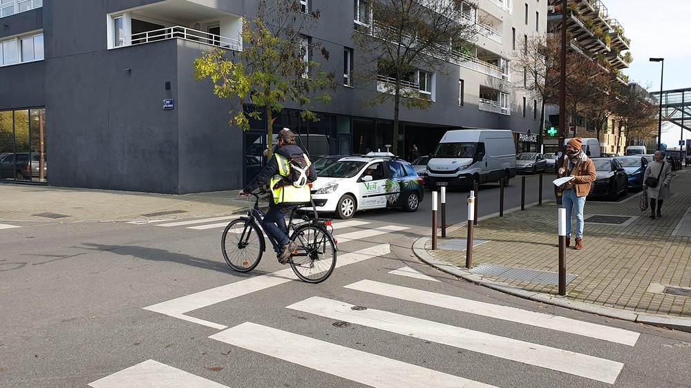
Currently, we focus our research in developing an enhanced smartphone-based passenger localization in stations, airports and on the bicycle. In addition, we develop data-driven movement models for bicycles that enable more realistic simulations of passengers’ flows, e.g. in SUMO. Furthermore, we work on increasing the awareness of other traffic participants towards the cyclists with the aim of avoiding possible collisions.
Digital twins of traffic flows
Digital twins help anticipate, think ahead, and plan ahead, leading to a better planned, safer, and more trustworthy transportation network.
In the last years, the digitalization of cities is becoming a reality. In the frame of the urban mobility, we pursue creating a digital twin of the public transport network. Digital twins help anticipate, think ahead, and plan ahead, leading to a better planned, safer, and more trustworthy transportation network.
We currently focus our effort in extracting the real-time passenger flows in the transport network. The use of this traffic flows leads to avoiding bottlenecks and the creation of what-if scenarios, which improve safety of passengers.
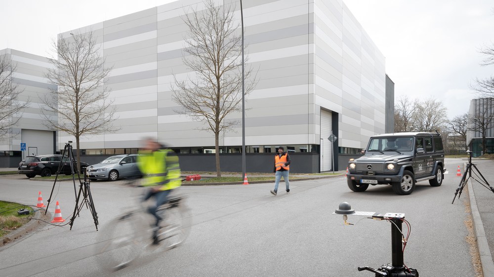
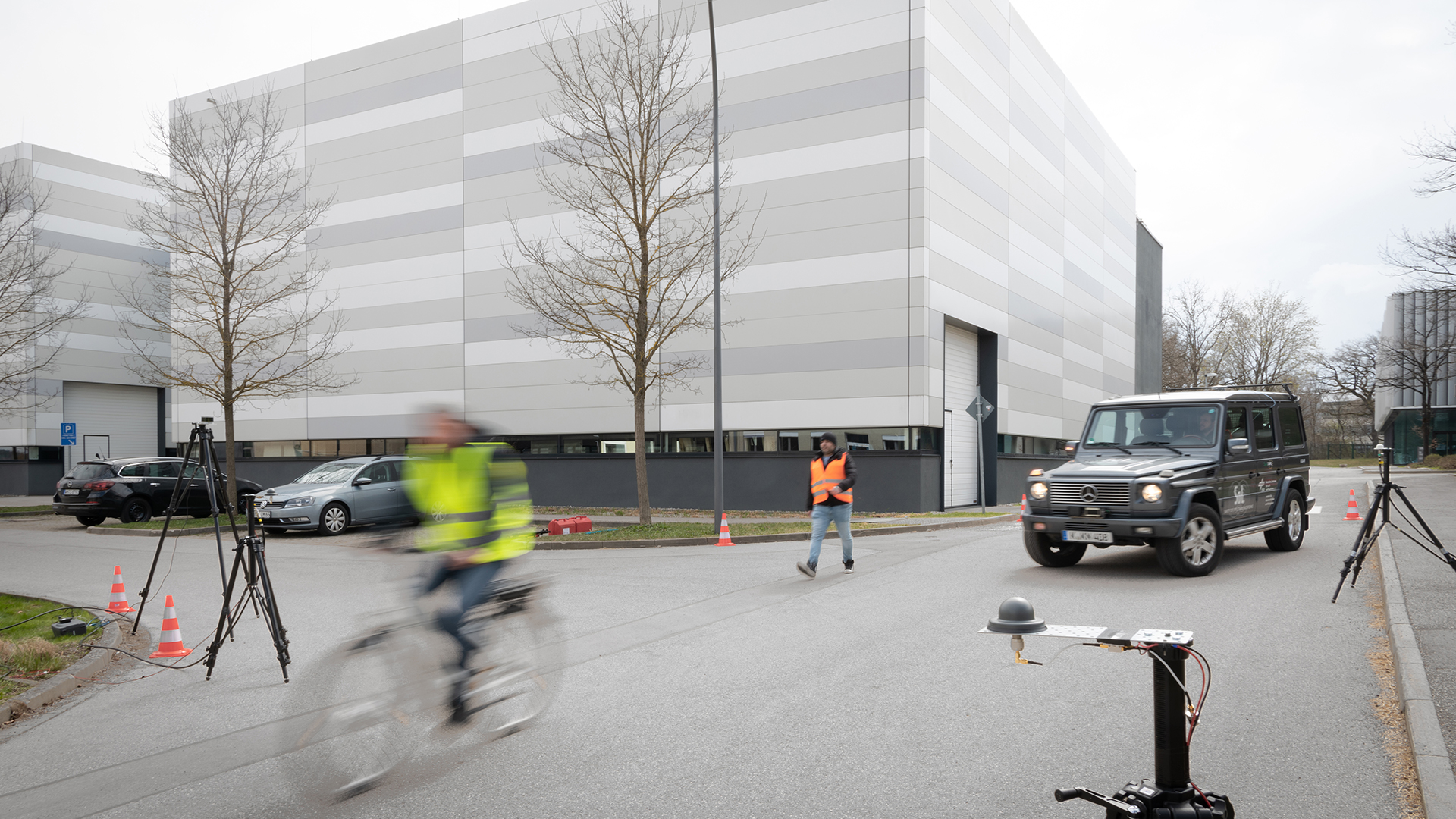
Die im Smartphone integrierten Sensoren messen die Position und Geschwindigkeit des Radfahrers. Diese Daten sowie die Fahrzeugposition und -geschwindigkeit werden an die App übermittelt, die dann eine mögliche Kollision voraussieht und eine Warnung auslöst.
Radfahrer in Gefahr wegen eines möglichen Zusammenstosses mit einem motorisierten Fahrzeug
Your consent to the storage of data ('cookies') is required for the playback of this video on Quickchannel.com. You can view and change your current data storage settings at any time under privacy.
Radfahrer in Gefahr wegen eines möglichen Zusammenstosses mit einem motorisierten Fahrzeug
Die im Smartphone integrierten Sensoren messen die Position und Geschwindigkeit des Radfahrers. Diese Daten sowie die Fahrzeugposition und -geschwindigkeit werden an die App übermittelt, die dann eine mögliche Kollision voraussieht und eine Warnung auslöst.

