Human activity has led to a large increase in the abundance of greenhouse gases (GHGs) compared to pre-industrial values, which in turn has led to anthropogenic climate change. Carbon dioxide (CO2) and methane (CH4) are the most important of these human-influenced trace gases from a climate perspective, and tracking their budgets is critical. Measurements of their atmospheric abundance can be used to estimate the magnitude and distribution of their sources and sinks at the earth’s surface using “top-down” methods, also known as atmospheric inverse modelling. An improved knowledge of these surface fluxes helps us better understand the natural carbon cycle and its response to climate change, but can also provide independent information about anthropogenic emissions to the atmosphere. This tracking of emissions is key to monitoring progress on emissions reduction targets, such as in the context of the Paris Agreement.
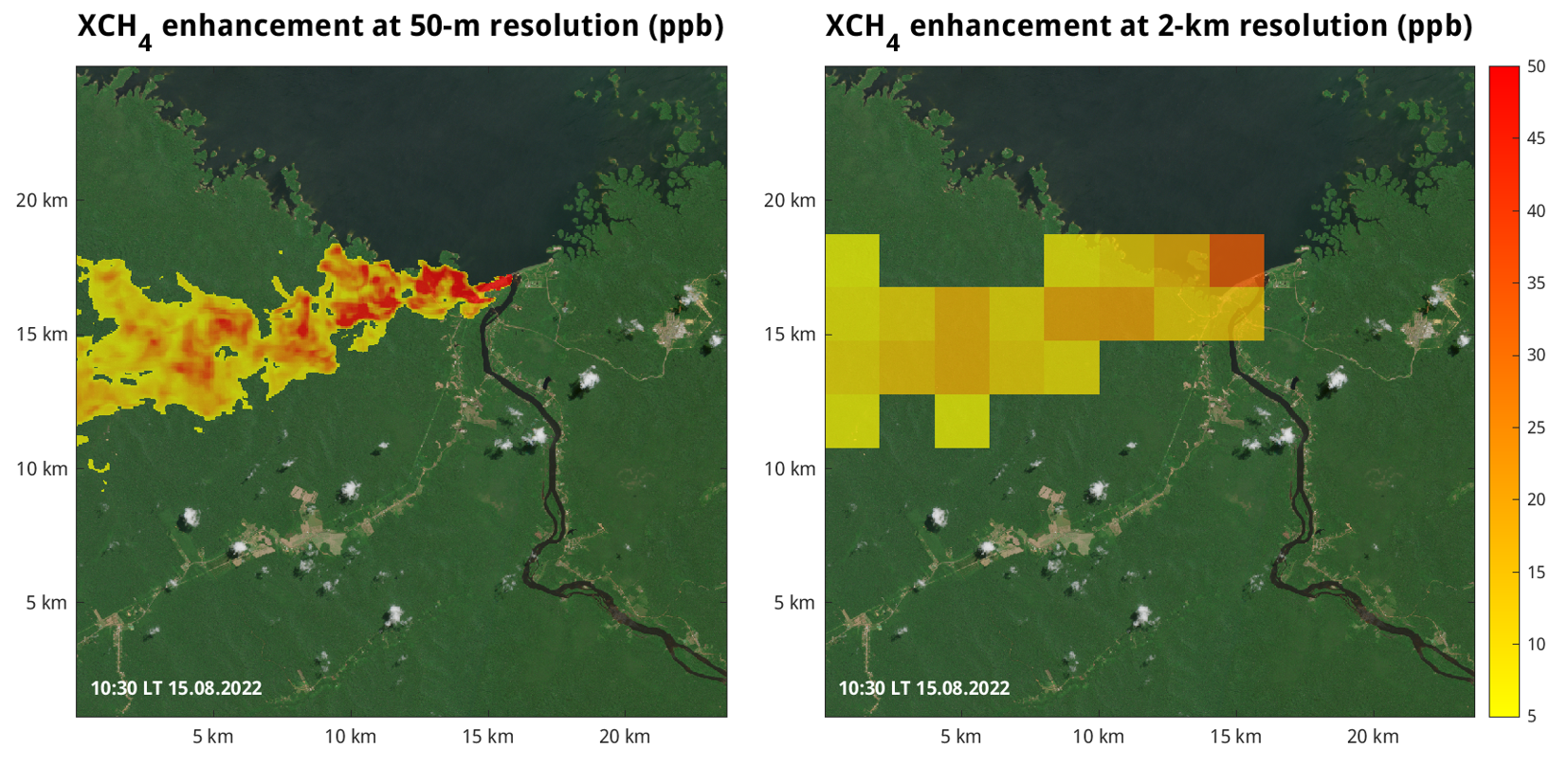
Simulation of total-column methane enhancement (XCH4, in parts per billion) for methane emissions from the turbines of the Balbina dam, estimated to be 34 GgC/year. The panel on the left shows how the enhancement would be seen at 50-m spatial resolution (as for CO2Image), and the panel on the right whos the enhancement at 2-km spatial resolution (as for CO2M). Copernicus Sentinel data 2022 were used for the background image.
Satellite measurements of atmospheric greenhouse gases provide a wealth of information about the distribution of both methane and carbon dioxide, allowing for processes on a variety of spatial scales to be studied. To this end, we are performing inversions on both global and regional scales, using existing measurements from existing satellites, aircraft-based sensors, and ground-based observations. Furthermore, we are working with teams developing innovative new missions.
Current research questions include:
In the context of a planned high-resolution CO2 imager mission being developed at DLR (CO2Image), how can we best estimate emission strength from images of plumes from point sources, and how can we optimize the sampling?
How well can we constrain national emissions estimates of CO2 using satellite and ground-based measurements, and how will this change with the launch of the CO2M constellation?
Making use of existing satellite measurements of methane, can we attribute the atmospheric growth rate to specific processes (e.g. wetlands, agriculture, oil and gas)?
What additional information about methane fluxes will be provided by MERLIN, an active lidar satellite mission being developed by DLR and CNES?
How can we use additional remote sensing measurements to constrain estimates of biospheric fluxes?
For this research we make use of atmospheric transport models on a range of spatial scales. We work closely with teams developing satellite instruments and missions, as well as scientists working on the retrieval of column-integrated trace gas abundances from satellite measurements. Through these efforts we are involved in various national and international projects, developing innovative techniques to interpret these rapidly-expanding spaceborne measurements.
Contact
Dr Julia Marshall
Institute of Atmospheric Physics
Atmospheric Trace Species
Münchner Straße 20, 82234 Oberpfaffenhofen-Wessling


