New Study on the Predictability of the Middle Atmosphere
September 23, 2025
New Study on the Predictability of the Middle Atmosphere
While weather near the Earth’s surface can in principle be predicted up to about two weeks in advance, the predictability window is only about half as long in higher layers of the atmosphere. The reason lies in small-scale waves that rapidly transport disturbances upward. Still, there is hope: large-scale circulation patterns remain predictable in higher layers for up to three weeks – offering the potential benefit of predicting atmospheric disturbances that can lead to disruptions in signals of satellite-based navigation and communication systems.
Predictability of flow in the mesosphere/lower thermosphere
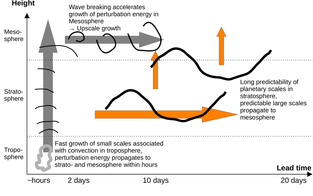
Schematic showing key processes that affect the predictability of flow in the mesosphere/lower thermosphere (MLT) over lead time since starting the forecast. Gray arrows denote propagation of perturbations ("errors") via small-scale motions and orange arrows highlight more predictable large-scale flow components, leading to predictable circulations in the MLT for lead times up to 10–20 days.
The atmosphere is a complex and chaotic system, and therefore, atmospheric circulation cannot be predicted indefinitely in advance. For weather in the lower atmosphere (the troposphere) this is well studied: the limit of weather predictability is about 10 days to two weeks. Far less is known, however, about the predictability of higher atmospheric layers.
These layers are becoming increasingly important. In recent years, it has become clear that upper atmospheric motion can influence the ionosphere – a region containing electrically charged particles. Ionospheric disturbances can cause signal problems for modern satellite-based navigation and communication technologies. This makes it all the more crucial to forecast such disturbances in advance. It is expected that predictions of the atmospheric state and waves propagating upward from the lower atmosphere could improve forecasts of ionospheric disturbances. Until now, however, little was known about how long the atmosphere remains predictable in the relevant height region – the Mesosphere to Lower Thermosphere (MLT), located about 50–120 kilometers above Earth.
A new study conducted at the Institute for Physics of the Atmosphere now shows that the atmosphere in these layers remains predictable for a much shorter time than near the surface. Small uncertainties in the initial conditions grow particularly fast there. As a result, forecasts are only possible for about 5–6 days – roughly half as long as in the troposphere. The main reason lies in small-scale atmospheric waves, which propagate upward from the Earth’s surface into higher layers, thereby increasing strongly in amplitude. They can transport disturbances upward within just a few hours. For forecast models, this means: only if these waves are properly represented can realistic assessments of predictability be made.
Nevertheless, despite the short predictability of small-scale disturbances, there is hope for “weather forecasting” in higher atmospheric layers. On larger scales – circulation systems spanning several thousand kilometers – the atmosphere remains predictable at altitudes of 60–100 km for up to three weeks. This opens the door to predicting the influence of atmospheric waves on ionospheric disturbances potentially weeks in advance.
Garny, H. (2025). Intrinsic predictability from the troposphere to the mesosphere/lower thermosphere (MLT). Journal of Geophysical Research: Atmospheres, 130, e2025JD043363. https://doi.org/10.1029/2025JD043363

