Aeolus and Aeolus-2

The Aeolus mission
The knowledge of wind speed is crucial for both weather forecasting and the understanding of atmospheric dynamics. Therefore, experts of the World Meteorological Organization (WMO) have repeatedly stated that the global measurement of wind profiles is of highest priority. In August 2018, after a development period of 16 years, the European Space Agency (ESA) had launched the Earth Explorer Satellite Aeolus into space. Named after the Greek god of the winds, the satellite carried the revolutionary instrument ALADIN - the first European lidar and the world's first Doppler wind lidar in space. The Aeolus mission was a great accomplishment for the European space sector and ended in July 2023 with the world's first assisted re-entry of the satellite into the Earth's atmosphere.
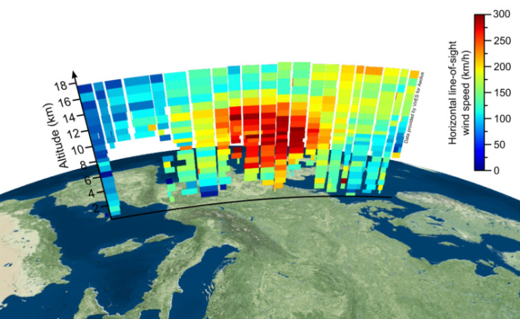
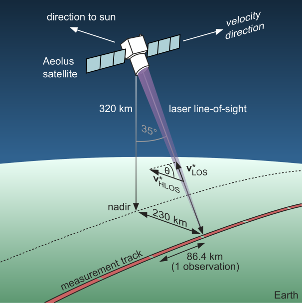
ALADIN essentially consisted of a pulsed, ultraviolet laser, a reflecting telescope with a diameter of 1.50 metres and a highly sensitive optical spectrometer. The emitted laser pulses were scattered in the atmosphere by air molecules, aerosols and cloud particles that moved with the wind, so that a small portion returned to the satellite. The wind speed was derived from the frequency difference between emitted and backscattered pulses which was caused by the Doppler effect, while the duration of the pulses contained the altitude information. In this manner, global wind profiles were measured from the ground up to altitudes of 30 kilometers with a resolution of 0.5 to 2 kilometres and a random error between 3 to 7 metres per second. Initially considered a technology demonstrator, the wind data from Aeolus were directly incorporated into weather forecasting models, where they closed large data gaps in the global observation system, especially over the oceans and in the tropics.
The Aeolus Data Innovation and Science Cluster (DISC)
The algorithms and processors required to derive wind profiles from the raw measurement data of ALADIN were developed by an international team including the DLR institutes IPA and IMF, the companies DoRIT, ABB, S&T and Serco, and several European weather services (ECMWF, Météo-France, KNMI). Within the Aeolus Data Innovation and Science Cluster (DISC), this international consortium under the lead of DLR-IPA was responsible for monitoring and improving the data quality. Besides the further development of processors, studies on the influence of Aeolus data on weather forecasting belong to the responsibilities of Aeolus DISC. Already one year after launch of the satellite, Aeolus DISC scientists have brought the data quality to such a high level that the European Centre for Medium-Range Weather Forecasting (ECMWF) had been able to demonstrate a positive impact of Aeolus data on the weather forecasts. Between 2020 and the end of the mission in 2023, the Aeolus data was used for the daily weather forecasting at ECMWF and other major weather services around the world such as the German Weather Service (DWD) and Météo-France. The DISC continues its work during phase F of the Aeolus mission with a focus on the reprocessing and improvement of the quality of the Aeolus data collected over the five-year mission lifetime.
The follow-on mission Aeolus-2
Despite the great importance of wind for weather and climate, the height-resolved, global acquisition of wind profiles only became possible with the development of ALADIN which was an enormous technological challenge. Thanks to successful Aeolus mission European research and industry have taken a global leadership role in lidar technology. Consequently, the ESA Ministerial Council Conference in November 2022 paved the way for an operational Aeolus follow-on mission as a cooperation between ESA and EUMETSAT with launch in the mid-2030s.
Validation Campaigns
The technical and scientific functionality of the satellite instrument was already demonstrated in advance of the Aeolus mission with a prototype instrument, the ALADIN Airborne Demonstrator (A2D). This direct-detection Doppler wind lidar, developed by DLR and Airbus, was deployed in several campaigns aboard the research aircraft Falcon to accurately measure, for example, the North Atlantic jet stream. This allowed to validate the measurement principle, to optimize the operation procedures and to improve the wind retrieval algorithms already before the start of the satellite.
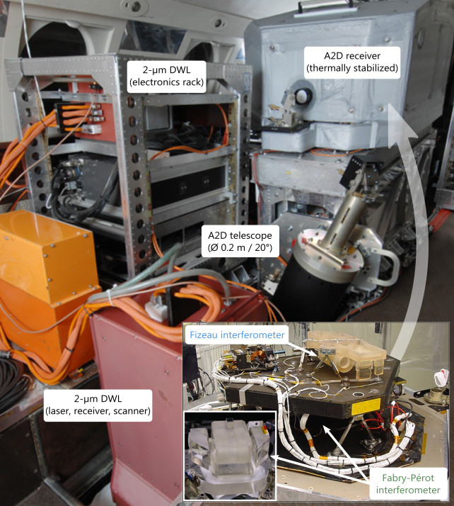
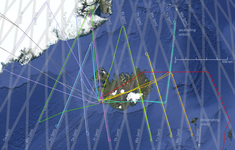
During the nearly five-year mission, four airborne campaigns were conducted to validate the satellite instrument. Besides the A2D, also the 2-µm Doppler wind lidar was used aboard the DLR Falcon. While the first two campaigns were conducted from Oberpfaffenhofen in November 2018 and May 2019, the base for the third validation campaign was located in Keflavík, Iceland. The fourth airborne, AVATAR-T, was carried out as part of an international cooperation project organized by ESA and NASA in September 2021 on Sal, Cabo Verde. A total of 31 satellite underflights were performed during the four campaigns, with wind measurements being taken over a distance of more than 26,000 kilometres along the satellite measurement track. Using this extensive data set under various conditions with respect to season, geographical region as well as ground albedo, cloud types and atmospheric dynamics, the quality of the Aeolus data products was assessed in detail and processor updates were proposed. The validation campaigns thus made a significant contribution to the refinement of the data processors and to improving the quality of the satellite data.