Between 2018 and 2023, the European Space Agency (ESA) satellite Aeolus was operated in space. Named after the Greek god of the Winds, the satellite carried the instrument ALADIN (Atmospheric LAser Doppler lidar INstrument) as its single payload. It was the first European lidar and the world's first ever Doppler wind lidar in space. Consisting of a pulsed ultraviolet laser, a telescope (1.50 m diameter) and a highly sensitive optical spectrometer, ALADIN measured one component of the wind vector along the laser line-of-sight from ground up to altitudes of 30 kilometers with a resolution of 0.5 km to 2 km and an accuracy of about 2 m/s to 5 m/s. The emitted laser pulses were scattered in the atmosphere from air molecules, aerosols and cloud particles that moved with the wind, so that a small portion returned to the satellite. The wind speed could be derived from the frequency difference between emitted and backscattered pulses which is caused by the Doppler effect, while the duration of the pulses contained the altitude information. The obtained wind data were directly incorporated into weather forecasting models, where they closed large data gaps in the global observation system, especially over the oceans and in the tropics, thereby improving the accuracy of the forecast.
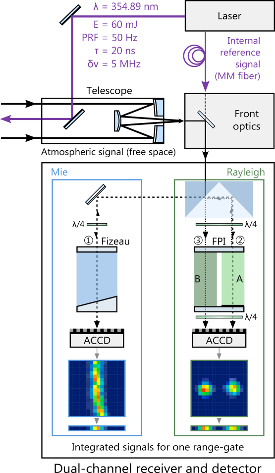
Already several years before the satellite launch, an airborne prototype of the direct-detection Doppler wind lidar, the ALADIN Airborne Demonstrator (A2D), was developed at DLR in collaboration with the space industry EADS-Astrium (now: Airbus Defence and Space). The A2D provides high data coverage under various atmospheric conditions with regard to cloudiness and aerosol content thanks to the special design of the receiver, which - like the satellite instrument - has two complementary channels. While the Doppler frequency shift from the molecular backscatter signals is determined in the Rayleigh channel consisting of two Fabry-Pérot interferometers, the analysis of the particulate backscatter from clouds and aerosols is performed with the Mie channel based on a Fizeau interferometer. Due to its representative design, the A2D served to demonstrate the technical and scientific functionality of the satellite instrument prior to the mission. For this purpose, the A2D was deployed in several field campaigns aboard the DLR research aircraft Falcon to accurately measure, for example, the North Atlantic jet stream. This allowed to validate the measurement principle, to optimize the operation procedures and to improve the wind retrieval algorithms already before the start of the satellite.
During the nearly five-year Aeolus mission, four airborne campaigns were conducted to validate the satellite instrument. Besides the A2D, also the 2-µm Doppler wind lidar was used aboard the DLR Falcon. In the frame of the four campaigns (WindVal III in Oberpfaffenhofen in November/December 2018, AVATAR-E in Oberpfaffenhofen in May/June 2019, AVATAR-E in Iceland in September 2019 and AVATAR-T on the Cape Verde Islands in September 2021, a total of 31 satellite underflights were carried out during the three campaigns, with wind measurements being taken over a distance of more than 26,000 kilometres along the satellite measurement track. Using this extensive data set under various conditions with respect to season, geographical region as well as ground albedo, cloud types and atmospheric dynamics, the quality of the Aeolus data products was assessed in detail and processor updates were proposed. The validation campaigns thus made a significant contribution to the refinement of the data processors and to improving the quality of the satellite data.
Key instrument parameters of ALADIN on Aeolus and the ALADIN Airborne Demonstrator
Parameter
ALADIN
ALADIN Airborne Demonstrator (A2D)
Laser wavelength
354.8 nm
354.89 nm
Repetition rate
50.5 Hz
50 Hz
Pulse energy
60 mJ (Feb. 2020)
60 mJ
Line width
30 MHz (FWHM)
50 MHz (FWHM)
Telescope diameter
1.5 m
0.2 m
Line-of-sight slant angle
35°
20°
Lidar principle
Direct-detection with double-edge and fringe imaging technique
Direct-detection with double-edge and fringe imaging technique
Receiver
Sequential Fabry-Pérot interferometers for molecular backscatter (Rayleigh channel) and Fizeau interferometer for particulate backscatter (Mie channel)
Sequential Fabry-Pérot interferometers for molecular backscatter (Rayleigh channel) and Fizeau interferometer for particulate backscatter (Mie channel)