
ELK: Mapping the national, regional & global emissions of transport
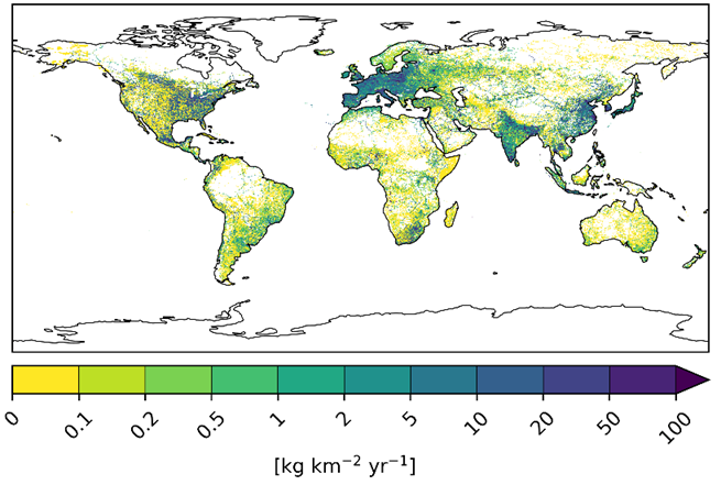
- Global inventories of CO2 and non-CO2 emissions from transport (land-based transport, shipping and aviation) were generated, also accounting for indirect transport-related emissions from the energy sector and with a unique distinction between emissions of different subsectors (e.g. cars vs. trucks, passenger vs. freight).
- Noise maps were created for road and rail transport in Germany, for the most important German airports and for the about 23,000 on-shore wind turbines in Germany. Noise from road transport and aviation was also modelled for the region of Hamburg.
- As particular use-case within the region of Hamburg, highly-resolved transport emission data was combined using detailed atmospheric models to produce air quality maps for an urban environment.
The emissions from both transport and related sectors significantly contribute to climate change. Transport emissions are continuously growing, challenging the achievement of the climate goals set by the Paris Agreement. The transport sectors are not only particularly harmful to air quality, but are also a major source of noise pollution. Currently available inventories do not consistently cover neither the emissions (gas, particles and noise) of all transport sectors (land-based transport, shipping and aviation) nor the transport-related emissions from the energy sector or emissions resulting from vehicle production and the operation of the transport infrastructure. Moreover, available inventories do not allow emissions to be differentiated across different subsectors (e.g., cars only). Yet such data is essential for accurately quantifying the impact of transport at global, European and national levels, also in consideration of the foreseen transition of mobility towards other energy sources. Emission inventories are also necessary to develop future emission scenarios as well as to assess climate protection policies or measures for both the improvement of air quality and the reduction of noise pollution.
To address these topics, DLR’s interdisciplinary expertise was used to set up the strategic impulse project EmissionsLandKarte (ELK; en.: Emission Map), in which 24 institutes successfully worked together under the leadership of the Institute of Atmospheric Physics (Oberpfaffenhofen) and the Institute of Transport Research (Berlin). The results of the ELK project are intended to serve as primary source of information for different stakeholders and target groups, for instance national stakeholders and authorities, the scientific community of climate, air quality and noise modelling as well as the Intergovernmental Panel for Climate Change (IPCC).
Global emission inventories

Global emission inventories were generated for land-based transport, shipping and aviation. The indirect transport emissions from the energy sector (oil refineries) and transport-related emissions from the industry sector were also quantified. The inventories include emissions from greenhouse gases (CO2, CH4 and N2O) and from short-lived climate forcers like nitrogen oxides (NOx = NO + NO2), sulphur dioxide (SO2) und particles (black and organic carbon). For land-based transport, non-exhaust emissions of particulate matter due to tire and brake wear were considered as well. The emissions were mapped on a 0.1° x 0.1° grid. Aviation emissions were calculated on a three-dimensional grid, also considering the vertical distribution at flight levels. The data is available as monthly and yearly means. For the shipping and aviation sectors, hourly-resolved data is available in addition. The ELK global emission data were validated against other, well-established inventories, namely CEDS, CAMS and EDGAR. Moreover, a new method for the quantitative assessment of the emission uncertainties was developed in the context of ELK. The ELK aviation emission data was shared with the CMIP working group, providing global emission data for the IPCC models. This way, the DLR contributes its expertise in the field of emission modelling to international research on the effects of climate change. The ELK emission model and the knowledge gained during the project are already being applied in two current DLR projects: the transport research project MoDa, dealing with the development of services for the assessment of climate and air quality policies, and the impulse project CLEANLIEST, in which transport scenarios for the assessment of the climate impact of hydrogen emissions will be developed.
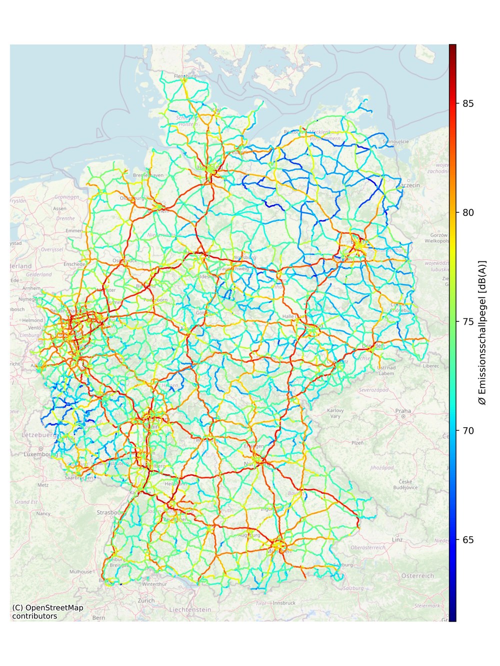
Regional noise maps for Germany and Hamburg
Noise pollution maps for road and rail transport in Germany were generated based on transport data produced within the project. This product covers all main roads in Germany and in the region of Hamburg, including the geographical information for its representation on a map. To quantify aircraft noise at different German airports, the PLATON (flight-PLAn-TO-Noise) process chain has been was developed: it facilitates the connection of air traffic data with simulated flight trajectories in order to drive sound propagation models. In this way, PLATON allows to simulate the noise levels at the airports. In ELK these simulations were conducted for 2019 and for a scenario in 2030. For the region of Hamburg, temporally-resolved maps of road and aircraft noise were generated for a representative day over a 2 × 2 km area of the city. Finally, the sound propagation for about 23,000 on-shore wind turbines in Germany was modelled. However, only the geometrical propagation was considered, as modelling the impact of topography and meteorology on sound propagation is quite complex and computationally intensive. The aim was to determine a maximum noise level for each wind turbine in Germany, which allows for a first quantification of areas potentially affected by these noise sources. Both methods and resulting noise maps developed in ELK can support urban planning measures, such as speed limits, for the sake of noise reduction. Furthermore, these methods are already being applied in the DLR project DEPA-ext., where the simulation of aircraft noise is being extended to other airports worldwide. The PLATON process chain can also be used for the validation of simplified aircraft noise calculations.
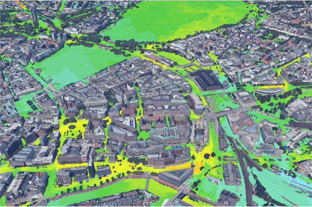
Region Hamburg: air quality maps in an urban environment
In order to model transport and air quality in Hamburg, a very detailed modelling chain was developed in ELK, which allows for highly-resolved transport and air quality simulations. In a first step, the microscopic transport models TAPAS and SUMO were adapted to the region of Hamburg, with the exact domain defined on the basis of available data. To reduce the boundary effects during the emission calculation, an additional buffer zone of about 20 km was included. Both models cover passenger transport, the transport of food, parcel and express delivery services, as well as 17 additional segments at national level provided by the macroscopic transport model DEMO. These models account for changes in public transport services and prices, travelling times and parking fees, thus allowing the assessment of different policies and future developments. The modelling results can be aggregated at different levels, like different population groups, specific vehicle segments or types, specific streets, crossings or areas of the city.
These models can be used to analyse future projections of the impact of specific measures and policies, for instance to assess supply, prices and infrastructures, changes in the sociodemographic parameters, behavior and market penetration of new driving concepts. The results are already being used to support the collaboration with local authorities of the city of Hamburg. In a second step, the local transport emissions calculated with the transport models were used to drive atmospheric model simulations for air quality. A nesting-system was developed for this purpose, combining the global-regional climate-chemistry model MECO(n) with the urban climate model PALM-4U. This facilitates the simulation of the long-range transport of pollutants across different spatial scales, which represents a significant source of pollution for the air quality at the city level. With this unique modelling system, the impact of different transport sectors on the city climate can be assessed, including the possibility of analysing future scenarios of transport and city planning under climate change and to evaluate adaptation and mitigation measures.facilitates the simulation of the long-range transport of pollutants across different spatial scales, which represents a significant source of pollution for the air quality at the city level. With this unique modelling system, the impact of different transport sectors on the city climate can be assessed, including the possibility of analysing future scenarios of transport and city planning under climate change and to evaluate adaptation and mitigation measures.
Kontakt
Prof. Dr. Anja Schmidt
Dr. Uwe Drewitz