Networks of water channels formed during the early days of Mars
February 21, 2019 | Mars Express mission
Networks of water channels formed during the early days of Mars
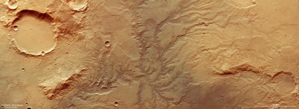
View of a heavily dendritic valley network on Mars
This image shows a system of dried-up, heavily dendritic river valleys east of the Huygens impact crater, which is over 450 kilometres in diameter. Such networks of valleys originated more than three and a half billion years ago, and therefore typically occur in the oldest, most heavily cratered regions of Mars, located in the southern highlands. The existence of such valley networks provides evidence that, at least in some periods, the planet must have had a different, most likely warmer and wetter climate, and probably even a water cycle. North is to the right in the image.
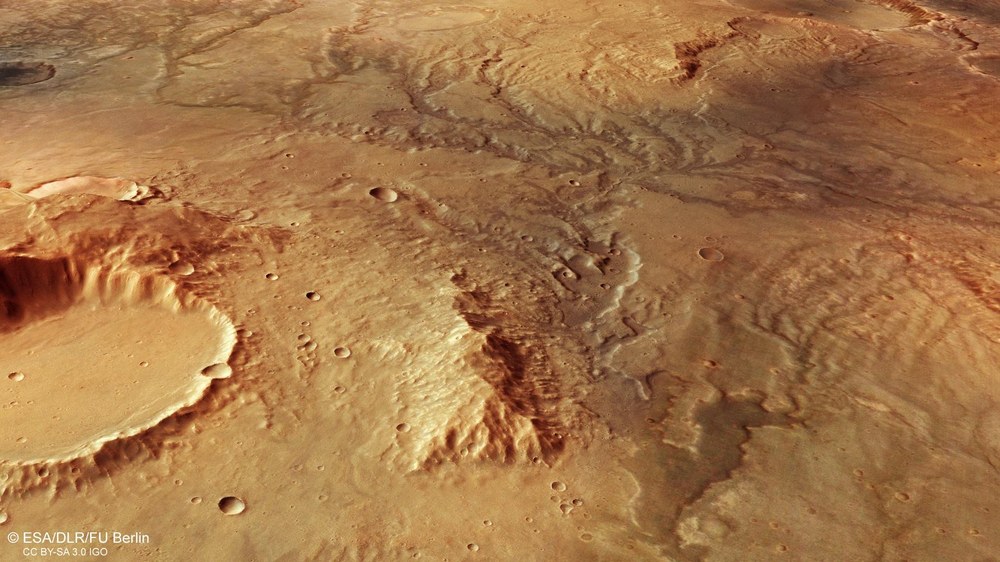
Oblique perspective view of the valley network east of Huygens Crater
This oblique perspective view was generated using data acquired by the stereo channels of the DLR-developed High Resolution Stereo Camera (HRSC). From these data, digital terrain models have been derived; these make it possible to produce perspective views of the Martian landscape. This view shows a heavily dendritic valley network east of the Huygens impact crater. The nameless crater on the left has a diameter of about 20 kilometres, the steep crater wall at the edge of the image is about 1000 metres tall. The large valley in the middle of the picture is about two kilometres wide.
Colour-coded topographic map of a valley network east of Huygens Crater
Digital terrain models of the Martian surface can be generated from the image strips acquired by the HRSC camera system, which are recorded from different viewing angles. These contain elevation information of the planet’s surface for each pixel. The level to which the elevation information is referenced is an areoid (a Martian gravitational equipotential surface). In the map, north is to the right.
The system of dried out, strongly dendritic river valleys seen in these HRSC images reveals that Mars must have had a different, probably warmer and more humid climate, at least temporarily, in the past.
Climate change is thought to have occurred on Mars some 3.7 to 3.8 billion years ago
Today, liquid water cannot be stable on the surface of Mars due to its thin atmosphere, but it still seems to be present in large quantities underground, in the form of water ice.
Focus: space, planetary research, Mars
These recent images, acquired by the High Resolution Stereo Camera (HRSC), which is carried on board the ESA Mars Express spacecraft and is operated by the German Aerospace Center (Deutsches Zentrum für Luft- und Raumfahrt; DLR), show a system of dried-up, heavily dendritic river valleys east of the Huygens impact crater. This crater is over 450 kilometres in diameter. Such networks of valleys originated more than three and a half billion years ago, and therefore are typically found in the oldest, most heavily cratered regions of Mars, located in the southern highlands. The existence of such valley networks provides evidence that, at least in some periods more than 3.7 to four billion years ago, the planet must have had a different, most likely warmer and wetter climate, and probably even a water cycle.
The systematic processing of the camera data took place at the DLR Institute for Planetary Research in Berlin-Adlershof. The working group of Planetary Science and Remote Sensing at Freie Universität Berlin used the data to create the image products shown here.
The images show a network of meandering valleys across the landscape, all of which follow a dendritic, ramified or branched pattern. In hydrology, the term 'dendritic' is derived from 'dendron' (Greek for tree) and describes a valley into which, as one moves upstream, ever-smaller side valleys open, which in turn are fed by even smaller tributaries. This results in a pattern similar to the structure of a tree, with a trunk, branches and twigs. On Earth, this erosion pattern is found in most rivers and is the result of a water cycle with precipitation, runoff, evaporation and re-precipitation. In contrast, there are very few dendritic river valleys on Mars, and they have long since dried up. Most Martian valleys exhibit a different, rather straight structure with few tributaries, and they have a different origin – because they were formed by flowing groundwater.
For such dendritic valleys to form, running water had to have been present on Mars. The various sources of this water – precipitation, groundwater or glacial meltwater – can often be determined by examining the valley structure. Martian valley networks with a dendritic layout were most likely formed by surface runoff of precipitation or meltwater. The heads of the valleys are typically located on a topographical ridge such as a watershed, and the course of the runoff channels follows the local gradient. The term ‘watershed’ refers to the boundary between two adjacent river systems, which usually extend along ridges.
As can be deduced from the colour-coded elevation model (image 6), the water flowed from north (on the right in the image) to south. The largest valleys in the images are up to two kilometres wide, and reach a depth of up to 200 metres. In particular, those that run in an east-west direction show heavily eroded valley edges, scoured by the erosive power of the water flowing down the valley. Dendritic valley systems are also found elsewhere on the crater rim and were recorded by the HRSC for the first time on 20 June 2004 during Orbit 532.
Climate change transforms Mars into a 'salty' planet
Today, it is thought that climate change took place on Mars about 3.7 to 3.8 billion years ago, when environmental conditions changed from a somewhat neutral, potentially life-sustaining and sporadically humid environment to a much more acidic, dry, cold environment that is hostile to life. The main reason for this, according to current knowledge, was the gradual loss of the Martian atmosphere and a change in the planet's volcanic activity. 'This climate change transformed our neighbouring planet from being a one with temporary rivers and lakes that was, so to speak, 'full of hope' as regards the possible emergence and development of life, into a one that was just dry and salty," explains Ralf Jaumann from the DLR Institute of Planetary Research and the Principal Investigator of the HRSC.
One of the reasons why Mars lost its atmosphere is the loss of its magnetic field, which was active during the first 500 million years. As it grew ever weaker the solar wind was able to gradually split the molecules in the atmosphere, and the resultant ions were accelerated and lost to space. As a result, and also due to the declining volcanism, the atmosphere became thinner and thinner. In addition, Mars is only half the size of Earth, so its gravitational force is barely sufficient to bind atmospheric molecules to it. Below a certain atmospheric pressure, water can no longer remain liquid on the surface of a planet – it can remain as ice or gas. The lack of precipitation on Mars ultimately collapsed the water cycle.
Is there still liquid water on the surface of Mars today?
Due to the current, very thin atmosphere, liquid water on the surface of Mars cannot be stable. Even if the temperature was favourable, it would evaporate immediately. However, beneath the surface it still seems to be abundant – in the form of water ice. The two polar ice caps on Mars also consist of a mixture of frozen water and carbon dioxide ice. Under very extreme conditions (for example, in very saline environments), liquid water could theoretically still exist for a short time on Mars.
Image processing The HRSC data for the images show here were acquired on 19 November 2018 during Mars Express orbit 18,831. The image resolution is 14 metres per pixel. The centre of the images is located at approximately 66 degrees east and 17 degrees south. The colour image was created using data from the nadir channel, which is aligned perpendicular to the surface of Mars, and from the colour channels. The oblique perspective view was generated using data from the HRSC stereo channels. The anaglyph image, which gives a three-dimensional impression of the landscape when viewed using red-blue or red-green glasses, was derived from data acquired by the nadir channel and the stereo channels. The colour-coded image is based on a Digital Terrain Model (DTM) of the region, from which the topography of the landscape can be derived. The reference body for the HRSC DTM is a Martian gravitational equipotential surface (an areoid).
HRSC on Mars Express The High Resolution Stereo Camera was developed by the German Aerospace Center (Deutsches Zentrum für Luft- und Raumfahrt; DLR) and built in collaboration with partners in industry (EADS Astrium, Lewicki Microelectronic GmbH and Jena-Optronik GmbH). The science team, which is headed by Principal Investigator (PI) Ralf Jaumann, consists of 51 co-investigators from 35 institutions in 11 countries. The camera is operated by the DLR Institute of Planetary Research in Berlin-Adlershof.

