Lowell Crater - a bullseye on Mars

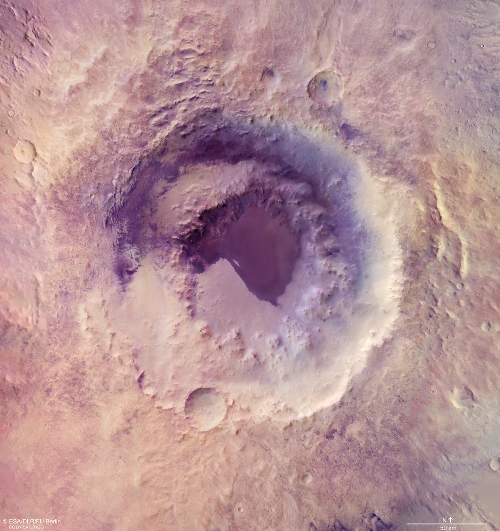
- The 200-kilometre-wide peak-ring impact crater shown in this High Resolution Stereo Camera (HRSC) image mosaic is named after the US astronomer Percival Lowell.
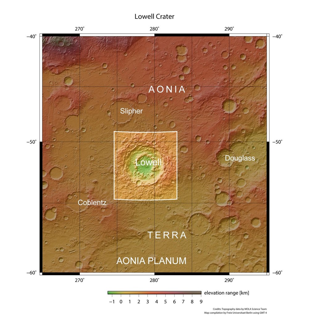
- The impact crater, which is between 3.7 and 3.9 billion years old, is located in the Aonia Terra region of the southern Martian highlands.
- Focus: Space, Planetary Research, Mars
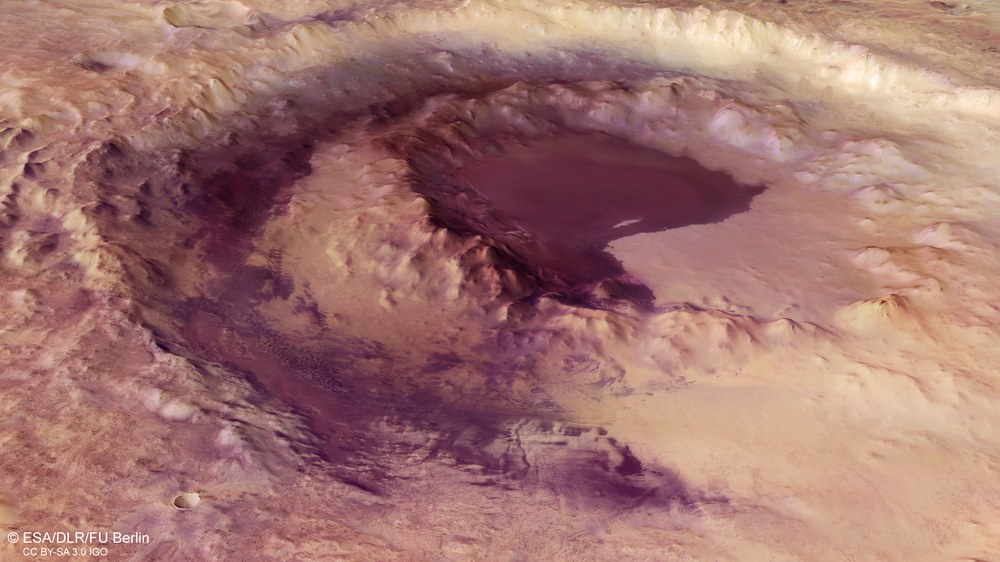
The 200-kilometre-wide peak-ring impact crater shown in this High Resolution Stereo Camera (HRSC) image mosaic is named after the US astronomer Percival Lowell (1855 - 1916). HRSC is a camera system on board ESA's Mars Express spacecraft, which has been orbiting Mars since 2003. Mars Express has flown over and imaged Lowell Crater several times in recent months. The systematic processing of the data acquired by the camera system was performed at the German Aerospace Center (Deutsches Zentrum für Luft- und Raumfahrt; DLR) Institute of Planetary Research in Berlin-Adlershof. Experts specialising in planetology and remote sensing at the Freie Universität Berlin produced the images shown here using these data.
Lowell Crater is named after the US mathematician, astronomer and writer Percival Lowell. A member of the Boston elite, in 1894 he founded the Lowell Observatory in Flagstaff, Arizona, for purposes including research into the planet Mars. Inspired by Giovanni Schiaparelli's theories about canali (canals) on Mars, Lowell advanced the idea that these were drainage channels built by an intelligent civilisation. In 1905 he predicted the existence of a 'Planet X' beyond the orbit of Neptune. His theory proved to be correct, although Pluto was only discovered in 1930, some years after his death.
The impact crater, which is between 3.7 and 3.9 billion years old, is located in the Aonia Terra region of the southern Martian highlands. Over the course of millions of years, Lowell Crater has been altered by erosion and filled with sediments that have levelled the crater floor. Dark sand dunes, gullies and channels created by water run-off are visible along the inner rim of the crater. The impact ejecta are distributed radially over an area of the crater's surroundings that extends for more than one crater diameter. There, it forms a star-shaped layer of debris that remains clearly visible in some places even today.
The bigger the crater, the more prominent its ring
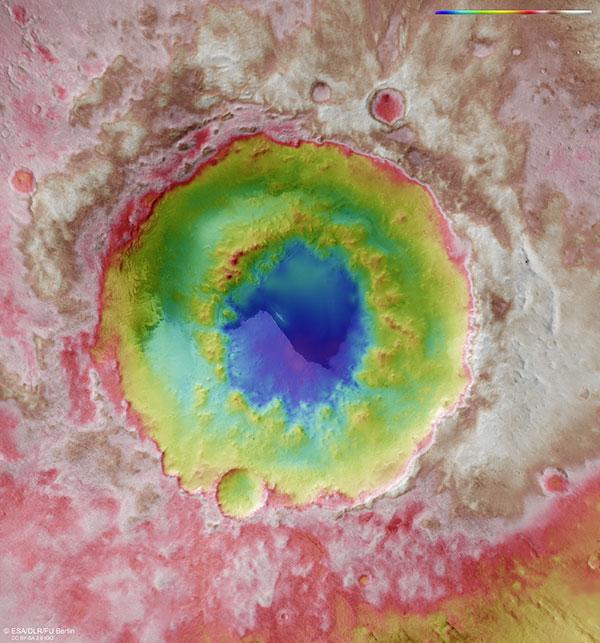
One particularly striking feature is the ring of mountains inside the impact crater, which has a diameter of 90 kilometres. This ring lies around 1.5 kilometres below the level of the surface prior to the impact. Similar peak-ring craters can be seen on Earth, Venus, Mercury and the Moon. Central mountains and rings within impact craters are caused by gravitational collapse and surface uplift during the process of crater formation, which causes a cluster of several central mountains in craters with smaller diameters, or mountains arranged in a ring within larger craters. If craters above a certain diameter collapse immediately after the impact, this results in a complex inner structure with a flat bottom, central mountains, terraces and inner rings, whereas smaller, simple impact craters have dish-shaped floors.
The transition diameter between what are referred to as simple craters and complex craters depends on the strength of the gravity on the impacted planet or moon, the nature of the substrate material and the speed of the impactor. A ring of mountains can form in the centre of complex impact craters with a diameter of over approximately 80 kilometres on Mars, or about 25 kilometres on Earth. Some scientists class such peak-ring craters to be the largest type of complex craters, while others consider them to be the smallest examples of impact basins.
Simulations and the assessment of borehole data from the approximately 200-kilometre-wide Chicxulub impact crater on the Yucatán Peninsula in Mexico have revealed that an inner ring develops when very large, unstable central mountains collapse. This means that the rocks that make up the central rings originate from deep beneath the impact site. The Chicxulub impact 66 million years ago has been linked with the mass extinction of the dinosaurs.
A dark interior
Lowell Crater has large deposits of dark sands and dune fields in its interior, which is divided into two deposition areas by its double-ringed structure. In the outer area, between the crater rim and the inner ring, it is possible to discern individual dunes, whereas the dark material within the central area is an almost fully compacted layer of sand. Only at its edges can a few separate types of dunes be identified, which are mainly transverse and longitudinal. Due to the lower quantity of sand, the outer area features mainly crescent-shaped dunes, or barchans, and barchanoid dune ridges, where barchans have merged together. The barchans on the western side often deviate from their standard form, as the topographical conditions mean that the wind tends to blow with a more circular motion, travelling around the crater ring in a clockwise direction. In places where there is more material, a slight change in wind direction quickly causes one of the horns of a barchan to become elongated on one side and then merge with downwind dunes. This results in some unusual dune shapes. The greyish-black dune sands that are common on Mars are of volcanic origin, which explains their dark colour. This indicates that they consist primarily of old, once-buried volcanic ash, which was often brought up from beneath the Martian surface by asteroid impacts, before collecting inside the crater. They have a blueish tinge in the contrast-enhanced images shown here.
Image processing
The mosaic consists of seven image strips (acquired during Mars Express orbits 2640, 2662, 2684, 16,895, 18,910, 18,977, 18,984) and covers an area from 274.5 degrees to 283 degrees east and 49 degrees to 54.5 degrees south. Orbits 18,910, 18,977 and 18,984 took place in December 2018 and January 2019. The mosaic resolution is approximately 50 metres per pixel. The colour mosaic was created using the nadir channel and colour channel data from the individual image strips. The nadir channel of HRSC is directed perpendicular to the surface of Mars. The oblique perspective view was computed from data acquired by the HRSC stereo channels. The colour-coded view is based on a Digital Terrain Model (DTM) of the region, from which the topography of the landscape can be derived. The reference body for the HRSC DTM is a Martian equipotential surface (Areoid.)
The HRSC experiment on Mars Express
The High Resolution Stereo Camera was developed by the German Aerospace Center (Deutsches Zentrum für Luft- und Raumfahrt; DLR) and built in collaboration with partners in industry (EADS Astrium, Lewicki Microelectronic GmbH and Jena-Optronik GmbH). The science team, which is headed by Principal Investigator (PI) Ralf Jaumann, consists of 51 co-investigators from 35 institutions in 11 countries. The camera is operated by the DLR Institute of Planetary Research in Berlin-Adlershof.