Moreux Crater on Mars – dunes and evidence of glacial processes
March 5, 2020 | Mars Express mission
Moreux Crater on Mars – dunes and evidence of glacial processes
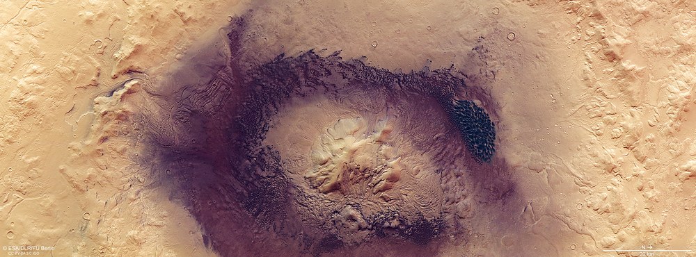
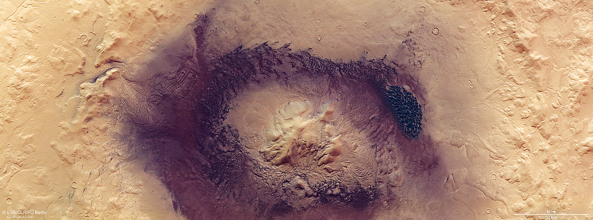
Colour plan view of Moreux Crater in Protonilus Mensae
The crater, which is approximately 135 kilometres across, has been heavily eroded and changed by glacial processes. This is particularly visible on the rim and central peak. Its floor has been so deeply filled that the crater now only has a depth of around three-and-a-half kilometres. A belt of dark dunes forms a circle around the central peak. In these contrast-enhanced colour images, the dune sands appear bluish.
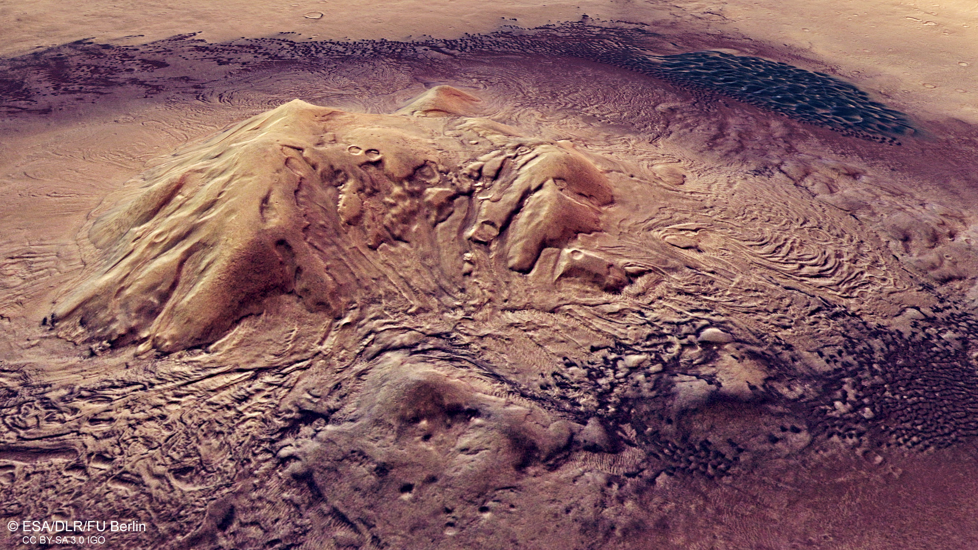
Perspective view of the central peak in Moreux Crater
A central peak that has been heavily modified by glacial processes rises two kilometres from the floor of Moreux Crater. The formation of central peaks in impact craters is determined by gravity, the impact speed and – above a certain value – the size of the impactor. They are mainly found in craters with diameters in excess of around 100 kilometres. The large dune field of barchanoidal ridges can be seen to the northwest of the peak (upper right, in the background). Numerous individual sickle dunes (barchans) are distributed in a ring on the crater floor. In this contrast-enhanced colour image, the black-grey dune sands appear bluish.
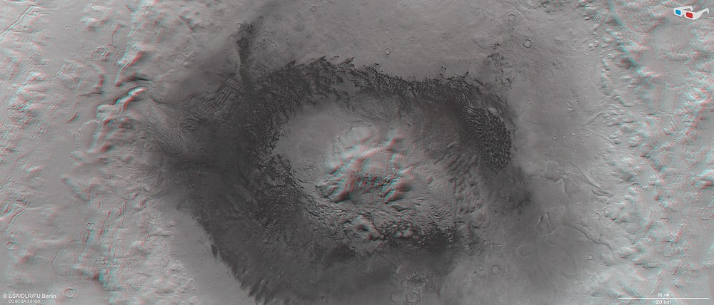
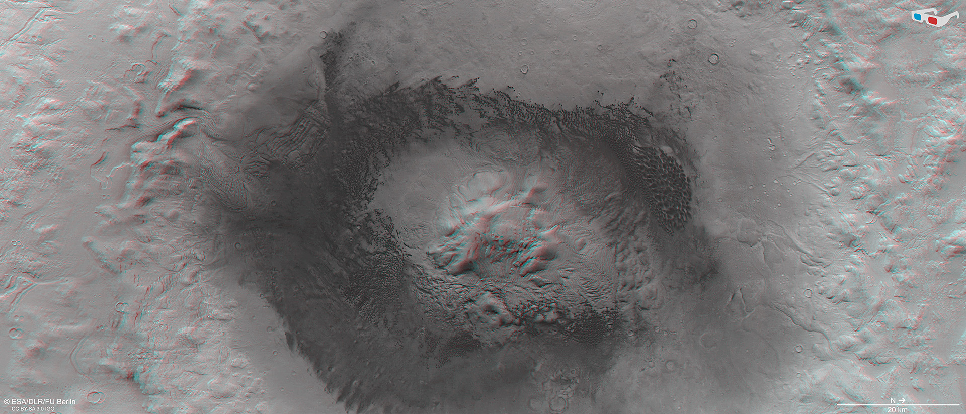
3D view of the Moreux impact crater in Protonilus Mensae
Anaglyph images can be generated from data acquired by the nadir channel of the High Resolution Camera System (HRSC), which is directed perpendicularly to the surface of Mars, and one of the four obliquely viewing stereo channels. When using red-blue or red-green glasses, they provide a realistic, three-dimensional view of the landscape. North is on the right of the image. The impact crater, which is approximately 135 kilometres across, has a depth of up to 3500 metres. The central peak is about 2000 meters high.
Moreux Crater is located in Protonilus Mensae on the border between the Martian highlands and lowlands. Extensive deposits of ground ice exist in this region.
Ice-rich material has left many traces, particularly around the central peak and along the crater rim. Analyses of the terrain indicate that these glacial processes have continued until very recently.
A range of dune formations can also be seen inside the crater, allowing the prevailing wind directions to be determined.
Space, planetary research
The images shown here, which were acquired by the High Resolution Stereo Camera (HRSC) on board ESA's Mars Express orbiter, reveal the impressive Moreux Crater on Mars. Glaciers have left their mark on the crater rim and floor, and have significantly altered the terrain. This striking view is complemented by a number of distinctive dark dunes. These formations bear witness to the influence of the prevailing wind systems.
HRSC was developed and is operated by the German Aerospace Center (Deutsches Zentrum für Luft- und Raumfahrt; DLR). The systematic processing of the camera data was carried out at the DLR Institute of Planetary Research in Berlin-Adlershof. The image products shown here were created at the Department of Planetary Sciences and Remote Sensing at the Freie Universität Berlin.
Moreux Crater has a diameter of approximately 135 kilometres and is up to three-and-a-half kilometres deep. It is located in Protonilus Mensae, which lies on the Martian dichotomy boundary. The region has extensive deposits of ground ice, as well as surface ice and snow. The floor of the crater is mostly covered by dark dune fields, which are common on Mars.
Formed by glaciers …
Ice-rich material has left behind a diverse glacial treasure trove, which can be found mainly around the central peak and along the crater rim. This includes numerous valleys that carve into the flanks. Polygonal structures at the bottom of these valleys have been interpreted as patterned ground, or periglacial landforms. Linear valley fillings, such as in the wide valley at the southern crater rim (Image 3), were created by the meeting of ice and scree masses that once slid down the valley slopes and met in the middle of the valley. Tongue-shaped deposits and viscous flow patterns are remnants of rock glaciers that formed almost everywhere along the crater wall.
Dating of these terrain forms has revealed that glacial and periglacial processes occurred here repeatedly during a period that lasted from approximately one billion to 400,000 years ago. Moreux Crater is situated at 41.6 degrees north, in the mid-latitudes of Mars, where glaciation processes occurred mainly when the axis of rotation of Mars was tilted at a greater angle than it is today (currently the inclination is 25.2 degrees) and the poles, with their ice caps, were tilted more directly towards to the Sun. Then, at mid-latitudes, more ice and snow from the atmosphere was deposited on crater edges and plateaus, where it collected and formed glaciers.
… and gone with the wind
The two-kilometre-high central peak in the crater is surrounded by dark, sandy material. Winds have piled it up into groups of individual dunes and also into contiguous dune fields. The grey-black dunes (they only appear bluish in these contrast-enhanced colour images) consist of volcanic sand and fine ash with a basalt composition. This is mainly comprised of the minerals olivine and pyroxene, which cause the dark colouring of basaltic materials. Both minerals are silicates and have a high content of magnesium and iron.
The dune fields in Moreux Crater show slight colour variations, possibly caused by differences in the composition of the dunes. The OMEGA spectrometer on Mars Express can be used to investigate the mineralogical composition of surface materials. The large contiguous dune field to the north of the central peak (right in Image 1) was found to have a significantly higher olivine content than the rest of the dunes, which are predominantly composed of pyroxene.
In addition to the glacial formations, the crater also has aeolian formations that are visible in the different dune shapes. The most common type of dune is crescent-shaped (referred to as a barchan) which, when they grow together and merge, form barchanoidal ridges. The dune fields in Moreux Crater are made up of these ridges. Barchans are generally associated with limited sediment availability and a unimodal wind regime – this is, they are formed by wind that always blows from the same direction.
However, orientation of the dunes varies in different regions of the crater, which indicates a complex system of prevailing wind directions. This is due to the specific topography of the crater and its central peak. The large barchanoidal dune field to the north of the central peak is primarily formed by winds from the northeast. At its southern end, winds from the northwest meet the dunes and create star dunes, which are typically formed by winds from different directions.
If one follows the dune shapes counterclockwise from there, around the central peak, and uses them to discern the wind directions, the winds follow a semicircle. First, they come from the northwest, then the west, and later from the southwest until one reaches the eastern side of the dune ring (bottom of Image 1). Here, downdrafts from the west blowing from the slopes of the central peak meet winds from the east coming from the crater rim. The barchanoidal ridges change into transverse dunes at this point. Moreux Crater is thus a prime example of how local topography can influence wind flows and thereby have an indirect influence on morphological features.
Image processing
The images shown here were acquired by the High Resolution Stereo Camera (HRSC) on 30 October 2019 during Mars Express orbit 20,014. The image resolution is approximately 16 metres per pixel. The centre of the image is at about 44 degrees east and 42 degrees north. The perpendicular colour view was generated from the data acquired by the HRSC nadir channel, which is directed perpendicular to the Martian surface, and the colour channels. The oblique perspective views were computed using a Digital Terrain Model (DTM) and data from the nadir and colour channels of HRSC. The anaglyph image, which gives a three-dimensional impression of the landscape when viewed with red-blue or red-green glasses, was derived from data acquired by the nadir channel and the stereo channels. The colour-coded image map is based on a DTM of the region, from which the topography of the landscape can be derived. The reference body for the HRSC DTM is an equipotential surface of Mars (areoid).
The HRSC experiment on Mars Express
The High Resolution Stereo Camera (HRSC) was developed by the German Aerospace Center (Deutsches Zentrum für Luft- und Raumfahrt; DLR) and built in collaboration with partners in industry (EADS Astrium, Lewicki Microelectronic GmbH and Jena-Optronik GmbH). The science team, which is headed by Principal Investigator (PI) Ralf Jaumann, consists of 52 co-investigators from 34 institutions in 11 countries. The camera is operated by the DLR Institute of Planetary Research in Berlin-Adlershof.

