Nectaris Fossae and Protva Valles – faults and valleys on a volcanic highland plateau
January 31, 2023 | Mars Express mission
Nectaris Fossae and Protva Valles – faults and valleys on a volcanic highland plateau
Nectaris Fossae and Protva Valles
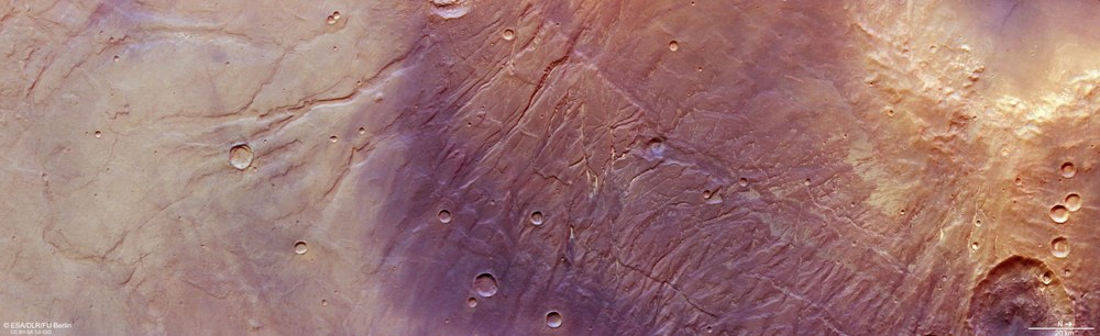
This image shows the eastern flank of the Coprates Ridge in the Thaumasia region, an extensive volcanic plateau several thousand metres thick. The plain in the left third of the picture is approximately 2500 metres lower than the areas in the right third of the picture. The rugged mountains on the right edge of the picture are an additional 2000 metres higher. North is to the right of the image. Straight grabens, the Nectaris Fossae, indicate tectonic extensional structures, while the broad, winding and often already heavily eroded valley courses of the Protva Valles testify to the former presence of flowing water. Presumably, the landscape has changed little over three and a half billion years. The region shown is approximately 330 by 100 kilometres and covers an area as large as the German state of Baden-Württemberg.
South of the Valles Marineris valley system, which runs from west to east, runs the parallel chain of collapsing calderas of the Coprates Catena (beyond the image). From there, several hundred kilometres to the south, the Coprates Ridge extends, the highest points of which can be seen in this perspective view. The mountain range separates the volcanic Thaumasia Plateau in the west from the Noachis Terra plain several thousand metres below in the east. A section of Ibragimov Crater can be seen in the foreground.
Anaglyph images can be generated from data acquired by the nadir channel of the DLR-operated HRSC camera system on ESA's Mars Express spacecraft, which is directed perpendicularly to the surface of Mars, and one of the four oblique stereo channels. When used with red-blue or red-green glasses, they allow a three-dimensional view of the landscape and give the viewer a spatial idea of the differences in altitude. In this way, many of the geological structures described can be better understood than in the vertical plan view.
Image data acquired by the HRSC camera on board the Mars Express spacecraft reveal a geologically complex region on the flanks of Thaumasia Planum.
The images show the eastern flank of the Coprates Ridge.
This contains tectonic fault structures of the Nectaris Fossae as well as the wide valleys of the dried-up Protva Valles river system.
The High Resolution Stereo Camera (HRSC) is an experiment developed by DLR that has been sending images of the Martian surface to Earth since January 2004.
Focus: Space exploration
January's 'Mars Image of the Month' reveals a geologically complex region on the flanks of Thaumasia Planum, an extensive volcanic plateau in the highlands southeast of the Valles Marineris valley system. The image data was acquired using the High Resolution Stereo Camera (HRSC) on board ESA’s Mars Express mission. HRSC is a camera experiment developed and operated by the German Aerospace Center (Deutsches Zentrum für Luft- und Raumfahrt; DLR). As of January 2023, the HRSC has been in operation for 19 years and remains fully functional.
Thaumasia Planum is a large volcanic highland plateau south of the deep canyons Melas and Coprates Chasma – two tectonic fault structures that are part of the vast, 4000-kilometre-long Valles Marineris valley system. The 'Plain of Thaumas' is named after a sea god in Greek mythology and consists largely of solidified lava flows. These flows are up to several thousand metres thick, much thicker than anything found on the continents of Earth. The lava probably erupted during the Noachian period, the oldest of the three Martian geological eras. It is therefore approximately four billion years old. Thaumasia is bordered on the east by a 900-kilometre-long ridge running north to south, informally referred to as Coprates Ridge.
The HRSC images presented here show the eastern flank of the Coprates Ridge, which contains tectonic fault structures of the Nectaris Fossae as well as the wide valleys of the dried-up Protva Valles river system. The topography indicates massive alteration of the landscape due to movements in the Martian crust, which resulted in the formation of the tectonic grabens, and subsequent erosion. Some landforms are the result of outflowing lava that then solidified into a thin layer, creating what are referred to as wrinkled ridges (see annotated image and overview map).
Magma bubbles formed large parts of the Martian crust
The formation of the Nectaris Fossae probably began in the Noachian era and possibly continued into the following Martian age – the late Hesperian – when Mars increasingly took on its present shape. The grabens are thought to be 'genetically' linked to the Valles Marineris system, that is, they were formed by stretching of the crust due to uplift caused by rising magma bubbles. In this HRSC observation, the fissures cut almost straight through the image and are often filled with brightly coloured dust or sand.
The valley network of Protva Valles is heavily weathered by erosion. Its origin has been dated to the late Noachian and early Hesperian periods – a time when much more water flowed over the surface of Mars, carrying eroded material and reshaping the surface.
The development of the region may have begun with the uplift from the mass of the Tharsis volcanoes, which are up to 20 kilometres high, and the Olympus Mons megavolcano. This uplift may have caused stresses in the rock crust and led to numerous extensional fractures. Afterwards, the region was repeatedly covered by basalt lava flows, the most common volcanic rock on Earth as well, consisting of a thin layer of lava rich in iron and magnesium. During a later phase, the region was covered by volcanic ash and dust. Eventually, run-off water eroded valleys into the landscape.
Where did the water come from?
Some of the valleys appear to be cut deeper into the rock, others are more shallow and wider. They also seem to originate at different elevation levels – an indication of a lowering of the groundwater table if the rivers were fed by escaping groundwater. However, due to severe erosion, it is difficult to determine the origin of the water. The height differences within this image are an impressive 4500 metres. This is a scale that is only seen on Earth when considering the highest mountain ranges, the Andes and the Himalayas. However, since Protva Valles was probably formed 3.8 billion years ago, the geology has changed little.
Image processing
The images were created using data acquired by the High Resolution Stereo Camera (HRSC) on 23 May 2022 during Mars Express orbit 23,232. The ground resolution is approximately 23 metres per pixel and the image is centred at about 301 degrees east and 27 degrees south.
The colour image was created using data acquired by the nadir channel, the field of view of which is aligned perpendicular to the surface of Mars, and the colour channels of the HRSC. The oblique perspective view was generated using a Digital Terrain Model (DTM) and data acquired by the nadir channel and colour channels of the HRSC. The anaglyph image, which creates a three-dimensional impression of the landscape when viewed with red/blue or red/green glasses, was derived from data acquired by the nadir channel and one of the stereo channels.
The colour-coded topographic view is based on a DTM of the region, from which the topography of the landscape can be derived. The reference body for the HRSC DTM is a Mars equipotential surface (Areoid).
HRSC is a camera experiment developed and operated by the German Aerospace Center (DLR). The systematic processing of the camera data was carried out at the DLR Institute of Planetary Research. Personnel in the Department of Planetary Sciences and Remote Sensing at the Freie Universität Berlin used these data to create the image products shown here.
The High Resolution Stereo Camera (HRSC) was developed at the German Aerospace Center (DLR) and built in cooperation with industrial partners (EADS Astrium, Lewicki Microelectronic GmbH and Jena-Optronik GmbH). The science team, led by Principal Investigator (PI) Dr Thomas Roatsch of the DLR Institute of Planetary Research, consists of 52 co-investigators from 34 institutions and 11 nations. The camera is operated by the DLR Institute of Planetary Research in Berlin-Adlershof.


