Test flights over Bavaria inform upcoming Earth‑observation space missions
July 24, 2025 | CROPEX25 measurement campaign for European environmental monitoring completed
Test flights over Bavaria inform upcoming Earth‑observation space missions
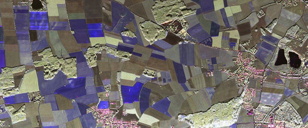
X-band radar image of the Puch test area
Polarimetric radar data acquired as part of the CROPEX25 campaign (shown here in the X-band, with a wavelength of three centimetres) allow images to be coloured-coded according to their physical properties. Blue indicates surface scattering, for example from a freshly sown field. Red indicates double-bounce scattering, for example from building walls and the ground. Green marks areas of volumetric multiple scattering, such as a grain field or forest canopies.
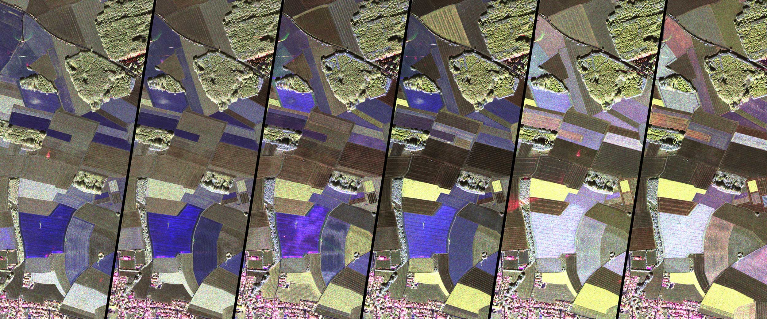
This radar mosaic of the Bavarian test region of Puch shows the development of vegetation from April to July 2025 at approximately two-week intervals (left to right). Each panel shows a radar image of the same region in the X-band. The changing colours of the fields over time are clearly visible, providing a clear signal that the condition of the soil and vegetation has changed due to ground cover and plant growth.
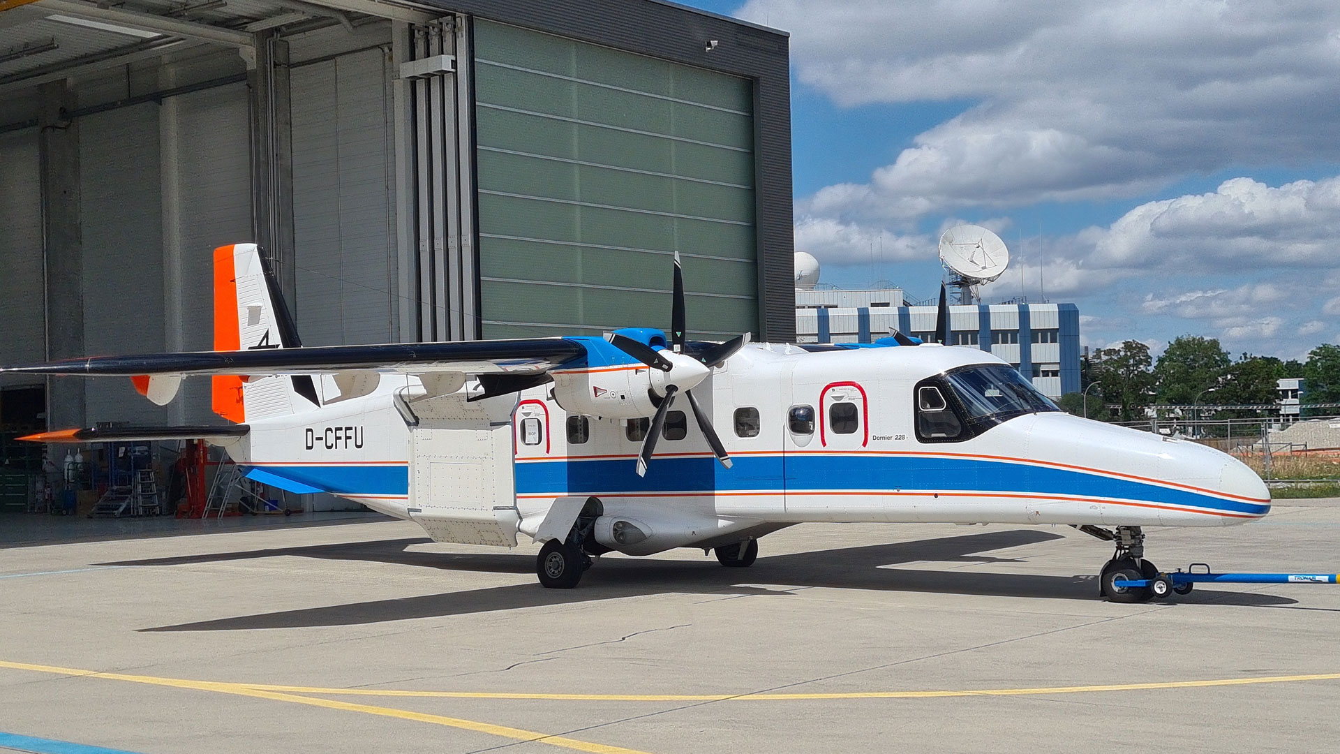
DLR's Dornier Do 228-212 D-CFFU with installed F-SAR
The Dornier Do 228-212 research aircraft (registration D-CFFU) with the F-SAR system installed. The radar system is housed in the cabin, while the antennas for the various wavelengths (X, C, S and L bands) are mounted on the right side of the fuselage.
Interdisciplinary research teams have conducted extensive aircraft, ground and satellite measurements near Munich, Germany, providing important data to prepare the ROSE-L and CHIME environmental missions.
On behalf of ESA, DLR coordinated the four-month CROPEX25 measurement campaign.
The results will help advance analysis methods for agricultural Earth-observation data and make an important contribution to global food security and sustainability.
How healthy is our soil – and how can early changes be detected? In spring and summer 2025, the German Aerospace Center (Deutsches Zentrum für Luft- und Raumfahrt; DLR) teamed up with various research institutions to investigate these questions over the Puch region near Munich, Germany. As part of the CROPEX25 measurement campaign, research aircraft regularly flew over agricultural areas throughout an entire growing season, while state-of-the-art sensors, radar and camera systems took measurements on the ground. CROPEX25 is part of preparations for the European Copernicus Earth observation missions ROSE-L and CHIME. The aim is to provide support for agriculture from space even more effectively, for example through mapping soil moisture, biomass and vegetation cover worldwide.
The campaign was coordinated by DLR's Microwaves and Radar Institute in cooperation with the European Space Agency (ESA). The Ludwig Maximilian University (LMU) in Munich and the GFZ Helmholtz Centre for Geosciences were also involved. In parallel and complimentary to this, DLR's Earth Observation Center (EOC) took hyperspectral images with its HySpex camera system and carried out weekly drone surveys as well as spectral measurements of the ground and atmosphere.
Tomorrow's satellite data – tested today
The CROPEX25 measurements focused on the high-performance, airborne FSAR radar system from DLR's Microwaves and Radar Institute. Researchers flew over the test area every six days – matching the planned flyovers of the ROSE-L satellite, which is scheduled for launch in early 2029. F-SAR recorded a globally unique dataset across four different frequency ranges (the X, C, S and L bands). In total, the radar team carried out 23 measurement flights. On selected days, the flights took place in the morning, at midday and in the evening to record any daily changes in the soil and vegetation.
The data was collected using innovative imaging techniques such as polarimetry, interferometry and tomography. Experienced DLR test pilots flew specified paths with metre-level precision, supported by the satellite-based navigation system integrated into the F-SAR. Parallel to each flight, a team from LMU collected ground measurements of soil and vegetation parameters, such as soil moisture, surface roughness, plant water content and plant biomass. The radar measurement flights used DLR’s Dornier Do 228-212 research aircraft, operated by the DLR Flight Experiments Facility in Oberpfaffenhofen and specially modified for this purpose.
Deeper insight through diverse data
GFZ researchers also collected soil samples to analyse their organic and mineral composition. In a wheat field, a special ESA scatterometer was used to automatically and continuously record changes in plant structure. In addition, multi- and hyperspectral sensors from DLR’s Earth Observation Center were also used. DLR's Cessna 208B Grand Caravan research aircraft, equipped with the HySpex camera system, provided important reference data for existing satellites such as Sentinel-2, EnMAP, DESIS and PRISMA. Using the hyperspectral images from HySpex, researchers can derive important biophysical parameters, in particular above-ground biomass, fractional vegetation cover and soil moisture. DLR Earth observation specialists are further developing evaluation methods for the upcoming CHIME satellite mission with this new data.
The agricultural region around Puch, near Munich, served as the test area for the measurement campaign. Puch comprises a few villages, some wooded areas and is more than 80 percent agricultural farmland. Fifteen fields representing different crop types were selected, ensuring comprehensive measurements. Most of the fields belong to the Bayerische Staatsgüter (Bavarian State Farms) – a state enterprise of the Free State of Bavaria, which authorised the data collection.
Scientific cooperation is key
CROPEX25 demonstrates the importance of interdisciplinary cooperation in environmental research. The teams involved combined their data to create a detailed picture of plant and soil conditions. Together, they developed new analysis methods that will help identify environmental risks at an early stage and promote sustainable agriculture. The new, comprehensive datasets reflect this close and interdisciplinary cooperation between research teams.
In view of global environmental changes, there is an urgent need for high-performance satellite systems that can document the condition of agricultural land and provide information about crop health. With the successful completion of the CROPEX25 campaign, DLR has made a decisive contribution to preparing the next generation of environmental satellites – another step towards precise, global Earth observation.
The European Copernicus Earth observation mission ROSE-L (Radar Observation System for Europe in L-band) will monitor critical environmental changes from space. The satellite is scheduled to launch in 2029 and its radar data will significantly improve the monitoring of European geohazards and surface movements. ROSE-L will support improved forest-management mapping and provide important information for agriculture and food security. Thanks to long-wavelength L-band measurements, the mission will – among other capabilities – classify global land cover, determine soil moisture content and detect land subsidence. ROSE-L will also acquire data over the seas and contribute to Arctic monitoring by providing new information on sea ice, icebergs, glaciers and ice caps.
Contact
Bernadette Jung
Communications and Media Relations: Oberpfaffenhofen, Augsburg, Weilheim


