Cosmic scarring in radar view


There are just 188 known meteorite craters worldwide. Some span a mere 10 metres, while others extend across 160 kilometres and are significantly more impressive. They all share a common history – an object from outer space must hit the Earth travelling at least 11 kilometres per second, or 39,000 kilometres per hour, to leave behind an impact crater. "They can all look very different. Frequently they are aged, or even contain subterranean lakes," says Manfred Gottwald, a scientist at the German Aerospace Center (Deutsches Zentrum für Luft- und Raumfahrt; DLR) Earth Observation Center. He has seen almost all of them – not in person, but through the eyes of the two German radar satellites TerraSAR-X and TanDEM-X. DLR uses their data to produce three-dimensional elevation models in previously unseen precision. The subjects include the Aorounga structure in Chad as well as the Tin Bider crater in Algeria, the Shunak impact in Kazakhstan and the Ries Crater in Germany.
Sculptures in sunlight
"First of all, we want to learn what already known meteorite craters will look like in the 3-D elevation model produced by our radar satellites”, explains Gottwald. Their vantage point roughly 500 kilometres above Earth's surface detects even the most remote crater. The radar satellites TerraSAR-X and TanDEM-X, which have circled the Earth in formation flight since 2010, also have the advantage that – unlike optical satellites – they can map the surface of the Earth irrespective of cloud coverage or lighting. Therefore, craters dispersed around the world can, for the first time, be tracked down and compared as part of a uniform, global elevation model. Artificial lighting, in which the scientists define the solar elevation and angle, is added to depict the various impact craters in a particularly sculptural form. Then, the shadows cast, in combination with the elevation model, permit very clear outlines of the crater edges, faults and erosion phenomena to be displayed.
The image acquisitions required for the new 3-D image of the Earth are now complete, which means that the two radar satellites are currently being used for a broad variety of scientific analyses. This phase of the project will run until the end of the year, focussing primarily on research in the fields of geology, hydrology, glaciology, agrarian science, forestry and urban land use. It will also involve the testing of new radar technology.
So far, the scientists at DLR have processed over 450,000 individual images in order to produce the three-dimensional elevation model with a vertical precision of better than two metres. Sixty-five percent of the Earth's land mass has already been rendered in 3-D. "Our elevation model provides a wealth of information on the impact craters, for instance their exact size and state of preservation. It also allows mapping of entire craters, even if parts of their visible sections are hidden beneath vegetation."
Stereotypes of beautiful craters…
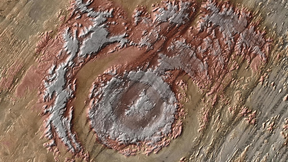
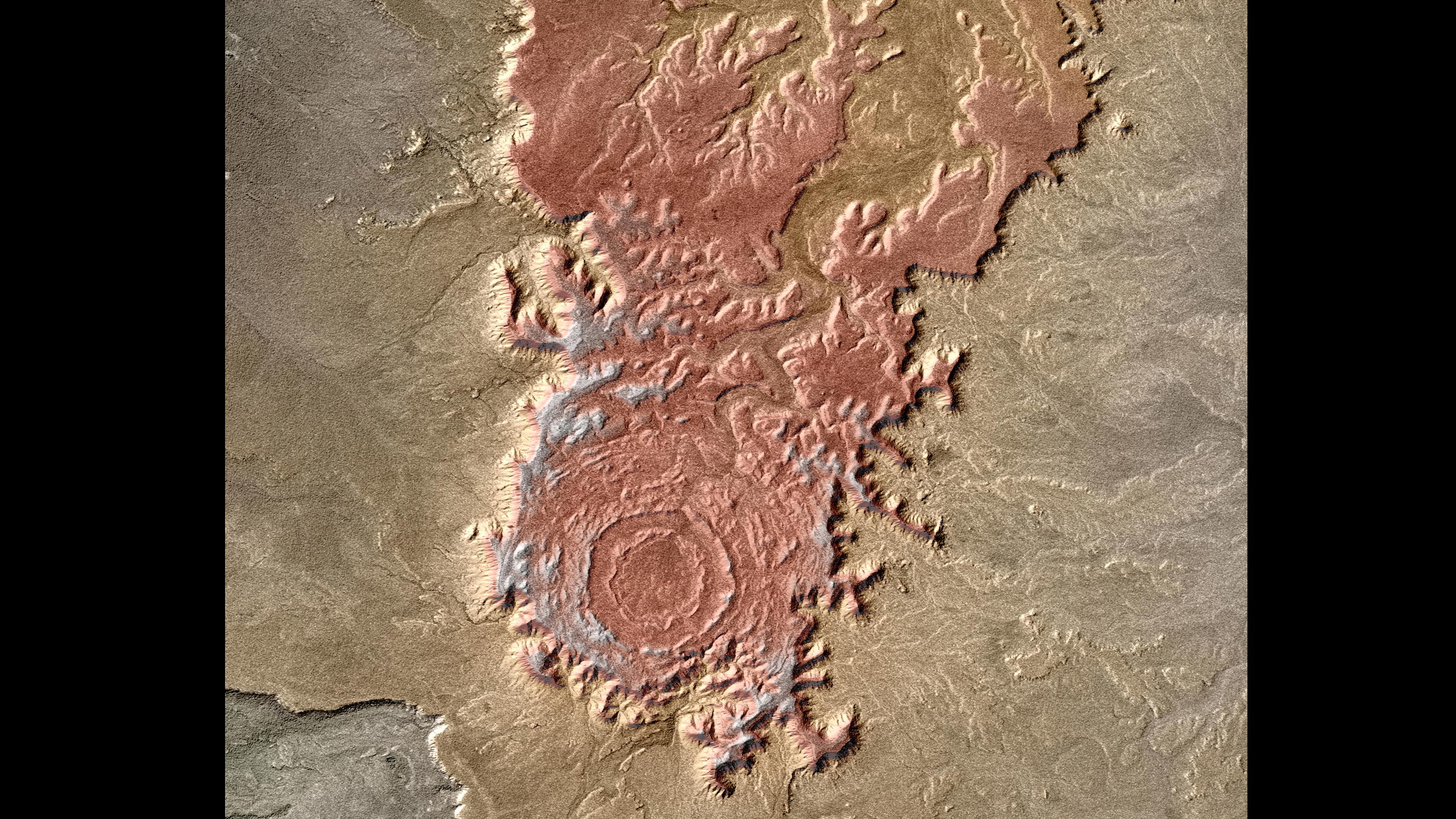
One stereotypical cosmic impact crater is situated in the American state of Arizona; the Barringer Crater is a prominent feature of the semi-desert plains. It has a diameter of 1.2 kilometres and is among the best-researched legacies of a cosmic visitor. The object that created it was almost 50 metres across and collided with Earth some 49,000 years ago, travelling at a speed of between 12 and 20 kilometres per second. The Shunak structure in Kazakhstan looks quite similar when viewed from space. Its roughly 400-metre-high crater edge stands out in the TanDEM-X elevation model, despite being concealed in an undulating landscape. Measuring 2.8 kilometres across, scientists conjecture that the Shunak Crater was formed roughly 45 million years ago.
… through to unusual crater forms
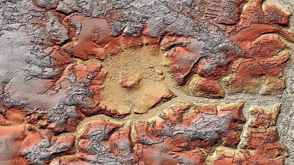
Nevertheless, not all impact sites do the scientists the favour of looking like typical craters. The Aorounga structure in the North African country of Chad is likely around 345 million years old, and is therefore extremely weathered. The outer and inner rings are both visible, especially from space. Here, the strong winds have acted as builders, carving parallel structures into the ground; they consist of wind-resistant, rocky protuberances, referred to as yardangs, through which the sand dunes meander, carried by the wind. The Tin Bider impact basin in the Algerian part of the Sahara Desert towers above the surrounding landscape, as if to go against the collected stereotypes relating to craters. It consists of various rocky strata that, across the passage of time, have experienced different degrees of erosion.
An object of interest on the doorstep
The DLR scientist Manfred Gottwald has a particular penchant for a crater found 'almost on his doorstep'; the Ries Crater on the border between Swabia and Franconian Jura regions. The repercussions were dramatic when an asteroid measuring one kilometre across crashed to Earth here 14.8 million years ago. The borders of the crater, which initially extended 10 kilometres across, started to slide, expanding its size to 24 kilometres. The elevations on the inside of the crater basin collapsed, producing another, smaller ring. A layer of impact ejecta covered the ground across a circumference of 40 kilometres, and is up to 100 metres deep in places. A lake filled the basin for several million years. Now, the digital elevation model produced by the two radar satellites provides the clearest possible image of what remains today of this former crater.
The tricky search for unknown craters
For now, the DLR scientists only have their eyes on known craters. "At a later stage, we would like to use the information provided by our radar satellites to search for currently unidentified craters in a variety of selected regions – but that is extremely tricky," emphasises Gottwald. This is why he cooperates with geologists from the University of Freiburg and the Museum für Naturkunde in Berlin, among others. "Ultimately, only conducting on-site analyses of the rocks can confirm whether a formation is indeed an impact crater." Here, DLR provides a terrain model of such accuracy that not only delivers indications of possible impact sites, it also helps to plan and conduct the frequently arduous expeditions to the areas in question.
The TanDEM-X mission
TanDEM-X is a Public Private Partnership (PPP) project conducted jointly by DLR and Airbus Defence and Space (formerly Astrium). DLR is responsible for providing TanDEM-X data to the scientific community, mission planning and implementation, radar operation, calibration and control of the two satellites, and generation of the digital elevation model. To this end, DLR has developed the necessary ground-based facilities. The DLR Microwaves and Radar Institute, the DLR Earth Observation Center and DLR Space Operations in Oberpfaffenhofen are responsible for developing and operating the ground-based facilities for TerraSAR-X and TanDEM-X. The project's scientific coordination has been entrusted to the DLR Microwaves and Radar Institute. Airbus Defence and Space built the satellite and shares the cost of its development and use. The company is also responsible for commercial marketing of the TanDEM-X data.