Peering through smoke – DLR satellite TET-1 delivers detailed images of the fires in Indonesia


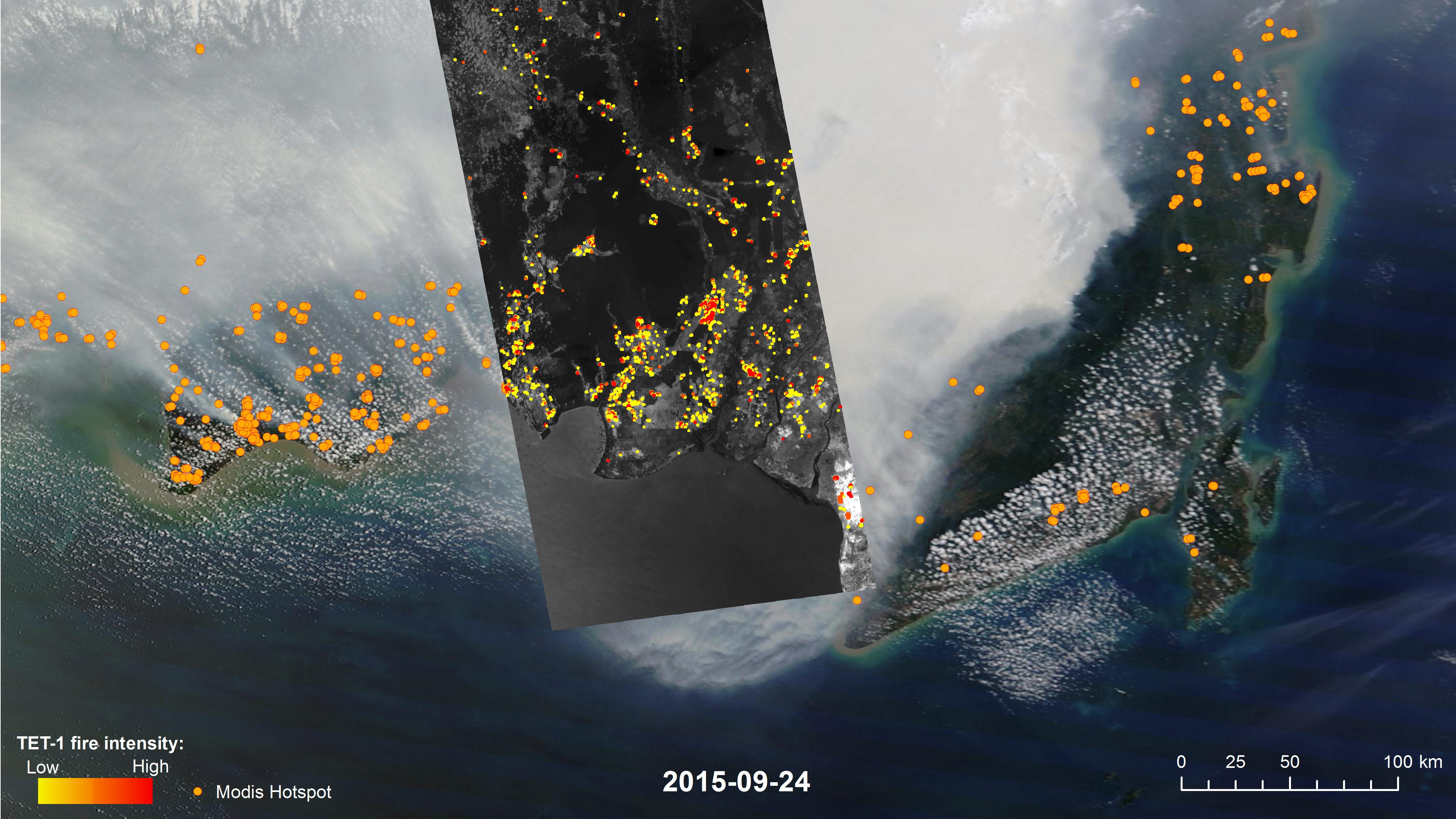
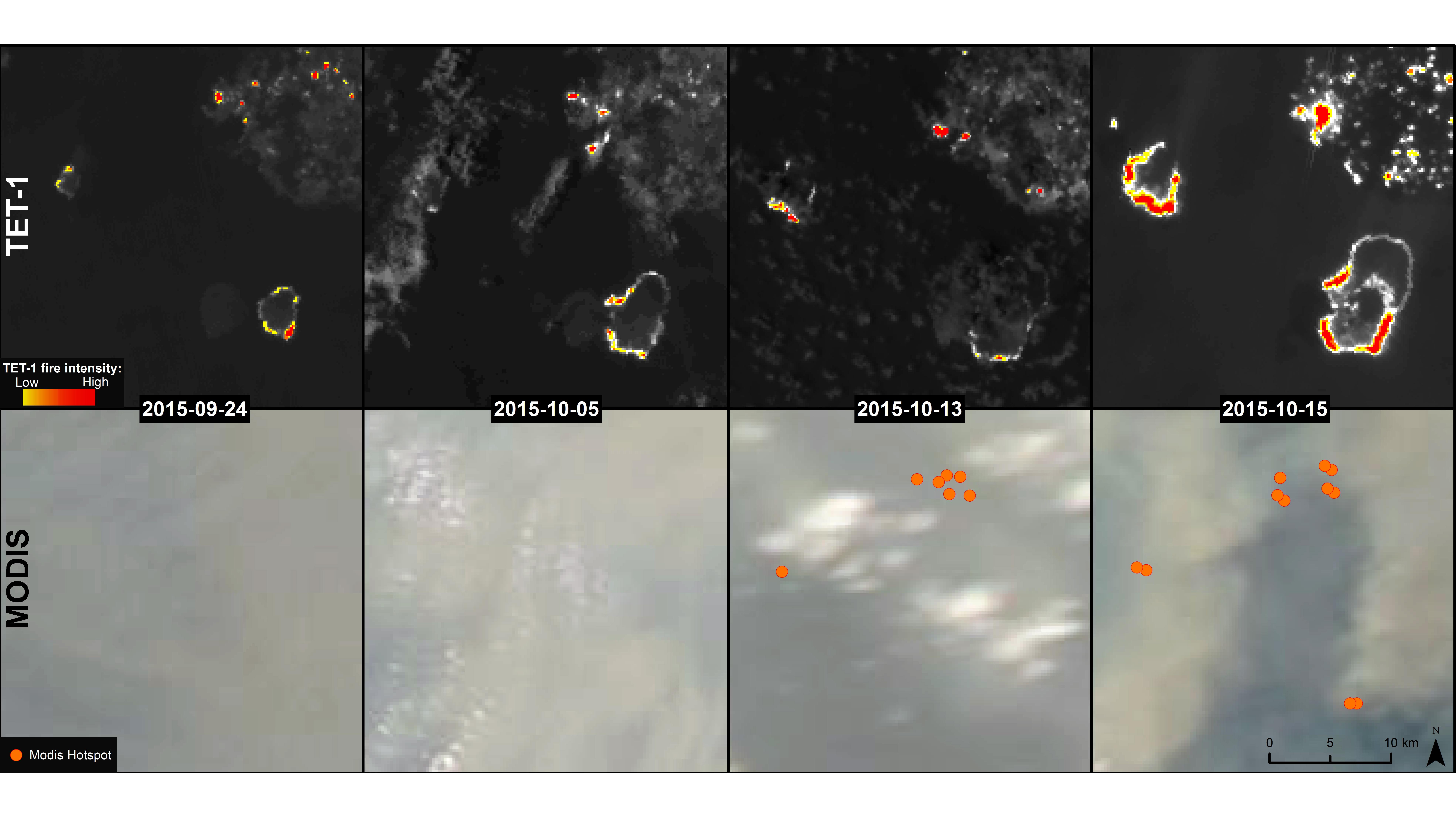
Indonesia is on fire – the island state is currently facing a bitter struggle against forest and peat fires on Sumatra and Borneo, most likely caused by illegal 'slash and burn' farming to clear the land for palm oil or timber plantations. The extremely dry conditions resulting from the El Niño weather phenomenon exacerbate this problem. Reliable information on the source and spread of the fires is needed to initiate suitable countermeasures and to estimate the environmental consequences. Although satellite images can provide this information, the thick clouds of smoke concealing the exact locations of the fires often prevent them from delivering sharp pictures. This is why the microsatellite TET-1 (Technologieerprobungsträger-1; Technology Testbed-1), built by the German Aerospace Center (Deutsches Zentrum für Luft-und Raumfahrt; DLR), has been deployed. "The high sensitivity and spatial resolution of the camera installed on TET allows us to detect and monitor very small fires, even through thick smoke," says Eckehard Lorenz from the DLR Institute of Optical Sensor Systems and Principal Investigator of the mission, who was involved in the development of the camera.
An infrared view of the fires
The fires in Indonesia are emitting large quantities of carbon that shroud the neighbouring countries of Malaysia, Singapore and Thailand in smoke and obstruct fire detection from space. The Pollutant Standards Index indicates the quantity of atmospheric contaminants, and it clearly shows how dangerous the particulate pollution is for humans and the environment – the Province of Kalimantan logged a value of 1800 at the start of October, with 300 considered the threshold for seriously harmful air pollution.
Although satellites operated by NASA, such as Aqua and Terra, can use their MODIS instruments (Moderate Resolution Imaging Spectroradiometer) to detect irregularities in fire and heat in their satellite images, the irregularities themselves must be sufficiently strong for the sensors to detect them. In some cases, clouds and smoke will influence or prevent the identification of fires. This is where DLR's TET satellite can provide a solution: "What makes TET unique is the special design of its instruments. The two infrared cameras are able to detect and analyse objects on Earth using infrared radiation," explains Lorenz.
Scientific data
Although the microsatellite cannot cover the same area as a larger satellite, its flexible control compensates for this to a certain degree. TET delivers comprehensive data that scientists like Florian Siegert, a biologist at the GeoBio-Center at Ludwig Maximilian University in Munich, use in their work. Siegert analyses the impact of peat fires on the global climate and advises organisations such as Deutsche Gesellschaft für Internationale Zusammenarbeit (GIZ) and the World Wildlife Fund (WWF) about the ecological state of Indonesia. His analyses of time series images help to identify the source of fires, their expansion patterns as they spread, as well as the speed at which the hotspots move. Researchers analyse the temperatures of the fires to detect their potential spread and to calculate their thermal output. They can therefore determine whether they are looking at a low-energy peat fire or a 'hot' fire spreading across vegetation. "The TET data and other field measurements conducted on the ground allow us to estimate the greenhouse gas emissions associated with peat and forest fires with much greater precision than before. This is an important contribution to researching the causes of climate change," explains Siegert. Therefore, a combination of two or more TET satellites could deliver important information and provide an early warning system for fires breaking out in the tropical belt.
FireBIRD – cooperating satellites
Several DLR institutes have been involved in the development of the TET satellite. Initially deployed to test new techniques and technologies, the satellite is operated and controlled by DLR's German Space Operations Center (GSOC). The data is collected, processed and archived by the National Ground Segment Department at the German Remote Sensing Data Center (Deutschen Fernerkundungsdatenzentrums; DFD). The DLR Institute of Optical Sensor Systems developed the infrared payload.
TET has now become a part of the FireBIRD mission, which in future will use two satellites working in tandem, circling Earth to acquire remote sensing data for the detection of fires. Their task is to identify and measure high temperature incidents and to deliver remote sensing data for scientific research conducted by DLR and other partners. DLR will launch the BIROS satellite (Bi-spectral Infrared Optical System) in April 2016 to achieve these goals and will work with TET to provide the necessary data. In particular, BIROS will be tasked with transmitting information on currently active or nascent fire sources directly to mobile communications devices. The satellite is equipped with a propulsion system that can be used to alter its constellation position with TET to enable repeated imaging of a specific location from various angles.
Until then, the TET microsatellite will continue its ongoing mission before teaming up with BIROS to detect fires. "Until the fires subside, Indonesia will certainly remain one of the main areas in which we will continue using TET. Nevertheless, we will not lose track of other endangered regions such as Australia or South America," explains Lorenz. "The main concern with this type of fire is to acquire repeated images that we then use to produce statistical analyses of the situation on the ground. Afterwards, we can draw conclusions on the impact to the environment."