View of part of the mountain range and Coracis Fossae
The Thaumasia Highlands region on Mars is characterised by mountains, tectonic graben, impact craters, fluvial valleys and periglacial structures (shapes that only occur in permafrost regions). Numerous tectonic graben running from north to south –Coracis Fossae – cut through the eastern section of an ancient mountain range. In the right part of the image and in the large crater, bright deposits can be seen that very probably indicate clay minerals. North is to the right in the image.
The bright deposits on the rim of this crater in the Thaumasia region on Mars are very probably clay minerals. They can be formed from basaltic mountain material that has been hydrothermally altered (i.e. through chemical erosion in combination with water and heat). This type of deposits was also detected in the vicinity of the crater using spectral data.
Anaglyph image of a section of the Coracis graben in the Thaumasia Highlands
So-called anaglyph images can be created from the nadir channel of the HRSC camera system operated by DLR on board the Mars Express spacecraft, which is directed vertically onto the surface of Mars, and the oblique view from one of the four stereo channels. When using red-blue or red-green glasses, they give a realistic, three-dimensional view of the landscape. North is to the right in the image.
The latest images from the HRSC camera show an ancient area – the Thaumasia Highlands with grabens and mountain ranges.
Striking are bright deposits, possibly clay minerals.
Clay minerals on Mars hint to the former existence of liquid water at the time the minerals were formed.
Focus: Space exploration
Traces of surface processes that took place billions of years ago can often be seen in the oldest regions of Mars. The latest images from the High Resolution Stereo Camera (HRSC), operated by the German Aerospace Center (Deutsches Zentrum für Luft- und Raumfahrt; DLR) on board the ESA Mars Express spacecraft show such a region – an ancient, highly rugged mountain range in the Thaumasia Highlands.
"Apart from Earth, Mars has the most altered surface of all the planets and moons, as it has been shaped not just by volcanism and tectonics, but clearly by water, ice and wind as well. Many different surface processes have left their traces," says DLR planetary researcher Ernst Hauber.
The mountain range visible in the HRSC images is characterised by tectonic graben, impact craters, fluvial valleys and periglacial features (shapes that only occur in permafrost regions). The Thaumasia Highlands, which is part of the mountain range, is located south of Valles Marineris, the major canyon system on Mars, and towers up to four kilometres above the surrounding plain.
Video Volcanism on Mars
Volcanism on Mars
Your consent to the storage of data ('cookies') is required for the playback of this video on Youtube.com. You can view and change your current data storage settings at any time under privacy.
Volcanism on Mars
Video Volcanism on Mars
Credit:
DLR
The Coracis rifts – formed by volcanism, altered by ice
Numerous tectonic graben oriented from north to south, called the Coracis Fossae, cut through expansive areas of the ancient mountain range. These faults, which can be seen as linear structures in the left (southern) half of image 1, were formed more than 3.5 billion years ago by the interaction stress fields from the nearby Tharsis volcanic province and Valles Marineris canyon system. Tectonic structures such as these faults can control the migration of magma, water and heat in the subsurface because they can affect their direction of flow and therefore influence volcanic and hydrogeological activity. There is evidence that fluvial valleys have been formed by groundwater sapping and water runoff at the time when this landscape was shaped by tectonic activity. The graben were initially deformed by fluvial erosion and later partially filled in by sediments.
Bright deposits, possibly clay minerals, appear in the right (northern) part and on the rim of the giant impact crater (Image 1). Clay minerals on Mars hint to the former existence of liquid water at the time the minerals were formed. They are formed by the chemical erosion of volcanic rock in combination with water and heat. This type of deposits has also been identified in spectral data in the surrounding region, for example in the . "Clay minerals on the Red Planet are generally found in landscapes from the planet’s early period," explains DLR planetary researcher Daniela Tirsch.
In the more recent past, the Coracis Fossae region has been modified by glacial processes – those associated with ice. Ice-rich material slid down the slopes and was deposited on the crater floor, as can be seen from the sinuous, sometimes circular structures within the crater, making it appear very smooth today.
Image processing
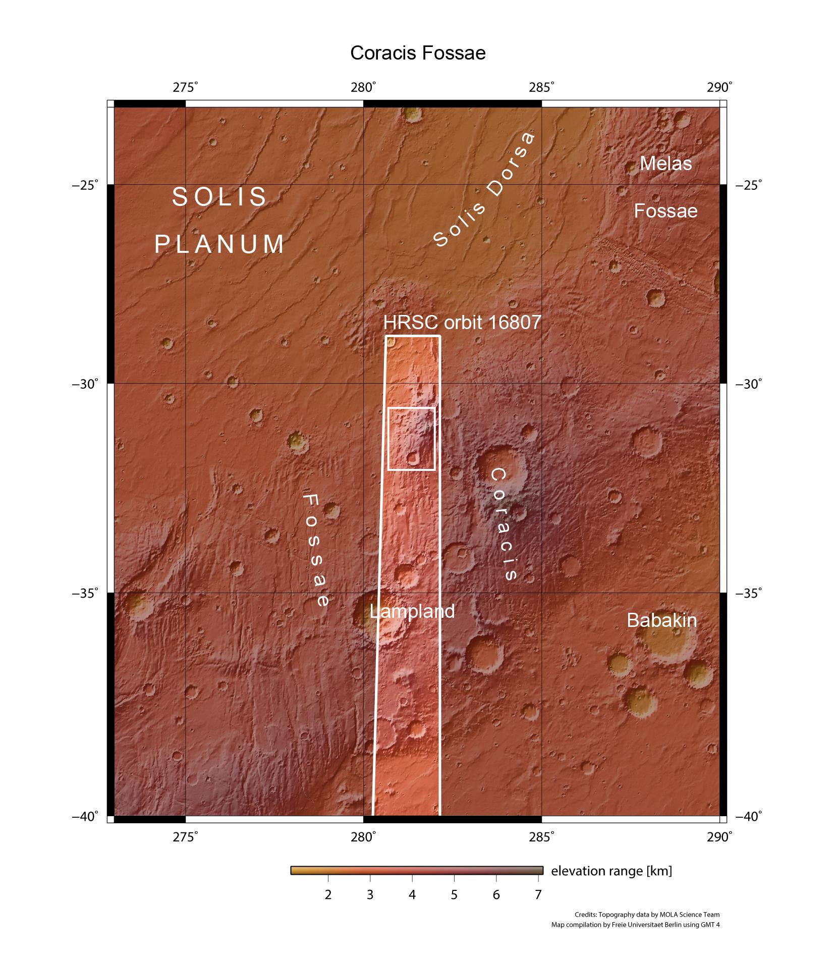
The images were acquired by the HRSC (High Resolution Stereo Camera) on 9 April 2017, during Mars Express orbit 16,807. The image resolution is 13 metres per picture element (pixel). The centre of the image is at about 281 degrees east and 31 degrees south. The colour aerial view was created from the nadir channel oriented perpendicular to the surface of Mars and the colour channels of the HRSC, the perspective angle view was computed from the HRSC stereo channels. The anaglyph image, which conveys a three-dimensional impression of the landscape when viewed with red-blue or red-green glasses, was derived from the nadir channel and one stereo channel. The colour-coded view is based on a digital terrain model (DTM) of the region, from which the topography of the landscape can be derived. The reference unit for the HRSC DTM is a Martian globe. Staff specialising in planetology and remote sensing at the Free University of Berlin produced the views shown here. Systematic processing of the data was carried out at the DLR Institute of Planetary Research in Berlin-Adlersdorf.
The HRSC experiment
The High Resolution Stereo Camera was developed at the German Aerospace Center (Deutsches Zentrum für Luft- und Raumfahrt; DLR) and built in collaboration with partners in industry (EADS Astrium, Lewicki Microelectronic GmbH and Jena-Optronik GmbH). The science team, which is headed by principal investigator (PI) Ralf Jaumann, consists of over 40 co-investigators from 33 institutions and 10 countries. The camera is operated by the DLR Institute of Planetary Research in Berlin-Adlershof. The camera has been delivering images of the Red Planet since 2004.


