Marvellous Mars – from the North Pole to the Southern Highlands
September 19, 2019 | Mars Express mission
Marvellous Mars – from the North Pole to the Southern Highlands
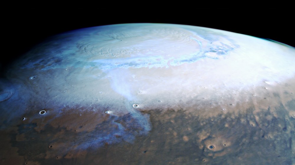
The start of spring at the North Pole on Mars
A rare view of the northern polar region of Mars during spring. The upper half of the image, acquired in June 2019 by the High Resolution Stereo Camera (HRSC), shows the ice cap, which consists of water ice, to striking effect. In winter it is covered by a thin layer of carbon dioxide ice and then also covers large areas of the Vastitas Borealis plain (down to 70 degrees north). A dark, circumpolar ‘channel’ in the middle of the ice coverage marks the boundary between the permanent water ice cap and the layer of carbon dioxide ice. Within the space of a few weeks, this winter layer of carbon dioxide ice sublimates (transitions directly from solid to vapour) once again and the polar cap shrinks back to its summer extent, which extends to approximately 80 degrees north. A thin veil of cloud stretches over the vast dune fields made of dark sand.
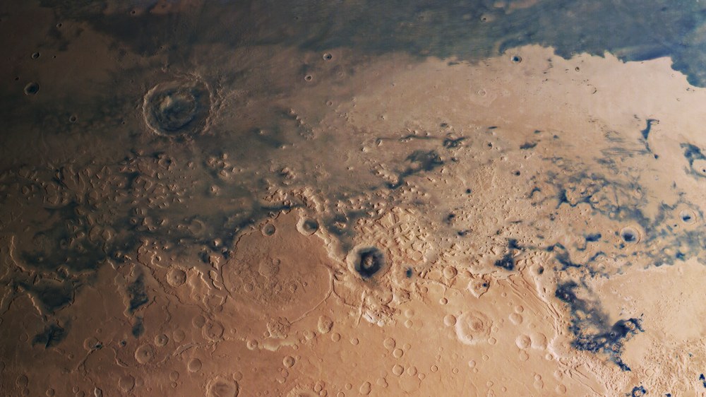
The 'Martian dichotomy' – the transition between the Martian highlands and lowlands
A prominent escarpment marks the border between Mars’ northern lowlands and southern highlands. Dark sands cover large areas of the lowlands. The erosion of this transition zone is advancing from north to south, resulting in isolated inselbergs or buttes in the northern lowland plains, as well as debris fans and areas of landscape that have already been largely eroded. This transition zone from the older highlands to the younger lowlands, referred to as the ‘Martian dichotomy’, ranges in height from 2000 to 4000 metres.
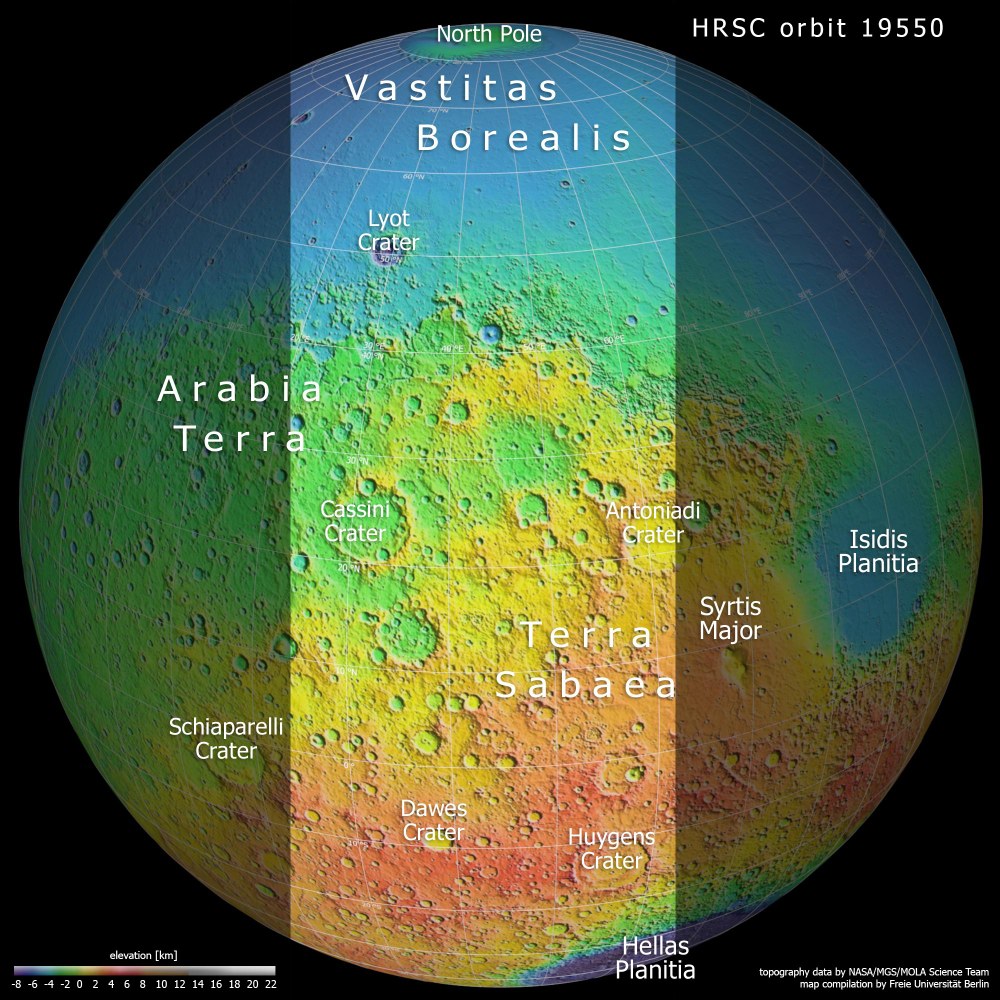
Between 1997 and 2001, NASA’s Mars Global Surveyor spacecraft scanned Earth’s neighbouring planet with a laser altimeter, which recorded high-precision altitude information about the Martian landscape at specific points. This topographical map, based on data from the MOLA (Mars Orbiter Laser Altimeter) experiment, clearly shows the division of Mars into the older southern highlands (coloured green, orange and red) and the younger northern lowlands (blue areas). There is a 2000 to 4000-metre difference in height between these two very different landscapes. The light-coloured section indicates the area imaged by the High Resolution Stereo Camera in June 2019.
In June 2019, the High Resolution Stereo Camera (HRSC) took several global images of Mars.
The HRSC camera experiment on board ESA's Mars Express mission was developed at DLR. It has been operated by the DLR Institute of Planetary Research for more than 16 years.
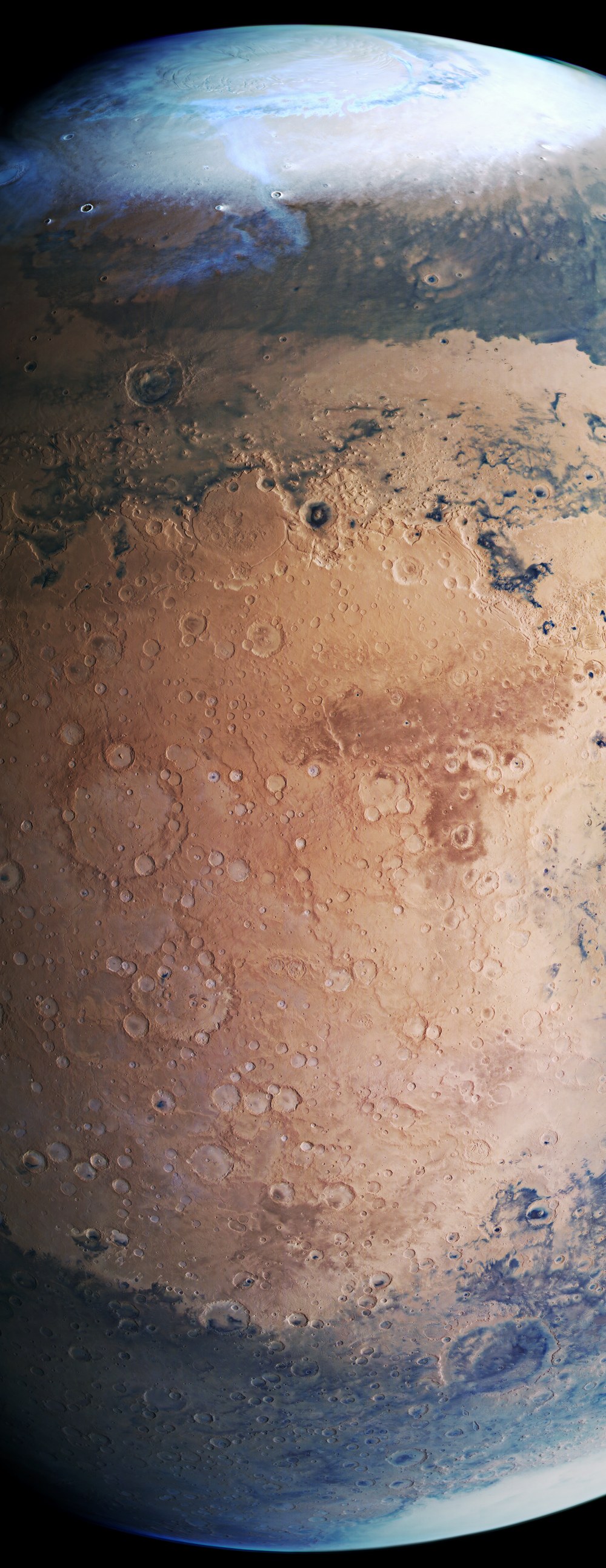
This image shows the north polar ice cap, the border between highlands and lowlands, former river valleys, plains covered by dark sands and the large Hellas Planitia impact basin in the south.
Focus: Space, planetary research
In June 2019 the High Resolution Stereo Camera (HRSC) captured a number of global images of Mars. The view shown in the main image stretches from the North Pole to the heavily cratered highlands around the Martian equator and far into the southern hemisphere. HRSC, which is on board the European Space Agency (ESA) Mars Express spacecraft, was developed by the German Aerospace Center (Deutsches Zentrum für Luft- und Raumfahrt; DLR). It has been operated by the DLR Institute of Planetary Research for more than 16 years. The Institute also processes the data acquired by the camera system. From these data, specialists in planetology and remote sensing at the Freie Universität Berlin have created the images shown here.
The upper part of this striking global view of Mars shows the northern hemisphere and the North Pole ice cap in winter. A thin veil of clouds stretches from there across the adjoining deep valleys, some of which are covered with dark sand. A prominent escarpment is visible in the image. This marks the border between Mars’ northern lowlands and its southern highlands. Dark sands also cover some areas of the crater-strewn highlands. In the extreme south (bottom) of the image, part of the Hellas impact crater is visible, covered by white clouds. The view of the planet is slightly ‘tilted’ towards the south, allowing the North Pole to be seen, but it only extends down to 40 degrees south. The South Pole is therefore not visible. From pole to pole, Mars measures 6752 kilometres; the image shown here covers just under 5000 kilometres of that distance.
Different climate zones and major geographical regions
During winter in the northern hemisphere, the intense cold causes significant quantities of carbon dioxide to precipitate out of the atmosphere above the North Pole; it forms a thin layer above the permanent polar cap, which otherwise consists predominantly of water ice. This ice cover then extends down to approximately 50 degrees north. The water vapour content in the Martian atmosphere, which could potentially freeze to form water ice and fall to the surface as snow or ice, is extremely low. It averages just 0.03 percent and is subject to strong fluctuations. Carbon dioxide, on the other hand, is the major constituent of the Martian atmosphere, accounting for 95 percent of the gases.
The image data were acquired at the beginning of spring in the north; the polar night at the North Pole was over and the polar cap, which had grown during the winter, is gradually beginning to recede. This growth and shrinkage can also be seen at the southern polar cap. The thin white band of cloud (probably composed of water ice crystals) is one of many that appear over the northern hemisphere at this time of year.
Why are the Martian highlands and lowlands so drastically different?
The reddish plains of Arabia Terra and Terra Sabaea in the centre of the image are notable for the presence of many large impact craters, indicating that they are among the oldest regions on Mars. Along their northern border is a striking escarpment, with a difference of several kilometres in height. This separates the flat, barely cratered plains of the northern lowlands from the southern highlands, which have many more craters. This remarkable change in terrain, referred to as the Martian dichotomy, marks a fundamental topographical and regional division on Mars. This is reflected, most importantly, in the different crust thicknesses, but also extends to the magnetic properties of the crust and its gravitational field. There is still a certain amount of scientific debate over how this crust dichotomy came about. It could have originated from ‘endogenous’ forces in the Martian interior and thus been caused by mantle convection or tectonics. If ‘exogenous’ (external) forces were responsible, this effect could perhaps be traced back to one or more major asteroid impacts.
The intensely rugged landscape at the dichotomous boundary has been severely eroded over millions of years, and is now characterised by numerous tectonic faults, mesas and river valleys. Observations have revealed that fluvial, aeolian and, in particular, glacial processes have altered the transition zone. Analysis of the image data suggests that there may have been several episodes of glacial activity during the evolution of Mars.
How winds have shaped the surface of Mars
Geological processes (volcanism, tectonics, water and ice activity) have come to a standstill on Mars. Today, changes that can be observed on the surface are primarily caused by the wind-induced displacement of dark sands. While these sands, which are of volcanic origin, form vast dune fields in depressions such as impact craters, they are also often deposited over other large areas, which causes parts of the planetary surface to have a dark appearance. The displacement of dunes can be observed over a timeframe of one to two years using high-resolution image data.
In contrast, shifts in the wide-area layers of sand take much longer. When the Italian astronomer Giovanni Schiaparelli (1835–1910) first mapped Mars in 1877, during a period when observation conditions were particularly favourable, changes in the distribution of light and dark surfaces on Mars could be monitored over a longer period. It was then believed that the movement of the dark areas were caused by seasonal changes in vegetation cover. This was one source of the belief that there was life on Mars.
Image processing The images were acquired by the HRSC (High Resolution Stereo Camera) on 17 June 2019 during Mars Express Orbit 19550. The ground resolution in the centre of the image is approximately one kilometre per pixel and the image is centred at 44 degrees East and 26 degrees North. The colour image was created using data from the nadir channel, the field of view which is aligned perpendicular to the surface of Mars, and the colour channels of the HRSC. The context maps are based on data of the Viking mission and of the Mars Orbiter Laser Altimeter (MOLA) experiment on board the Mars Global Surveyor (MGS) mission of NASA.
The HRSC experiment on Mars Express The High Resolution Stereo Camera was developed by the German Aerospace Center (Deutsches Zentrum für Luft- und Raumfahrt; DLR) and built in collaboration with partners in industry (EADS Astrium, Lewicki Microelectronic GmbH and Jena-Optronik GmbH). The science team, which is headed by Principal Investigator (PI) Ralf Jaumann, consists of 52 co-investigators from 34 institutions in 11 countries. The camera is operated by the DLR Institute of Planetary Research in Berlin-Adlershof.
