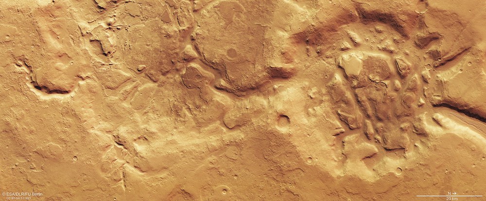
Colour plan view of a part of the Nilosyrtis Mensae region
This image, acquired by the High Resolution Stereo Camera (HRSC) on 29 September 2019, shows part of the Nilosyrtis Mensae region. Water, wind and ice have changed the landscape dramatically, leaving behind soft-edged terrain, rounded mountain tops and highly eroded craters and river valleys.
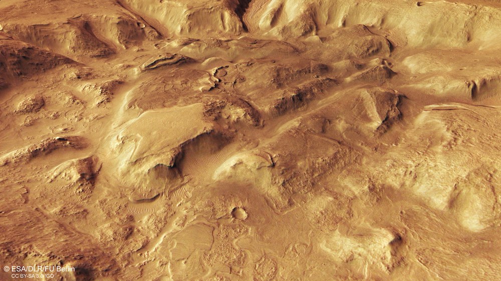
Oblique perspective view of a heavily weathered crater in Nilosyrtis Mensae
Erosion by water and ice have left rounded mountain tops and mesas in Nilosyrtis Mensae. This former impact crater became shallower and shallower over time due to fluvial and glacial erosion (erosion by water and ice) and the deposition of eroded material and windblown sediment. The crater relief has now all but disappeared.
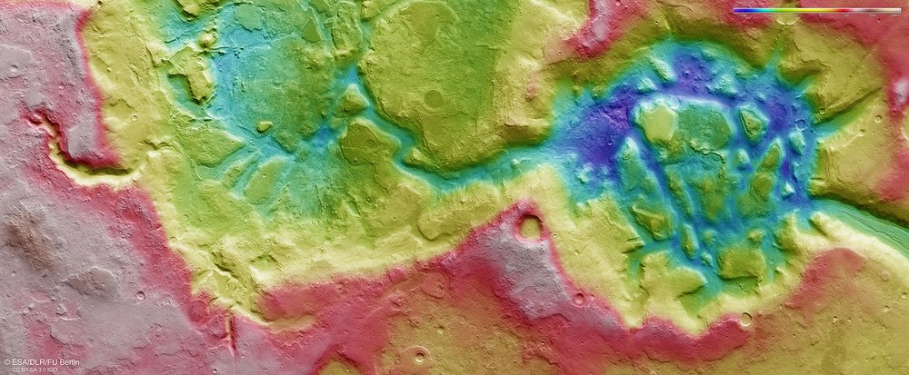
Topographic map of the rugged region of Nilosyrtis Mensae
Using the image strips that the High Resolution Stereo Camera (HRSC) on Mars Express has recorded from various angles, researchers from DLR and Freie Universität Berlin compute digital terrain models of the surface of Mars. Each image point contains altitude information. The colour coding of the digital terrain model (legend in the top right-hand corner) provides information about the altitude differences in the Nilosyrtis Mensae region.
Images acquired by the HRSC Mars camera show a section of the Nilosyrtis Mensae region, which has been significantly altered by water, wind and ice.
This 'fretted terrain' is traversed by numerous valleys; this indicates the episodic occurrence of water.
Rock glaciers have also left their traces here as they moved down the valleys.
Space, planetary research
The northern and southern hemispheres of Mars differ fundamentally in terms of surface topography, age and morphology. In the north is an extensive lowland region that is relatively flat and much younger than the heavily cratered southern highlands. The transition zone between the two is characterised by a steep escarpment with an altitude difference of several kilometres. This region is referred to as the Martian dichotomy boundary.
The Nilosyrtis Mensae region is referred to as 'fretted terrain' and is characteristic of the transition zone between the highlands and lowlands on Mars. The numerous labyrinthine valleys that can be seen in these images are typical for such areas.
These images, acquired by the High Resolution Stereo Camera (HRSC) on board ESA's Mars Express spacecraft, show a landscape that has been heavily eroded by water, wind and ice. This is demonstrated by the many deep valleys and flattened crater rims. HRSC has been mapping Earth's neighbouring planet since 2004; it was developed and is operated by the German Aerospace Center (Deutsches Zentrum für Luft- und Raumfahrt; DLR).
Rock glaciers once flowed down the valleys
The valley floors, especially in the northern parts of images 1, 4 and 5, show linear structures that follow the course of the valley. These 'lineated valley fills' suggest that ice-bearing material flowed slowly down the valley slopes and met in the centres of the valleys. Such debris-covered glaciers are similar to the rock glaciers that are found on Earth. Rock glaciers consist of ice mixed with debris and boulders. On Earth, they are mainly found in high-altitude permafrost regions or at polar latitudes.
The glacier-like deposits are possibly the remains of a receding ice sheet that covered the region during past ice ages. Earlier climate conditions on Mars apparently led to the deposition of larger amounts of snow and ice on the plateaus and in the valleys.
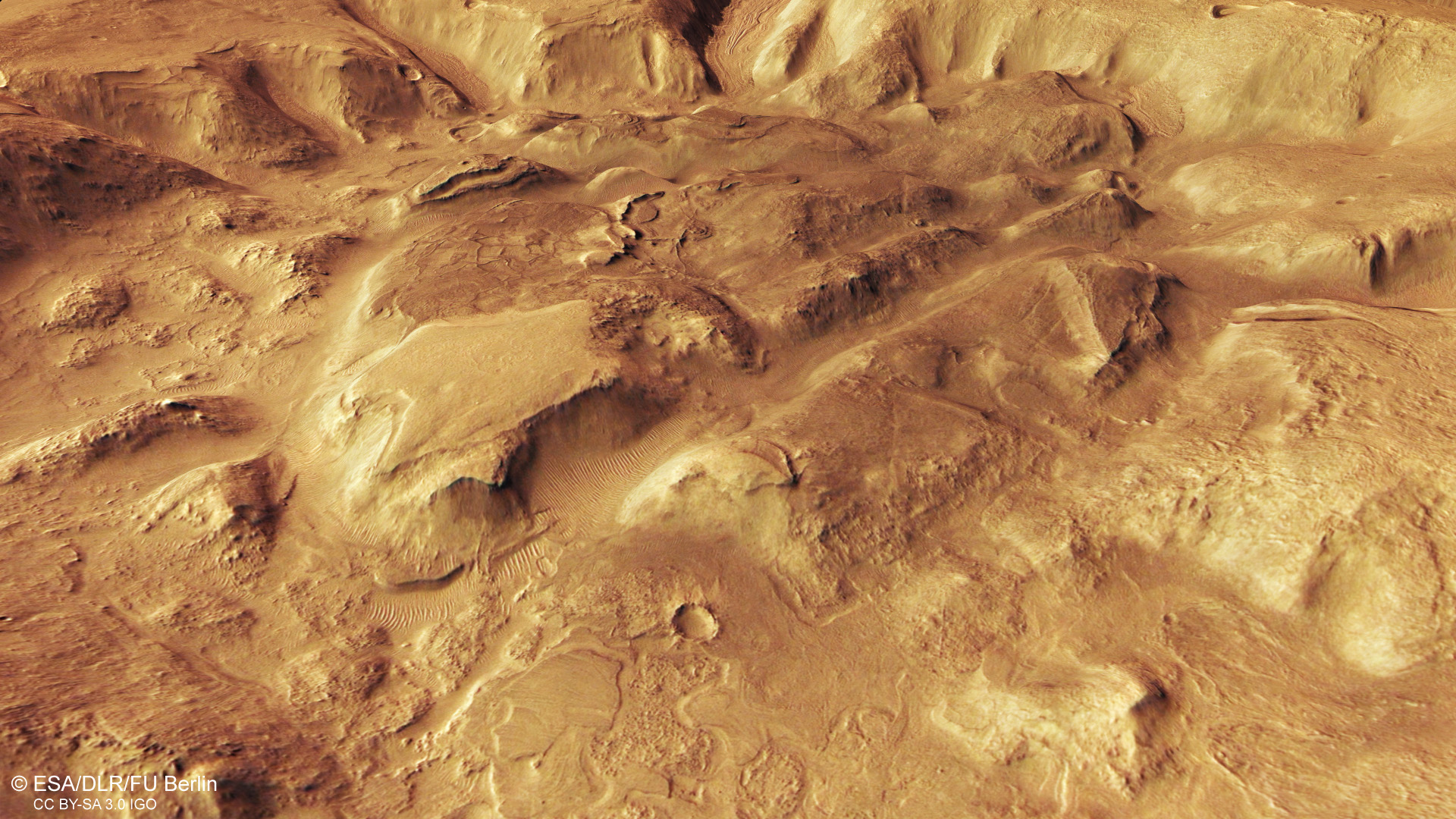
Erosion by water and ice has left rounded mountaintops and mesas in Nilosyrtis Mensae. Many of the terrain forms shown in the image have a soft-edged appearance, which is attributed to extensive overprinting by ice. The former impact crater (to the right in images 1, 4 and 5) became shallower and shallower over time due to the erosion of its rim and the deposition of eroded material and windblown sediment. The crater relief has now all but disappeared. The crater filling was in turn heavily eroded and carved up, giving it its present rugged appearance.
Water, wind and ice have changed the landscape dramatically
In contrast to the typical soft-edged terrain of this region, the south-western parts (top left) of images 1, 4 and 5 show rather sharp-edged structures. A sharp-edged linear structure several kilometres long, running almost north-south, is probably what is referred to as a dike. This is the name given to a vertical cleft in the surrounding rock into which magmatic rock has penetrated, and which now protrudes at the surface due to its greater resistance to erosion. To the west of it (above, in the image) is a tangle of intersecting structures, which also have sharp-edged ridges. These are most likely solidified infillings of cracks in the rock. Water once seeped through this rock, washing out various minerals, which then 'fell out' into the cracks and solidified.
The former, dried-up river valley in the south of the image (left) was eroded by constantly leaking groundwater, which can be seen from the broad, semi-circular valley heads. At wider points on the valley floor further downstream (in the centre/left of the image), smaller river courses have cut into the lineated valley fill. This points to repeated, episodic fluvial activity in this region.
Systematic processing of the data acquired by HRSC took place at the DLR Institute of Planetary Research. From these data, staff in the Department of Planetary Sciences and Remote Sensing at the Freie Universität Berlin created the image products shown here. The image data were acquired by HRSC on 29 September 2019 during Mars Express orbit 19,908. The ground resolution is approximately 15 metres per pixel and the images are centred at approximately 69 degrees east and 31 degrees north. The colour image was created using data from the nadir channel, the field of view which is aligned perpendicular to the surface of Mars, and the colour channels of HRSC. The oblique perspective view was generated from a digital terrain model and data acquired by the nadir and colour channels of HRSC. The anaglyph, which provides a three-dimensional view of the landscape when viewed using red-green or red-blue glasses, was derived from data acquired by the nadir channel and the stereo channels. The colour-coded topographic view is based on a Digital Terrain Model (DTM) of the region, from which the topography of the landscape can be derived. The reference body for the HRSC-DTM is a Mars equipotential surface (Areoid).
The HRSC experiment on Mars Express
The High Resolution Stereo Camera (HRSC) was developed by the German Aerospace Center (Deutsches Zentrum für Luft- und Raumfahrt; DLR) and built in collaboration with partners in industry (EADS Astrium, Lewicki Microelectronic GmbH and Jena-Optronik GmbH). The science team, which is headed by Principal Investigator (PI) Ralf Jaumann, consists of 50 co-investigators from 35 institutions in 11 countries. The camera is operated by the DLR Institute of Planetary Research in Berlin-Adlershof; it has been delivering high-resolution images of the Red Planet since 2004.
