Glaciers as landscape sculptors – the mesas of Deuteronilus Mensae
November 21, 2019 | Mars Express mission
Glaciers as landscape sculptors – the mesas of Deuteronilus Mensae
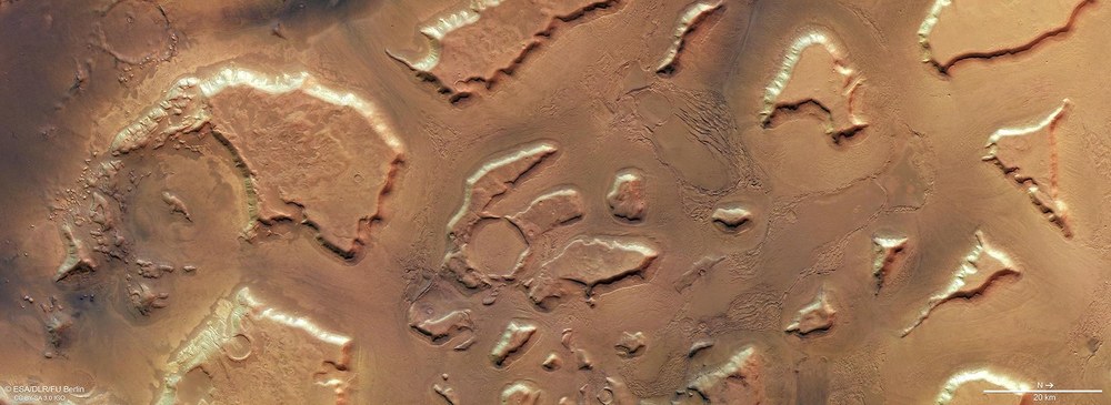
View of the northern part of the Deuteronilus Mensae region
Individual mesas up to 30 kilometres across rise as ‘outliers’ from the plain in the transition zone from the Martian highlands further south (left) to the northern lowlands (right). Deuteronilus Mensae is a very typical region for this ‘dichotomy boundary’ on Mars. The 2000-metre-tall mountains show that the Mars highlands previously extended further north but were largely flattened by erosive processes. Glacial ice and flowing water carried highland debris northwards into the lowlands. Traces of the glaciations can be seen particularly well between the mesas, in the form of various linear structures.
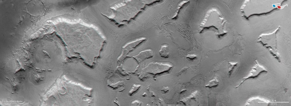
Mesas and heavily eroded craters in Deuteronilus Mensae
The fragmentation and erosion of the old highland area left behind different large mesas. Their plateau-like surfaces represent the remnants of a land surface that once extended much further north. There have probably been several phases of glaciation. Some impact craters in the region, like the one on the left-hand side of this image, have heavily eroded rims and have been completely filled by debris deposited in them. This crater is now barely recognisable as a circular structure.
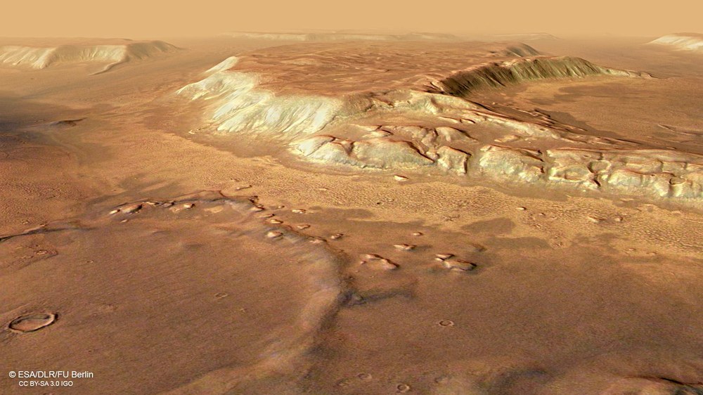
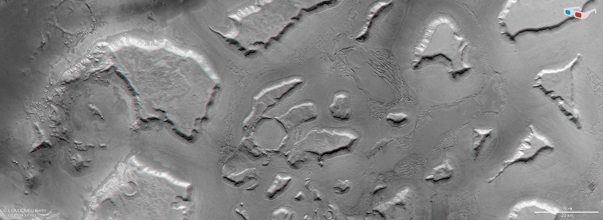
3D view of the northern part of Deuteronilus Mensae
Anaglyph images can be generated from data acquired by the nadir channel of HRSC, which is oriented vertically onto the surface, and one of the four oblique-view stereo channels. When viewed with red-blue or red-green glasses, these images give a realistic, three-dimensional view of the landscape. North is to the right. The mesas, protruding strikingly from the surrounding plain, have been preserved as ‘outliers’ in the northern lowlands, following the erosion of the southern highlands. They are approximately 2000 metres high. The image resolution of 13 metres per pixel makes it possible to observe structures on the deposited sediments between the mesas. These provide information about glacial erosion processes.
As on Earth, glaciers and ice ages have shaped the landscape on Mars. The Deuteronilus Mensae region has evidence of glacier movements, such as mesas.
The lower terrain in the north and the regions between the mesas are evenly covered by deposits resembling rock glaciers found on Earth.
Measurements have shown that most of the glacier-like structures in Deuteronilus Mensae still contain a high proportion of pure water ice today (80 to 90 percent).
Focus: Space, planetary research
During ice ages on Earth, the retreating ice sheets greatly altered the landscape of the continents. Over the past two-and-a-half million years, Central Europe alone has experienced five massive glaciations. Ice from the Arctic spread as far south as Central Europe while at the same time, the kilometre-thick glaciers of the Alps pushed their way north as far as today's Danube. When the glaciers retreated during 'warm' (interglacial) periods, they typically left behind landscapes with moraines or ice age lakes. The U-shaped valleys of the Alps are evidence of this, as are the glacial erratics – rocks and stones from Scandinavia or the Alps that were carried for hundreds of kilometres on the glacial conveyor belts. Similarly, glaciers and ice ages have also shaped the Martian landscape. A particularly impressive example of this is the Deuteronilus Mensae region on the border between the southern highlands and the northern lowlands. This region is shown in these images, which were created using data acquired by the High Resolution Stereo Camera (HRSC) operated by the German Aerospace Center (Deutsches Zentrum für Luft- und Raumfahrt; DLR) on board ESA's Mars Express spacecraft.
The Deuteronilus Mensae region is approximately the size of Germany. It forms a striking area of the Martian dichotomy boundary, where the planetary surface transitions from the southern highlands to the lowlands of the northern hemisphere, 1000 to 2000 metres below. This boundary is characterised by numerous mesas, remnants of the erosion that reached from north to south.
Rocks carved from between the mountains were carried north
Although the valleys between these mesas were created in part by the erosive effect of flowing water, there are also numerous signs that glaciers also significantly shaped the landscape. As on Earth, glacial ice – moving very slowly and plastically under its own weight – produces a strong erosive force. The material sheared off at the bottom of the glaciers and the rocks falling onto the ice from the steep slopes at the sides of the glaciers were carried away by the glacier tongues as they advanced slowly northwards; the rocky material was also crushed by intense friction.
The fragmentation and erosion of the old highland area left behind a number of large mesas. Their plateau-like surfaces represent the remains of a land surface that once extended much further north.
The landforms indicate that there must have been several phases of glaciation. Many impact craters in the region have heavily eroded rims and have been almost completely filled by material that was carried to them and then deposited by glaciers. In some places they can still be seen as circular structures with flat bases, while in other craters only the central peak protrudes partially from the sediment (Image detail 2).
Mars ice ages in geologically recent times
The lower lying terrain in the north and the regions between the mesas are evenly covered by sediments whose surface texture suggests a slow, viscous downward movement of a mixture of debris and ice. The concentric lobate debris aprons (Image details 3 and 4) around the plateaus resemble rock glaciers or glaciers completely covered with debris, like those in cold climatic regions on Earth, such as Antarctica. The patterns formed by rubble and debris on glaciers moving down into valleys reflect the different flow velocities of the underlying viscous ice.
It is very likely that there is still ice under this carpet of rock, even if it is not visible today. Surface ice on Mars is only found in the northern and southern polar regions in the form of ice caps, and as frost on dune ridges or crater rims, where temperatures are extremely low – it is often mixed with carbon dioxide ice. In mid-latitude regions such as Deuteronilus Mensae, summer temperatures rise above zero degrees Celsius and surface water ice would normally sublimate immediately, given the low atmospheric pressure on Mars. However, if the ice is blanketed by rocky debris, it is likely that sublimation can be prevented for thousands of year.
When interpreting the structures in Deuteronilus Mensae, some scientists assume that glaciers existed here in geologically recent times – hundreds of thousands or perhaps even only 10,000 years ago – and that there could have even been ice ages similar to those on Earth. Since the obliquity of the rotational axis of Mars is thought to have changed substantially on timescales of hundreds of thousands or millions of years, different areas of the planetary surface may have been directed towards or away from the Sun. This implies that large-scale icing could also have occurred at these mid-latitudes.
This assumption is confirmed by the analysis of data from the Shallow Radar (SHARAD) instrument on board NASA's Mars Reconnaissance Orbiter, which can detect the presence of liquid or frozen water up to several hundred metres below the surface. Its measurements show that most glacier-like structures in Deuteronilus Mensae still contain a high proportion of pure water ice today (80 to 90 percent). They could thus be the remains of a supra-regional ice sheet that once covered the plateaus and adjacent plains of the region. Increasing sublimation of ice as the Martian climate changed could then have led to degradation of this extensive ice sheet, exposing the slopes of the plateaus and further eroding them. The fretted texture (Image details 4 and 8) of the lower lying areas, which can be seen to the right of centre in image 1, can be explained by downhill creep of the ice debris mixture and the resulting fracture and compression patterns.
Image processing
Systematic processing of the data acquired by HRSC took place at the DLR Institute of Planetary Research. From these data, staff in the Department of Planetary Sciences and Remote Sensing at the Freie Universität Berlin created the image products shown here. The image data were acquired by HRSC on 25 February 2018 during Mars Express orbit 17,913. The image resolution is approximately 13 metres per pixel. The centre of the images is located at approximately 25.5 degrees east and 44 degrees north. The colour image was created using data from the nadir channel, the field of view of which is aligned perpendicular to the surface of Mars, and the colour channels of HRSC. The colour-coded topographic view is based on a Digital Terrain Model (DTM) of the region, from which the topography of the landscape can be derived. The reference body for the HRSC-DTM is a Mars equipotential surface (Areoid). The oblique perspective view was generated from the DTM and data from the nadir and colour channels of HRSC. The anaglyph, which provides a three-dimensional view of the landscape when viewed using red-green or red-blue glasses, was derived from data acquired by the nadir channel and the stereo channels.
The High Resolution Stereo Camera was developed by the German Aerospace Center (Deutsches Zentrum für Luft- und Raumfahrt; DLR) and built in collaboration with partners in industry (EADS Astrium, Lewicki Microelectronic GmbH and Jena-Optronik GmbH). The science team, which is headed by Principal Investigator (PI) Ralf Jaumann, consists of 50 co-investigators from 35 institutions in 11 countries. The camera is operated by the DLR Institute of Planetary Research in Berlin-Adlershof; it has been delivering high-resolution images of the Red Planet since 2004.
