Digitalisation in agriculture – field testing DLR technologies
March 30, 2020
Digitalisation in agriculture – field testing DLR technologies
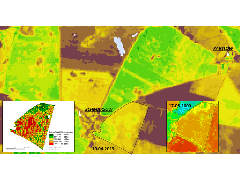
Winter wheat yield map
Even with a pixel resolution of 30 metres by 30 metres, a differentiation within the field can be demonstrated, which may indicate different management requirements. The in-field differences, which can be detected by satellite remote sensing, may be reflected in the yield data. The yield map of winter wheat from the year 2000 (left, with permission of Daberkower Landhof AG, created by Edgar Zabel) can be visually correlated with the in-field differentiation visible in the Landsat 5 TM scene from 17 May 2000. In the background, a Landsat 8 OLI scene from 19 April 2019 can be seen. It shows a similar appearance. Both scenes show the Normalised Difference Vegetation Index (NDVI) as a simple indicator of biomass activity at the time of acquisition.
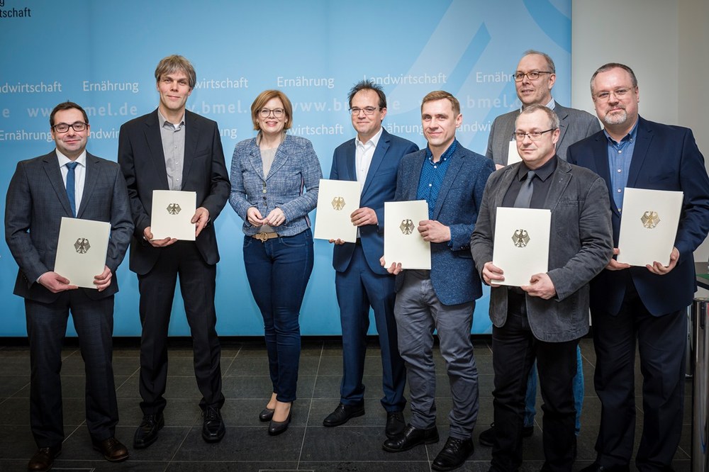
German Federal Minister of Food and Agriculture Julia Klöckner with representatives of the AgriSens project at the formal handing over of the funding confirmation in Berlin
On 9 March 2020, the German Federal Minister of Food and Agriculture, Julia Klöckner, handed over the funding confirmation for the ‘AgriSens DEMMIN 4.0’ project.
Image: 2/2, Credit:
Bundesministerium für Ernährung und Landwirtschaft / Felix Zahn, photothek.net
Remote sensing data can be useful in agriculture for increasing productivity while protecting the environment and biodiversity. In the 'AgriSens DEMMIN 4.0 – Remote Sensing Technologies for Digitalisation in Crop Production' project, the German Aerospace Center (Deutsches Zentrum für Luft- und Raumfahrt; DLR) is assessing remote sensing technologies suitable for digitalisation applications in the agriculture sector. This is being carried out using regional field testing at an experimental site in Mecklenburg-Western Pomerania.
"The focus is primarily on testing technologies for applications that can assist farmers to estimate crop yield, identify areas with lower yields, and assess soil moisture content," explains Erik Borg of the German Remote Sensing Data Center in Neustrelitz. Geodata collected by remote sensing instruments carried by satellites or drones are used for this purpose.
The test field is located about 220 kilometres north of Berlin, near the city of Demmin, and is well suited for this project because it is used intensively for agriculture. "The 'DEMMIN' test field has existed for 20 years and was established especially for testing remote sensing methodologies. In particular, the varied landscape found here makes it possible for us to develop and test a wide range of remote sensing applications in a relatively limited area under different constraints at reasonable cost," Borg further explains. "Already, the pixel resolution of the sensors poses a challenge for agricultural applications. Digitalisation in agriculture should help reduce the cost of obtaining data and information, as well as improve the consultation services based on them."
DLR provides the scientific foundation
In the 'AgriSens DEMMIN 4.0' project, researchers from a number of DLR institutes are combining their expertise. These include the German Remote Sensing Data Center's departments 'Land Surface Dynamics' and 'National Ground Segment', and the Institute of Data Science, founded in 2017, with its 'Citizen Science' department. The German Remote Sensing Data Center supplies the satellite data that form the basis for crop monitoring. “For the DEMMIN test area, our Earth observation time series and information layers can be compared with the in-situ measurements collected by our project partners, which makes it possible to provide high-quality information," explains Sarah Asam of the Land Surface Dynamics Department. Together with scientists from DLR’s Citizen Science Department and Friedrich Schiller University (FSU) in Jena, citizen science strategies are developed that involve agricultural stakeholders in the data collection. Sina Truckenbrodt of FSU Jena explains: "Farmers have very detailed local knowledge and extensive experience in managing their arable land. In light of the increasing lack of people with expertise, it is crucial to preserve and pass on this knowledge. So, together with farmers, we want to develop digital maps and recommendations for action in order to ensure easy access to existing knowledge." For example, local knowledge for mapping low-yield acreage is to be collected and combined with information from Earth observation satellite time series and made available to farmers in the form of information products. "By combining expertise from the three complementary research fields of remote sensing, data science and citizen science, 'AgriSens DEMMIN 4.0' makes it possible to develop and test innovative agricultural technologies. Because of long and trusted collaboration with the Remote Sensing Data Center and FSU Jena, DEMMIN offers particularly good conditions for actively involving farmers in timely recording strategies," says Friederike Klan of the DLR Institute of Data Science in Jena.
Making low-threshold offers for the agriculture sector
The project goal is to provide farmers with data sets they can consult to obtain information important for their work. Such information serves as a basis for decisions relating to fertilising, sowing and soil cultivation. "At present, the obstacles to using these data are unfortunately much too high for many farmers. This applies, above all, to accessing the data and using it in a multitude of software solutions and confusing market offerings. We intend to offer low-threshold solutions," says Daniel Spengler, project coordinator, spokesman for the test field, and scientist at the German Research Centre for Geosciences (GeoForschungsZentrum; GFZ) in Potsdam.
Science and agriculture in alliance
The AgriSens DEMMIN 4.0 research association is composed of GFZ Potsdam, DLR, the Julius Kühn Institute Braunschweig, the Deutscher Wetterdienst (Germany's national meteorological service), Martin Luther University Halle-Wittenberg, FSU Jena, Julius Maximilian University Würzburg, and Neubrandenburg University of Applied Sciences. The participants from the agricultural sector include regional agricultural enterprises in the Demmin area of Mecklenburg-Western Pomerania and partner companies of the participating research institutes throughout Germany. Interested agricultural stakeholders still have the opportunity to join the project.
On 9 March 2020, the German Federal Minister of Food and Agriculture, Julia Klöckner, presented the funding confirmation for the AgriSens DEMMIN 4.0 project. DLR's contribution is supported with a project grant of 1.04 million euro (Grant identification number 28DE114C18).
Contact
Melanie-Konstanze Wiese
Corporate Communications Berlin, Neustrelitz, Dresden, Jena and Cottbus/Zittau

