DLRmagazine 144 – Footprints of humankind on the Blue Planet
1.2 MB | PDF

Many people in Africa are at risk from natural hazards – particularly in towns and cities that are growing rapidly and in an unplanned way. Here, the consequences of floods, storms or earthquakes can have a particularly devastating impact. But where are cities growing rapidly right now? Have new settlements been built in vulnerable areas? And how many people are at risk in these cases? Until now, there have often been insufficient answers to these questions. This is why the German Aerospace Center (Deutsches Zentrum für Luft- und Raumfahrt; DLR) and the World Bank have worked together to evaluate Earth observation images from the entire African continent and combine them with other data sources. The aim of the joint project was to provide planners and decision makers on the ground with up-to-date and reliable figures on the situation and development in the cities, thus making it possible to identify critical changes at an early stage.
Adequate and up-to-date infrastructure and service delivery is essential for the future of Africa's cities. This applies, for example, to Kumasi in Ghana with 3.3 million inhabitants, or Matola in Mozambique with 1.7 million inhabitants. There was hardly any data available despite their rapid growth. "The lack of up-to-date and spatially detailed information has been the biggest problem in assessing the population's exposure to natural hazards. Particularly in less developed countries, regular mapping based on open and free satellite data therefore has a central role to play in adapting to extreme events. The new data will be made available to experts and the general public alike," explains Anke Pagels-Kerp, Divisional Board Member for Space at DLR.
As part of the Satellite-based Monitoring Service of Urbanization in Africa project, the DLR team used high-performance computers to process satellite data with machine learning methods. The large volumes of data come primarily from the European Sentinel satellites and the US Landsat programme. These Earth observation missions collect Petabyte of high-resolution, free imagery over Africa every day. DLR has developed methods to extract the necessary information from hundreds of thousands of satellite images. "With these results, we now understand the dynamics of settlement development across Africa over the last three decades. In combination with building information, we were even able to provide more accurate estimations of the population distribution for individual buildings," says Thomas Esch from the German Remote Sensing Data Center (DFD) in Oberpfaffenhofen.
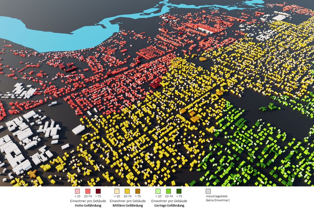
The DLR material includes detailed maps of all cities and settlements. Among other things, they show the distribution of built-up areas and open spaces. In addition, the annual expansion of all settlement areas since 1985 is displayed. A 3D settlement structure serves as the basis for calculating population density. Studies on growth patterns and urban sprawl are also available for more than 100 African cities. In regions such as Maradi (Niger), for example, numerous buildings have sprung up around the traditional city centre within a year. Such often unplanned changes can be tracked through satellite data and the maps updated on a monthly basis. "Based on this information, cities are better able to characterise the exposure today of vulnerable communities as well as assess their current disaster risk and project future trends more accurately. These data can support improved municipal service delivery, outline future infrastructure needs and support an evidence-based approach to risk mitigation, for example by adapting their infrastructure to new conditions in sufficient time", explains Niels Holm-Nielsen, lead of the Resilience and Disaster Risk Management, Social, Urban, Rural and Resilience at the World Bank.
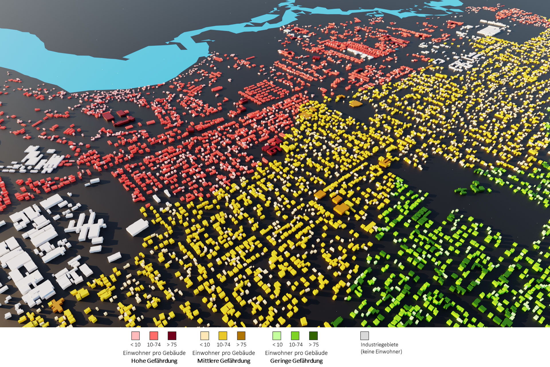
"In the sophisticated analyses, we benefit from our experience in creating user-oriented information products. DLR's treasure trove of data is one-of-a-kind," says Thomas Esch. All current products of the World Settlement Footprint (WSF) have been incorporated into the analyses. These include the WSF 2015, WSF 2019, WSF Evolution, WSF Imperviousness, WSF 3D and WSF population. These products of the WSF mapping programme have been further developed by DLR and used by international institutions such as the World Bank or the United Nations for many years. The data characterise the settlement structure, show developments, map the height, density and volume of buildings, and describe the population distribution.
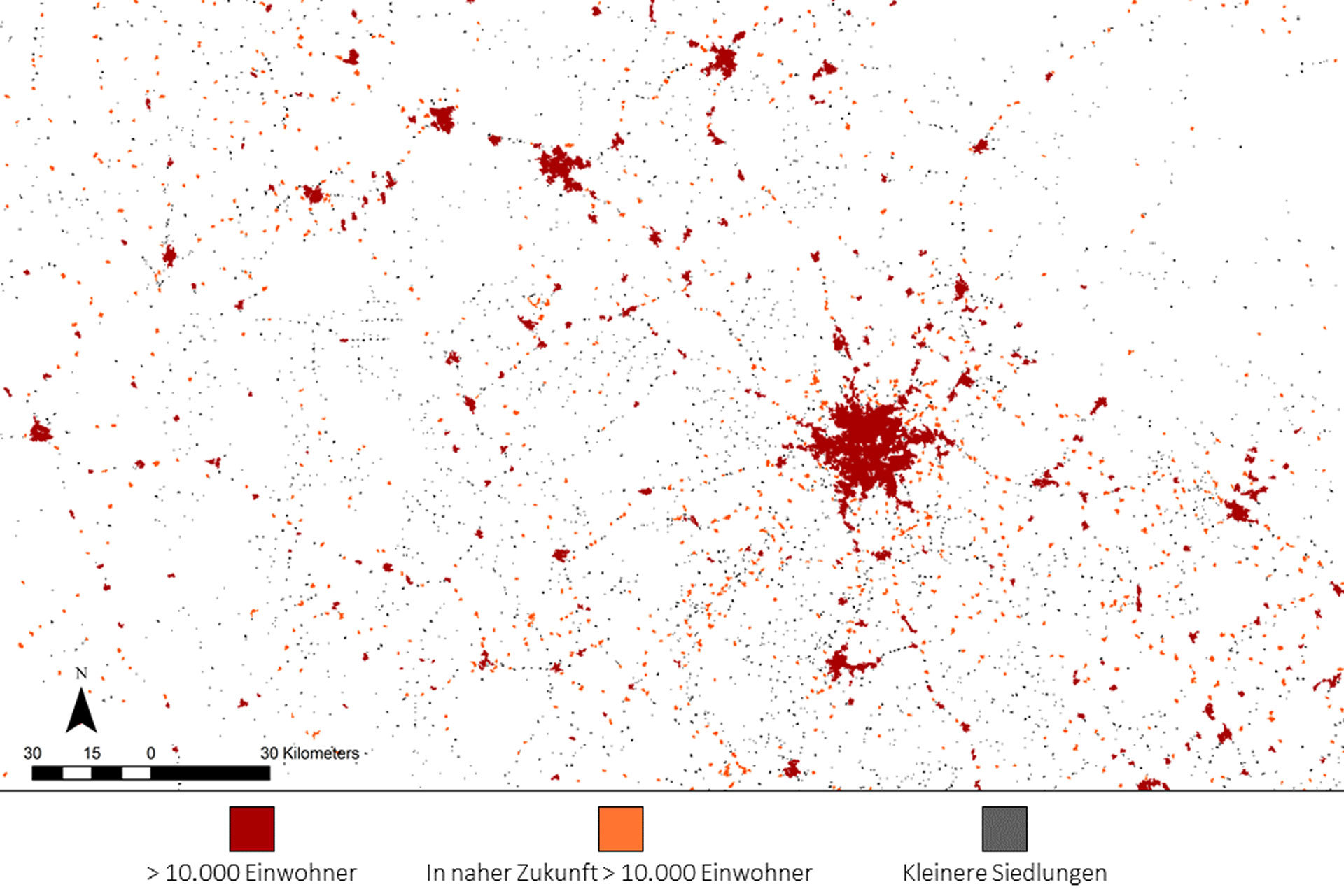
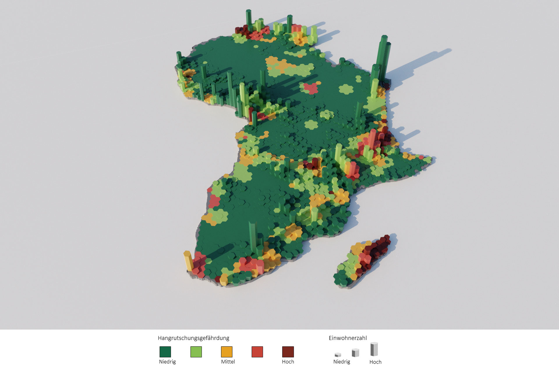
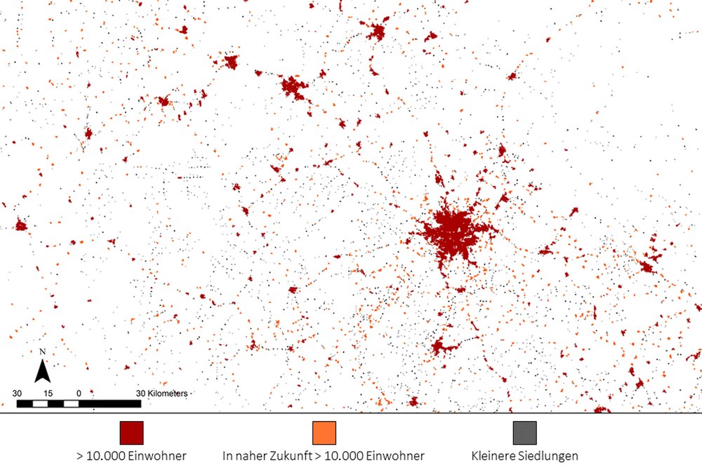
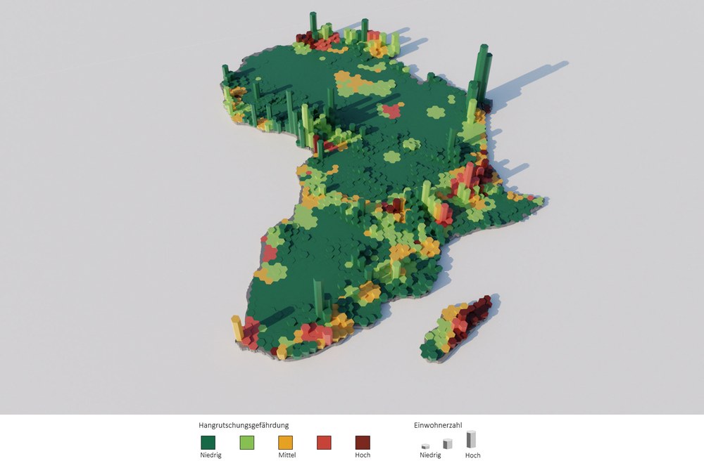
DLR has recorded the main characteristics of all settlements in Africa with more than 10,000 inhabitants in a database. This register currently includes 9472 cities as well as 10,159 additional settlements that will exceed 10,000 inhabitants in the near future. By combining various data sources, the DLR researchers can even estimate the number of inhabitants for each individual building. In addition, the database contains area-wide information on the intensity of natural hazards such as floods, landslides and earthquakes on the African continent.
To ensure that the calculated data is correct, the World Bank has issued small-scale contracts to residents of various African cities. "Reliable comparisons are important to successfully train algorithms and objectively validate the resulting geoinformation," says Esch. The participants were able to contribute their knowledge of the environment and were made more aware of the situation in their cities. At the same time, working in the project helped secure a monthly income during the COVID-19 pandemic.
About the project:
The Satellite-based Monitoring Service of Urbanization in Africa project is funded through the EU ACP-EU Natural Disaster Risk Reduction Program. It is coordinated by the Global Facility for Disaster Reduction and Recovery (GFDRR) at the World Bank. The World Settlement Footprint (WSF) layers utilised in this project were developed by the German Aerospace Center (DLR), in close cooperation with the European Space Agency (ESA) and the Google Earth Engine team. The building perimeter datasets are provided by Ecopia AI / Maxar Technologies and Google. The Think-Hazard! initiative contributes the information on the intensity of natural hazards.
The DLR project team was supported by the DFD research group, which specialises in the development of early warning and crisis information systems. The DLR researchers jointly developed a web-based application through which World Bank staff and planners in the field can access all data, indicators and analyses.
The World Bank and DLR will continue their cooperation. The WSF 2015, WSF 2019 and WSF Evolution products are available for download free of charge through the EOC Geoservice. The WSF data have already been successfully used by the World Bank for other issues with high social relevance.