Vertical plan view of a part of ‘Holden Basin’ with chaotic terrain
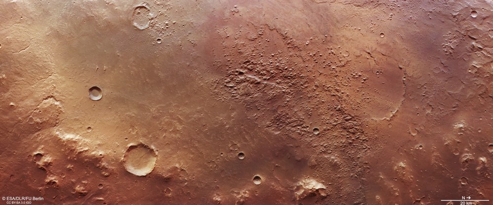
This depression, about 270 kilometres across, is thought to be the remnant of a very old impact basin on Mars that once contained considerable amounts of ground ice. Sudden melting of the ice and drainage of the water created cavities in the subsurface, which then collapsed, creating the chaotically fractured landscapes in the centre of the image. At the southwestern edge of this basin is the Holden impact crater (not pictured here), which is why this depression is sometimes unofficially called ‘Holden Basin’. North is to the right in the image.
Perspective view to the south of the chaotic terrain
This 'chaotic terrain' is located at the lowest point of a large depression up to 2000 metres deep and measures approximately 40 by 80 kilometres. Such fractured landscapes occur when ice reservoirs in the subsurface melt, due to volcanically induced heat, for example, and considerable amounts of water are suddenly released and flow away. This causes the surface above the newly formed cavities to collapse and the landscape to fall in on itself. The exact trigger for the formation of the chaotic terrain here at this location is still unclear today.
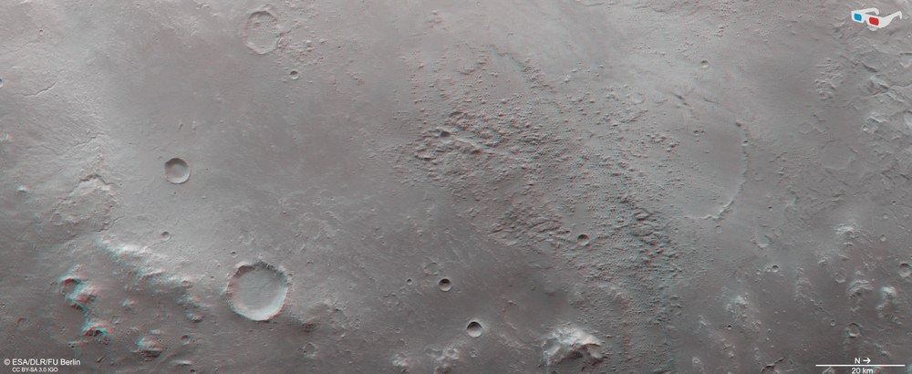
Anaglyph images can be generated using data acquired by the nadir channel (oriented perpendicularly towards the surface of Mars) of the DLR-operated HRSC camera system on ESA's Mars Express spacecraft and one of the four oblique stereo channels. When used with red-blue or red-green glasses, they provide a three-dimensional view of the landscape and give the viewer a comprehensible impression of the differences in altitude. For example, it is only here that one can see how majestically the southern slope of the basin (left in the picture) rises above the flat plateau at the edge of the basin and how deeply the rugged areas of the chaotic regions cut into the basin floor. North is to the right in the image.
On Mars, there are numerous so-called chaotic areas – a random accumulation of boulders of various sizes and mesa-like elevations. These landscapes do not exist on Earth.
They are formed when ice reservoirs in the subsurface melt and large amounts of water are suddenly released and run off. This causes the surface to collapse over the new cavities.
The area in the images lies in a vast valley system 8000 kilometres long.
The images were taken with the DLR High Resolution Stereo Camera (HRSC) on 24 April 2022 during Mars Express orbit 23,133 around Mars.
The image resolution is 19 metres per pixel.
Focus: Spaceflight, Solar System exploration, Mars, HRSC
These images, acquired using with DLR High Resolution Stereo Camera (HRSC), reveal a chaotic region on our neighbouring planet. It is located near Holden Crater in the southern Martian highlands and is part of a vast valley system through which considerable masses of water once flowed in a northerly direction.
The HRSC has been mapping the Red Planet on board ESA's Mars Express spacecraft since 2004. It was developed at the German Aerospace Center (Deutsches Zentrum für Luft- und Raumfahrt; DLR) and is operated by the DLR Institute of Planetary Research in Berlin-Adlershof. The data it acquires are very important for research into the geology and climate history of Mars.
Chaotic Terrain – a Martian speciality
In the centre of the HRSC images (1,2,6,7) lies a disordered accumulation of boulders of various sizes and mesa-like elevations. Such an area is known as chaotic terrain. On Mars, this type of landscape is quite common. It occurs when ice reservoirs in the subsurface melt, due to volcanically induced heat, for example, and considerable amounts of water are suddenly released and flow away. This causes the surface above the newly formed cavities to collapse and the landscape to fall in on itself. However, the exact trigger for the formation of the chaotic terrain at this location remains unclear. There is no comparable landscape formation on Earth.
The chaotic terrain is located at the lowest point of a large depression up to 2000 metres deep (clearly visible on the topographic map (image 6). It is also unofficially known as the 'Holden Basin', as the Holden impact crater occupies roughly a third of it. The Ladon Valley begins at the north-eastern edge of the depression, as can be seen particularly well at the bottom of the topographic map (north is to the right in the image). The eastern slope of the depression can be seen in the left half of the image. Here there are several, relatively ‘fresh’ valleys that flow into the basin, some of which are up to 500 metres wide.
Follow the water! – The Uzboi-Ladon-Morava outflow ystem
For the last two decades, NASA's exploration of Mars has been guided by the motto 'Follow the Water!'. The Holden Basin and the Holden Crater located there, named after the US-American astronomer Edward Singleton Holden (1846-1914), belong to the so-called Uzboi-Ladon-Morava system, or ULM system for short. This is an approximately 8000-kilometre-long drainage system consisting of a multitude of valleys and depressions through which water was transported from the southern Argyre Planitia to Chryse Planitia in the northern Martian lowlands. This is longer than the course of the Nile River, the longest flowing body of water on Earth. The overview map clearly shows how water flowed from the southern Martian highlands into the northern lowlands more than three billion years ago.
Credit:
NASA/JPL-Caltech/MOLA; FU Berlin – künstlerische Darstellung
Prior to the impact that created the 140-kilometre-wide Holden Crater, the ULM outflow system consisted of a long and continuous series of channels and depressions that emerged from the Argyre Basin and flowed north through the Uzboi Valley into the depression that is now unofficially known as the Holden Basin. From there, it continued through the Ladon Valleys (Ladon Valles) into the, also unofficially named, 'Ladon Basin', which is also thought to represent a very large ancient impact basin (see the dashed lines in the global overview map). Eventually, the drainage continued northwards through the Morava Valles. It is assumed that even Ares Vallis was formed by outflows of the ULM system (see global overview map). The first mobile Mars robot, Sojourner, of the Mars Pathfinder mission landed and operated in Ares Vallis estuary exactly 25 years ago. The investigations in late summer 1997 revealed that episodic and enormous water masses flowing downhill with great energy had shaped the landscape there.
Taken together, the total area drained may have covered up to nine percent of the Martian surface. The impact that created Holden Crater most likely occurred during the Late Noachian (a period from approximately 3.85 to 3.7 billion years ago), after the main activity of the ULM system. The formation of Holden Crater disrupted the ULM drainage system, but the Uzboi valley to the south breached the crater walls, which were up to 900 metres high, and made Holden the terminal basin for the Uzboi and Nirgal valleys. A river delta formed at the confluence of Uzboi Vallis and the crater, providing irrefutable evidence that a lake formed in Holden Crater. A similar, quite well-known river delta can be found directly north of Holden, in the Eberswalde crater (marked on the hemispheric overview map). This bird-foot delta was once proposed as a landing site for the Mars Science Laboratory (MSL) mission, which included the Curiosity rover, but did not win the race against the other candidates.
Although there is no visible outflow valley at Holden, a collapse area can be seen on the east side of the crater. There is no evidence of significant post-impact outflow or throughflow, but some minor outflow may have occurred along the ULM system after Holden Crater was formed. Certainly, the floor of the basin where Holden Crater was formed was then backfilled with large amounts of ejecta.
The complex history of the ULM system coupled with the overprinting by impacts makes the region an interesting target for future exploration (as mentioned above, it has been discussed on and off as a highly interesting landing site for a quarter of a century). In addition, both Ladon Valles and Holden Crater in particular contain layered and clay mineral-rich sediments that could preserve traces of microbial life particularly well, making them potential targets in the search for ancient life on the Red Planet.
Image processing
The images shown here were created using data acquired by the High Resolution Stereo Camera (HRSC) on 24 April 2022 during orbit 23,133 of the Mars Express spacecraft around the Red Planet. The image resolution is approximately 19 metres per pixel. The centre of the images is located at approximately 329 degrees east and 25 degrees south. The colour view (image 1) was created using data from the nadir channel, the field of view of which is directed perpendicular to the Martian surface, and the colour channels of HRSC. The oblique perspective views (images 2 and 5) were computed using data from the stereo channels of HRSC. The anaglyph image (image 7) which gives a three-dimensional impression of the landscape when viewed with red-blue or red-green glasses, was created using data from the nadir channel and stereo channels. The colour-coded topographic view (image 6) is based on a Digital Terrain Model (DTM) of the region, from which the topography of the landscape can be derived. The reference body for the HRSC DTM is an equipotential surface of Mars (areoid). The systematic processing of the camera data was carried out at the DLR Institute of Planetary Research. Personnel in the Department of Planetary Sciences and Remote Sensing at the Freie Universität Berlin used these data to create the image products shown here.
The HRSC experiment on Mars Express
The High Resolution Stereo Camera (HRSC) was developed by the German Aerospace Center (Deutsches Zentrum für Luft- und Raumfahrt; DLR) and built in collaboration with partners in industry (EADS Astrium (now Airbus), Lewicki Microelectronic GmbH and Jena-Optronik GmbH). The science team, which is headed by Principal Investigator (PI) Thomas Roatsch, consists of 52 co-investigators from 34 institutions in 11 countries.


