Measuring methane from the air and monitoring infrastructure from space
October 7, 2022 | Pipeline leaks in the focus of DLR research
Measuring methane from the air and monitoring infrastructure from space
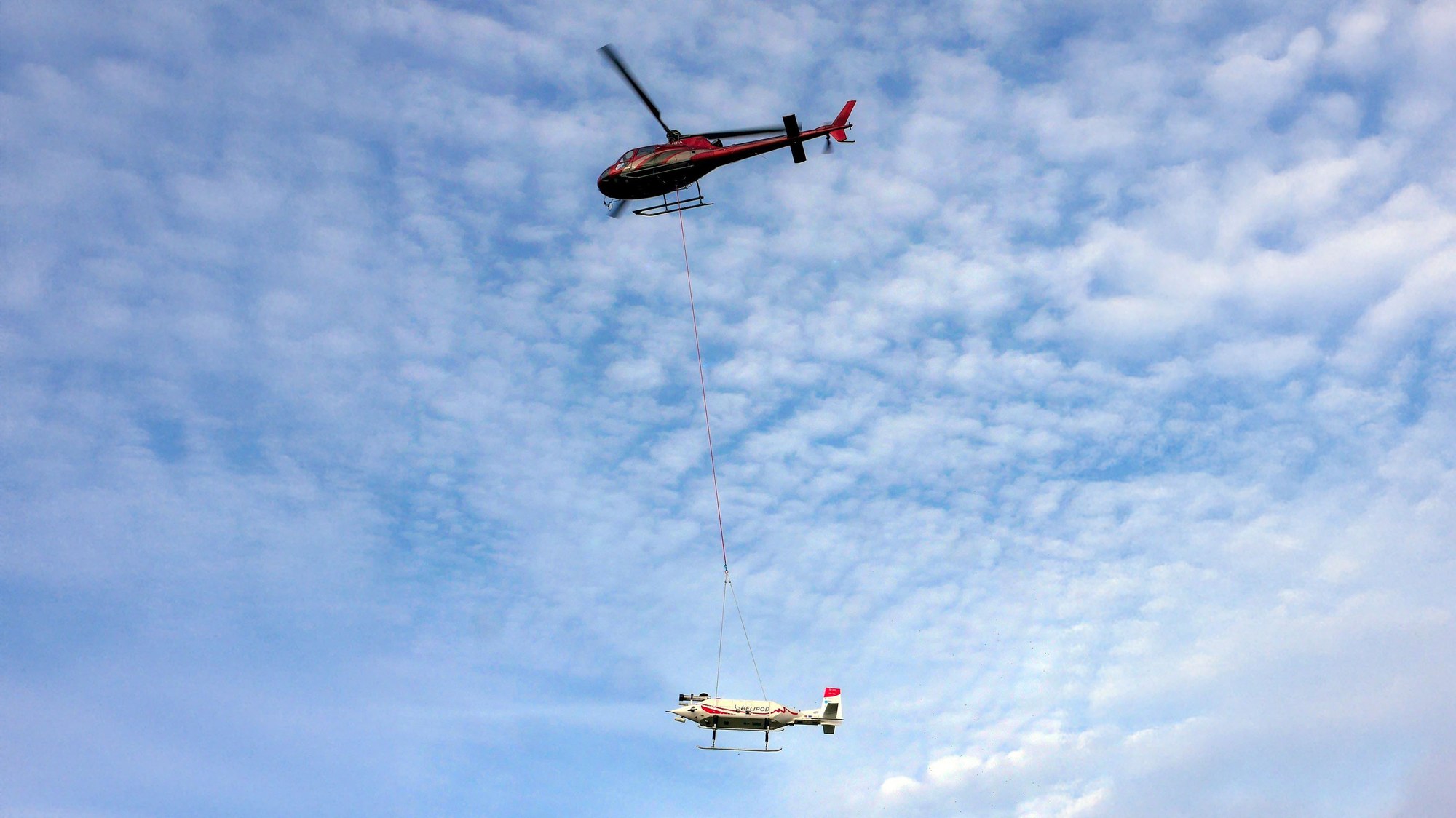
The helicopter and measuring system take off
On 5 October, a helicopter took off from Kohlberg in Poland to fly over the Baltic Sea in the direction of the Nord Stream 1 and 2 pipelines. The HELiPOD, equipped with the measuring instruments for recording methane emissions, hangs below the helicopter.
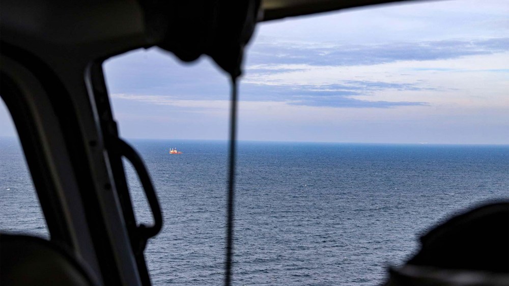
View from the helicopter during the measurement flight over the Baltic Sea
During the flights, the research team was able to take measurements on the upwind (windward) and downwind (leeward) sides of the known locations of the leaks and collect data as low as approximately 50 metres above the sea.
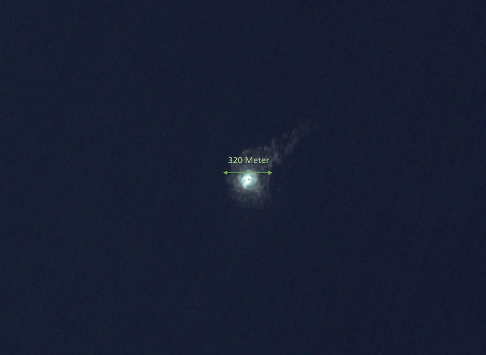
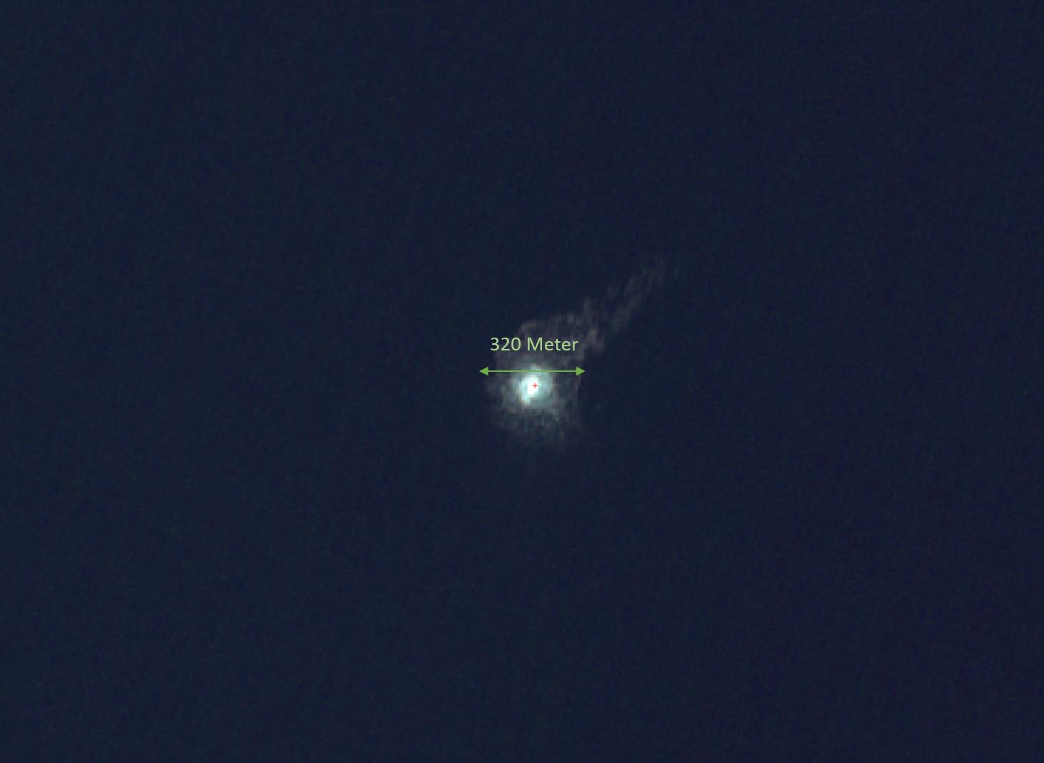
The image taken by the Sentinel-2 satellite on 30 September 2022 shows the Nord Stream 2 gas leak near Bornholm, the extent at this time is about 320 metres.
Image: 6/6, Credit:
Copernicus, ESA, DLR (Beinhaltet modifizierte Copernicus Sentinel-Daten [2022] für Sentinel-2)
The leaks in the Nord Stream 1 and 2 natural gas pipelines in the Baltic Sea have dominated the headlines in the last week. According to initial estimates, between 100 and 500 kilotonnes of methane have flowed into the sea in just a few days. It is still unclear what proportion of the methane remains in the ocean and how much has escaped into the atmosphere. In cooperation with the United Nations Environment Programme, the German Aerospace Center (Deutsches Zentrum für Luft- und Raumfahrt; DLR), the Technical University of Braunschweig and other partners have now successfully measured the methane concentrations in the air directly above the leaks of the Nord Stream pipelines. To do this, the research team equipped a helicopter-borne measurement device with instruments and flew it over the Baltic Sea on 5 October 2022. DLR researchers also analysed radar data and optical satellite images, which confirm the gas leakage at the known leaks and indicate how they are expanding.
"Organised at short notice, DLR's activities related to the analysis of the leaks from the Nord Stream pipelines demonstrate our capabilities and diverse range of available Earth observation techniques," says DLR Divisional Board Member for Space, Anke Pagels-Kerp. "With the flights in the region of the leaks, we will be able to understand more precisely how much methane is still leaking and how it is spreading locally at the leak sites. Radar observations from space offer the potential to monitor our maritime infrastructure more intensively in the future, regardless of cloud cover, weather and time of day."
Measuring instruments hover 50 metres above the sea
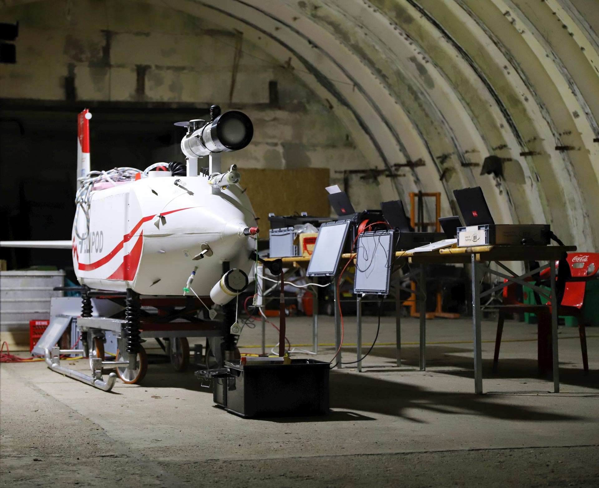
In close cooperation with the Institute of Flight Guidance (IFF) of the Technical University of Braunschweig, a total of two helicopter flights took place starting from the Polish coast near Kohlberg. The IFF operates the HELiPOD device, which is towed by a helicopter and carries a range of instruments for conducting atmospheric measurements. It was previously used in June 2022 for measurements of methane emissions from coal mines in Poland as well as for the MOSAiC international Arctic drift campaign. The HELiPOD is carried as a sling load on an approximately 25-metre-long rope under the helicopter. For the current flights, it was equipped with an additional methane measurement instrument from the DLR Institute of Atmospheric Physics. The Braunchweig branch of the Federal Agency for Technical Relief (THW) provided important support in the short-term logistical preparation for the measurement campaign. The helicopter was provided by the Polish company Helipoland.
The measurement flights were also supported by the IMEO initiative of the UN Environment Programme (UNEP). "The Nord Stream 1 and 2 methane leaks have highlighted the importance of accurately monitoring methane emissions worldwide, at all temporal and spatial scales. UNEP is proud to have supported the measurements carried out by DLR," says Manfredi Caltagirone, Head of the UN Environment Programme's International Methane Emissions Observatory (IMEO), adding: "IMEO will continue to work to make methane emissions data available globally to accelerate the reduction of methane emissions."
HELiPOD with measuring instruments
The IFF operates the helicopter-borne HELiPOD device, equipped with a range of instruments for conducting atmospheric measurements. For these flights over the Baltic Sea, it was equipped with an additional instrument for measuring methane from the DLR Institute of Atmospheric Physics.
The flights allowed measurements to be taken on the upwind (windward) and downwind (leeward) sides of the known locations of the leaks. "In the process, we were able to collect data with the HELiPOD instruments at low altitudes down to approximately 50 metres above sea level," explains the head of the measurement campaign, Anke Roiger from the DLR Institute of Atmospheric Physics. "The detailed measurements of methane concentrations in the vicinity of the leaks will help us to characterise the dispersion of methane emissions from the different leaks and compare them to the existing emission rate estimates. These direct airborne measurements close the observational gap between the ground and satellite observations carried out over the past few days." During the flights, the HELiPOD mission monitor in the helicopter cockpit displayed the recorded measurements wirelessly, allowing the helicopter to successfully fly through the visually invisible methane clouds.
Natural gas consists largely of methane, which is the second most important anthropogenic greenhouse gas, after carbon dioxide. In recent months, DLR measurement flights have investigated methane sources using the HALO aircraft in Canada and the Falcon aircraft on the west coast of Central Africa. In addition to the analysis of emissions from the respective active oil and gas industries, natural sources such as wetlands and thawing permafrost soils were of particular interest. Modern satellites are unable to detect methane from space with a high degree of accuracy, particularly over the sea. In the future, the German-French Methane Remote Sensing Mission (MERLIN) satellite mission will determine regional and global emissions of the greenhouse gas methane from space much more precisely using a laser-based LIDAR sensor developed at DLR.
Satellite observations – potential for monitoring maritime infrastructures
Satellite images from space, acquired by the European radar satellite Sentinel-1A, confirmed the continuous release of gas on 29 and 1 October 2022. The large amount of escaping gas created strong vortexes in the water, which reflected the radar signal more strongly than the surrounding 'calmer' water and are therefore clearly visible in the radar images. Sentinel-1A orbits Earth at an altitude of approximately 700 kilometres in a Sun-synchronous orbit and, thanks to its active radar antenna, can image the ocean surface through clouds and fog regardless of weather and time of day. Images acquired on 30 September by the optical Sentinel-2 mission were also used.
With the unexpected leaks in the Nord Stream pipelines, the continuous monitoring of critical maritime infrastructures is increasingly attracting attention. Weather-independent radar satellites could play an important role in the future. "The necessary satellites, such as Sentinel-1A, but also the German satellites TerraSAR-X and TanDEM-X are already in orbit," explains Stefan Dech, Director of DLR's Earth Observation Center (EOC). In addition, the next Copernicus radar satellite, Sentinel-1C, will be in orbit as early as 2023. "By adapting the observation routines, the satellites could in future also be used to a greater extent to monitor maritime infrastructures, for example to detect unusual ship movements and other anomalies near important maritime installations at an early stage. There is great potential for future monitoring systems and algorithms thanks to the rapid progress in automatic data evaluation and pattern recognition using artificial intelligence." Today, these capabilities are supplemented using optical satellites such as those of the Sentinel-2 mission or Landsat.
In addition to parts of the European Space Agency (ESA) core ground segment, EOC operates its own systems at the DLR site in Neustrelitz for receiving Sentinel data and evaluating them in near-real time. A key use of these data is in the context of maritime security issues. For example, satellite data have long been a basis for monitoring wind and sea conditions as well as for detecting oil spills, hazardous material dumping or illegal fishing.
DLR operates two 'Maritime Safety' research centres at its sites in Neustrelitz and Bremen. Data processing techniques developed in Bremen to detect ships or icebergs using radar satellite images, for example, are integrated and operationalised in the relevant systems developed in Neustrelitz. Researchers on site are also using data from optical satellites to produce integrated solutions that combine various satellite instruments and images.
At the newly established DLR Institute for the Protection of Maritime Infrastructures in Bremerhaven, initial research work is already underway to explore how intelligent situational awareness above and below water can be achieved in the future. These technologies are being tested in close coordination with authorities and operators, taking careful consideration of the wider social context, and prepared for the market.


