Lake Benmore on the South Island of New Zealand


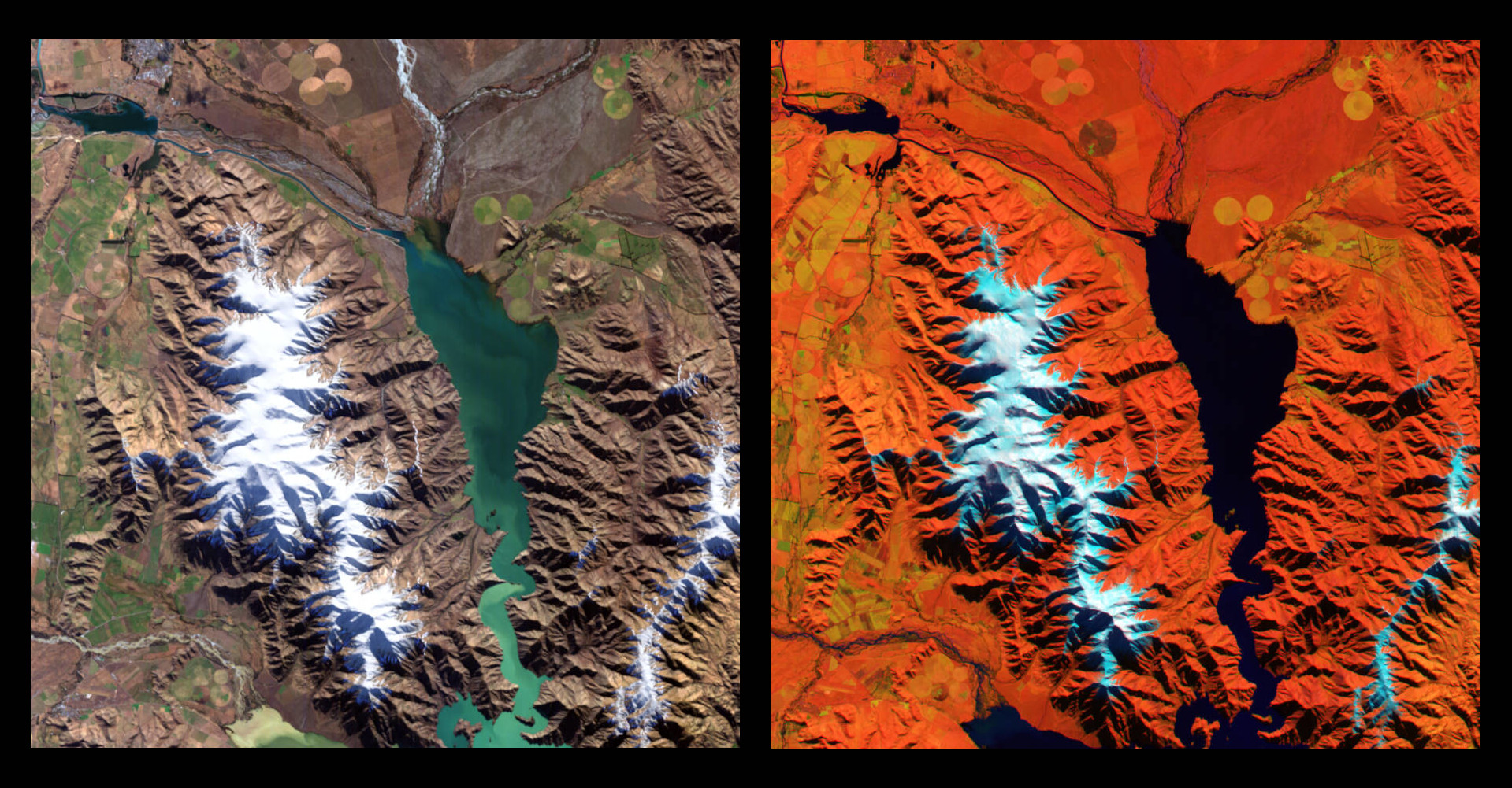
This image shows two views of Lake Benmore and the surrounding mountainous landscape. Lake Benmore (Maori: Te Ao Marama) is a reservoir in the Canterbury region on the South Island of New Zealand. With an area of 74 square kilometres, it is the largest artificial lake in New Zealand. The images were acquired by the German environmental satellite EnMAP, which captured the region on 9 August 2022.
DLR's environmental satellite was launched in April 2022 and is now in routine scientific operation, following the successful completion of its test phase. With its two spectrometers, it analyses the solar radiation reflected from Earth's surface at wavelengths ranging from visible light to short-wave infrared at a spectral resolution that was previously unavailable. From these data, precise statements can be made about the condition of and changes to Earth's surface.
The image on the left is a true colour representation, which roughly corresponds to the perception of the human eye. The reservoir appears in various shades of green to dark blue. The mountain peaks, most of which are over 1000 metres high, are covered in snow. The false-colour image on the right shows the same area in wavelengths from different infrared ranges. Vegetation appears yellowish, open ground appears red and the snow stands out in white-blue. The false-colour image is chosen to represent wavelength ranges that are not visible to the human eye – in this case infrared.
Related links
About the EnMAP mission
The EnMAP (Environmental Mapping and Analysis Program) environmental mission is conducted by the German Space Agency at the German Aerospace Center (Deutsches Zentrum für Luft- und Raumfahrt; DLR) in Bonn on behalf of the Federal Ministry for Economic Affairs and Climate Action (BMWK). OHB-System AG was commissioned with the development and construction of the satellite and the hyperspectral instrument. The mission is under the scientific leadership of the GeoForschungsZentrum Potsdam (GFZ). Three DLR institutes and facilities have been commissioned with the construction and operation of the ground segment: The German Space Operations Center in Oberpfaffenhofen carries out and monitors satellite operations. The German Remote Sensing Data Center and the Remote Sensing Technology Institute receive, calibrate and process and archive the satellite data and make them available for academic research.