False colour image of the topography of the Schiaparelli landing site surroundings. The elevation difference is about 4000 metres between the deepest points of the area in the interior of a conspicuous 15 to 30 kilometre wide crater and the highest regions of the surrounding highlands. The image clearly shows that there are no topographic obstacles in the ESA Schiaparelli module planned landing site. In the lower left quadrant, a large crescent-shaped depression is visible, into which a few branching valleys open from the highlands, where water probably flowed more than three and a half billion years ago. The topography also reveals four 'ghost craters' in the upper half, the edges of which have been almost completely worn away by erosion. Credit: ESA/DLR/FU Berlin - CC BY-SA 3.0 IGO.

False colour image of the topography of the Schiaparelli landing site surroundings. The elevation difference is about 4000 metres between the deepest points of the area in the interior of a conspicuous 15 to 30 kilometre wide crater and the highest regions of the surrounding highlands. The image clearly shows that there are no topographic obstacles in the ESA Schiaparelli module planned landing site. In the lower left quadrant, a large crescent-shaped depression is visible, into which a few branching valleys open from the highlands, where water probably flowed more than three and a half billion years ago. The topography also reveals four 'ghost craters' in the upper half, the edges of which have been almost completely worn away by erosion. Credit: ESA/DLR/FU Berlin - CC BY-SA 3.0 IGO.
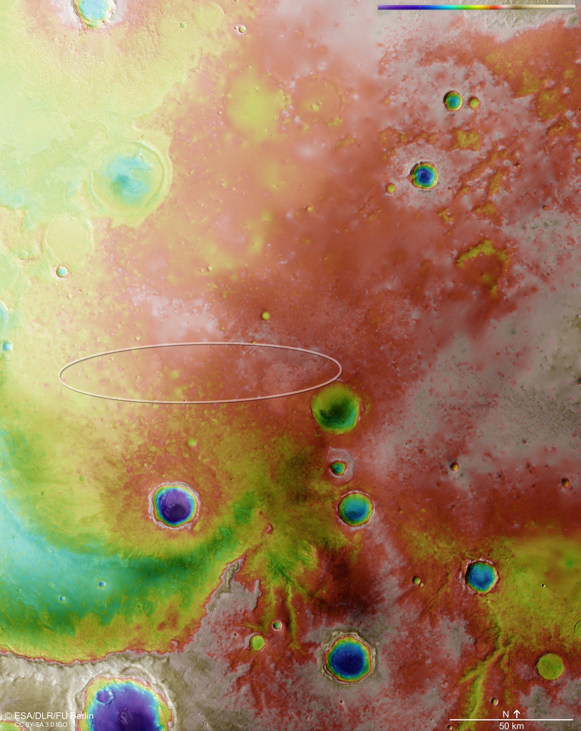
False colour image of the topography of the Schiaparelli landing site surroundings. Digital terrain models of the Martian surface can be generated with an accuracy of up to 10 metres per pixel from the nadir channel directed vertically onto the Martian surface and the stereo channels of the High Resolution Stereo Camera (HRSC) on Mars Express. In this colour-coded illustration, the absolute elevations above a reference level, the Aeroid (derived from Ares, the Greek word for Mars) are depicted. These elevation values can be read based on the legend at the lower right of the image.
 
The elevation difference is about 4000 metres between the deepest points of the area in the interior of a conspicuous 15 to 30 kilometre wide crater and the highest regions of the surrounding highlands. The image clearly shows that there are no topographic obstacles in the ESA Schiaparelli module planned landing site. In the lower left quadrant, a large crescent-shaped depression is visible, into which a few branching valleys open from the highlands, where water probably flowed more than three and a half billion years ago. The topography also reveals four ‘ghost craters’ in the upper half, the edges of which have been almost completely worn away by erosion.
Credit:

ESA/DLR/FU Berlin - CC BY-SA 3.0 IGO.

DownloadDownload