Metamorphosed by climate change – the southern area of Phlegra Montes
February 19, 2015
Metamorphosed by climate change – the southern area of Phlegra Montes
Colour view of the south of Phlegra Montes
This image was generated from the HRSC nadir channel and the colour channels. The shading of the predominant ochre colour indicates differences in the material in the plain, which is made of solidified lava flow. The variations in the roughness of the surface between the individual mountains of Phlegra Montes, are evidence that different geological processes such as landslides or former glaciation have contributed to the formation of the landscape.
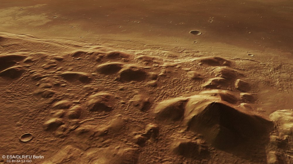
Perspective view of Phlegra Montes on the Elysium volcanic plain
Perspective views of the surface of Mars can be derived from digital terrain models of the HRSC image data. In the background it can be seen how – millions of years ago – non-viscous lava ‘surged’ against the obstruction caused by the very much older Phlegra mountains and solidified. These lava flows probably came from the volcano Hecates Tholus. Isolated mountains with rounded shapes project out from the high plateau in the foreground. The relief between the hills and mountains has been marked by landslides and the movements of ice in the course of earlier glaciation.
Topographical image map of the southern region of Phlegra Montes
Digital terrain models can be derived from the HRSC imaging system’s stereo image data, which allocate an altitude value to each pixel on the surface of Mars. The reference level for the altitude values is an ‘areoid' (named after Ares, the Greek name for Mars), a notional plane of equal gravitational attraction that corresponds to sea level on Earth. The distribution of altitude values can be seen using the colour scale in the upper right of the image.
The highest uprisings of the southern Phlegra Montes extend some 2500 metres upwards from the volcanic plain of Elysium and are interrupted by plateau-like uplands. In the centre of the image, several small valleys running from west to east and ending in a basin-shaped structure can be seen on the flanks of a group of small hills.
The mountain massif of Phlegra Montes extends into the northern lowlands of Mars like a long, slightly curved salient. Stretching for hundreds of kilometres, this alignment of numerous mountains, rolling hills and ridges lies to the east of the volcano Hecates Tholus in the Elysium volcanic region. This geological formation provides insights into the metamorphosis of a landscape marked by changes to the Martian climate millions of years ago. The images shown here were acquired by the High Resolution Stereo Camera (HRSC) on board ESA's Mars Express spacecraft, which is operated by the German Aerospace Center (Deutsches Zentrum für Luft- und Raumfahrt; DLR).
Mars' rotational axis – inclined at an angle of 25.2 degrees relative to the planet's plane of motion around the Sun – is similar to Earth's. The Red Planet experiences comparable variations in the amount of solar radiation depending on the latitude and time of year. But these changes are less pronounced, due to the planet’s greater distance from the Sun. At 30 and 50 degrees north, Phlegra Montes sits in the temperate latitudes of Mars; on Earth, this would be comparable to a range of mountains stretching from North Africa to Frankfurt.
This has not always been the case with this climatic zone. It is now known that Mars' rotational axis inclination is subject to severe variations. At times, its tilt has increased to 60 degrees, and then reduced again; the solar radiation at different latitudes has not been constant for millions of years in the way that it has been on Earth. This means that the climate has varied extremely from place to place throughout time.
Video
The History of the Climate of Mars
Your consent to the storage of data ('cookies') is required for the playback of this video on Youtube.com. You can view and change your current data storage settings at any time under privacy.
The History of the Climate of Mars
Video
Credit:
DLR
Traces of temporary, complete glaciation
The consequence of extreme climatic variation is visible in the traces of activity involving polar ice that are found not only at the current Martian poles, but also at temperate latitudes, and even near the equator. Massive glaciation must also have occurred in Phlegra Montes at some time in the past, as can be seen very clearly in the article published on 2 December 2011. These new images of Phlegra Montes were acquired on 8 October 2014 during Mars Express orbit 13,670. The centre of the images is at 160 degrees east and 31 degrees north.
Knowledge of these basic conditions helps to better understand the features we see in Phlegra Montes today, which are partially the result of climate change and its effects. Radar measurements acquired when looking for evidence of subterranean ice layers and investigations of the landscape lead numerous scientists to believe that the region must have been heavily glaciated hundreds of millions of years ago. Based on crater frequency measurements, the age of Phlegra Montes has been limited to 3.91 to 3.61 billion years; this implies that the mountain range is much older than the surrounding lowlands.
Lava flows from the volcano Hecates Tholus – 400 kilometres away?
The HRSC images show the southern foothills of Phlegra Montes. The western area (upper half of the picture in images 1, 3 and 5) is dominated by a plain of smooth material that reaches the mountains and covers their base. Closer inspection reveals several wrinkle ridges that were formed during the cooling of non-viscous basaltic lava. It is possible that the lava that forms this plain originates from the volcano Hecates Tholus, which lies some 450 kilometres to the west and was presented in this image series on 1 March 2004, at the beginning of the Mars Express mission.
Several small valleys running from west to east and ending in a basin-shaped structure can be seen on the flanks of a group of small hills in the centre of images 1, 3 and 5. The material that was deposited in this depression looks different to that on the mountain slopes; it appears to be more affected by erosion than the surroundings. On the hills lying farthest to the east (lower edge of the image), this material bulges out in places at the foot of these mountains, indicating the occurrence of landslides of entire layers of rock on the mountain slopes lying to the west.
The HRSC experiment
The High Resolution Stereo Camera was developed at DLR and built in collaboration with partners in industry (EADS Astrium, Lewicki Microelectronic GmbH and Jena-Optronik GmbH). The science team, which is headed by principal investigator (PI) Ralf Jaumann, consists of 52 co-investigators from 34 institutions and eleven countries. The camera is operated by the DLR Institute of Planetary Research in Berlin-Adlershof.
Image processing
The images were acquired by the High Resolution Stereo Camera (HRSC) on 8 October 2014 during Mars Express orbit 13.670 at 160 degrees east and 31 degrees north. The image resolution is around 18 metres per pixel.
The colour image (image 1) was acquired using the nadir channel of the HRSC, which is directed vertically down onto the surface of Mars; the perspective oblique view (image 2) was computed from the HRSC stereo channels. The anaglyph image (image 3), which creates a three-dimensional impression of the landscape when viewed with red/blue or red/green glasses, was derived from the nadir channel and one stereo channel. The colour-coded aerial view (image 5) is based on a digital terrain model of the region, from which the topography of the landscape can be derived.