A virtual flight over Atlantis Chaos on board Mars Express
July 29, 2015
A virtual flight over Atlantis Chaos on board Mars Express
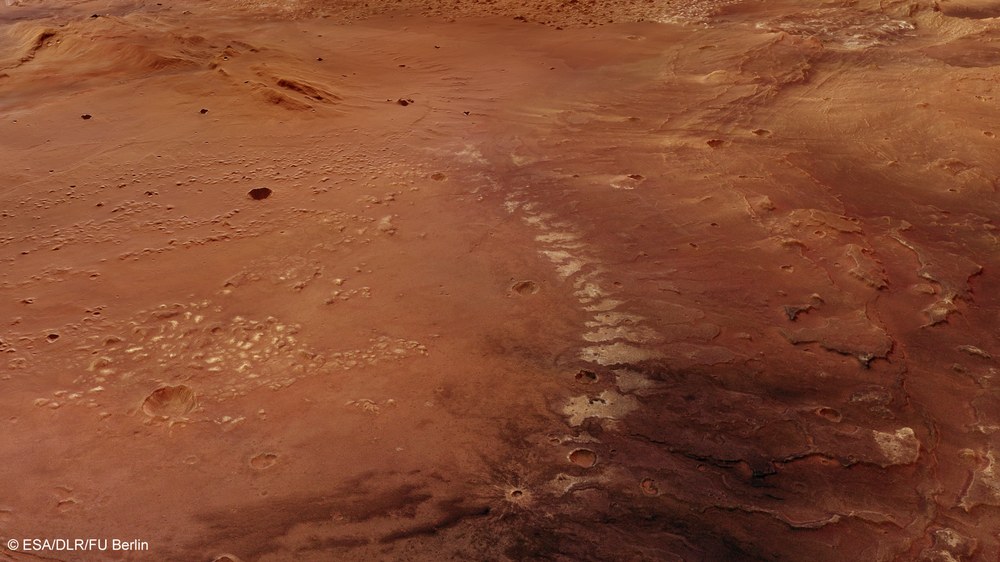
Stratified deposits in the south of the Atlantis basin
The perspective view based on the digital terrain models created using HRSC stereo image data clearly shows the tips of layers poking through the eastern slopes of the Atlantis basin (in the background) and in a smaller depression in the south. The light-coloured deposits consist of hydrous clay minerals.
Copyright note:
As a joint undertaking by DLR, ESA and FU Berlin, the Mars Express HRSC images are published under a Creative Commons licence since December 2014: ESA/DLR/FU Berlin, CC BY-SA 3.0 IGO. This licence will also apply to all HRSC images released to date.
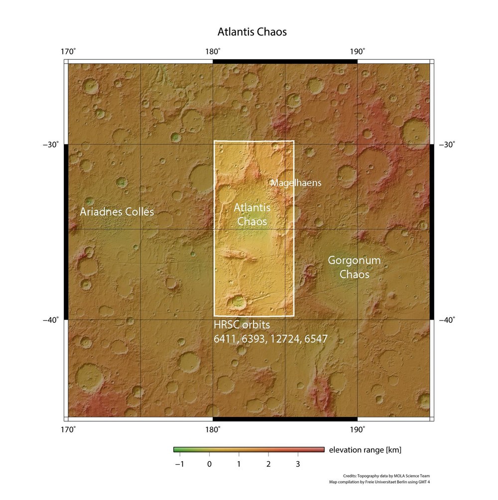
Topographical context map of the Terra Sirenum region in the Martian Highlands
Atlantis Chaos is located in a circular plain with a diameter of roughly 200 kilometres; the Atlantis basin in the southern reaches of the Martian Highlands, located at around 34 degrees south and 183 degrees east, may have been part of a large body of standing water, Eridiana Lake, on the Terra Sirenum plateau.
Countless myths have been woven around the legendary realm of Atlantis. Circa 350 BC, the philosopher Plato depicted a maritime power situated in Atlantis that controlled broad areas of Europe and Africa. It was most likely an island whose inhabitants ruled over the people living in the multiple regions bordering the Mediterranean. Suddenly, Atlantis disappeared without a trace – leaving behind what continues to be one of the greatest mysteries faced by archaeology. A large area on Mars has been named after this realm, and displays a clearly visible, tumultuous geological history: the Atlantis basin.
A virtual flight across the area known as Atlantis Chaos reveals a broad variety of phenomena, etched into this landscape billions of years ago. Scientists at the Planetary Sciences and Remote Sensing section of the Institute of Geological Sciences of the Freie Universität Berlin, created the animation based on a digital terrain model calculated using four image strips acquired between 2008 and 2014 by the High Resolution Stereo Camera (HRSC) operated by the German Aerospace Center (Deutsches Zentrum für Luft- und Raumfahrt; DLR) on board the European Space Agency (ESA) Mars Express spacecraft.
Mars Express: Ein virtueller Flug über "Atlantis Chaos"
Mars Express: Ein virtueller Flug über "Atlantis Chaos"
Your consent to the storage of data ('cookies') is required for the playback of this video on Youtube.com. You can view and change your current data storage settings at any time under privacy.
Mars Express: Ein virtueller Flug über "Atlantis Chaos"
Mars Express: Ein virtueller Flug über "Atlantis Chaos"
Credit:
DLR
This area, originally described in 1930 on a map of Mars by the Greek astronomer Eugène Michel Antoniadi, is situated at approximately 183 degrees East and 34 degrees South. Atlantis basin is most likely the remains of a 200 kilometre-wide impact structure in the Sirenum Terra region, in the southern highlands of the Red Planet. But the circular profile indicating a possible crater rim has all but disappeared. Images of Atlantis Chaos were published on the DLR Portal on 12 June 2014.
'Chaotic' traces of sediment from Eridania Lake
First, the virtual flight takes us above a relatively well-preserved crater bearing traces of sediment at the base and showing visible fissures. Then, we fly over a straight section of a valley of tectonic origin, with rifts on both sides, before continuing across a plain with light-coloured sedimentation and a number of flow fronts consisting of solidified, low-viscosity lava. We are then taken across a large, 'chaotic area' with a number of light-coloured mesas, before entering a mountainous region, up to 2000 metres in height.
It is possible that standing water once filled the Atlantis basin and the adjoining depressions, which include several impact craters dating back three to four billion years: Eridania Lake. It could even have covered an area of over one million square kilometres, making it roughly half the size of the Mediterranean. Ma'adim Vallis – a roughly 700-kilometre outflow channel though to have carried water northwards from the lake to form a deeper-lying expanse in Gusev crater – opens up northwest of Eridania: the antique name for Po Mountain and the Po Valley in Italy. It was there, in the 166-kilometre Gusev crater, where the NASA Rover Spirit landed in January 2004 before beginning its exploration, which lasted until March 2010.
Scarred by water and the wind
The wildly creviced and strongly structured landscape of Atlantis Chaos is situated in Atlantis basin. It consists of several hundred light-coloured small peaks and mesas distributed across a nearly circular lowland plain. These are most likely remnants of so-called outliers, testimonies to what once was a continuous high plateau, which has since been largely whittled away by erosion. Originally, it may have consisted of sedimentary deposits that were carried into the basin by the wind and subsequently altered by the influence of water. Here on Earth, this kind of sediment layer is referred to as 'loess'. In China, there are loess deposits with thicknesses of up to 400 metres.
The landscape we pass over extends for almost 600 kilometres along a north-south axis and 250 kilometres along an east-west axis – roughly two-and-a-half times the size of Florida. A kind of channel connects the Atlantis basin to another basin located further south (left of images 1, 4 and 5) with a diameter of 175 kilometres. Chaotic remnants of a number of former mountains are spread out across this circular depression, covered with light-coloured material like those in the neighbouring Atlantis basin.
Image processing
The scene was put together using four strips of images produced by the High Resolution Stereo Camera (HRSC) during orbits 6393, 6411, 6547 (2008/2009) and 12,724 (2014). The centre of the scene overflown is located at approximately 34 degrees South and 183 degrees East. The image resolution of the high-resolution nadir channel, which has been incorporated into the calculation of the digital elevation model, is roughly 14 metres per pixel. The colour plan view (image 1) was acquired using the nadir channel, which is directed vertically downwards onto the surface of Mars, combined with the colour channels.
The HRSC experiment
The High Resolution Stereo Camera (HRSC) was developed at DLR and built in collaboration with industrial partners (EADS Astrium, Lewicki Microelectronic GmbH and Jena-Optronik GmbH). The science team, which is headed by Principal Investigator (PI) Ralf Jaumann, consists of 52 co-investigators from 34 institutions in 11 countries. The camera is operated by the DLR Institute of Planetary Research in Berlin-Adlershof.
