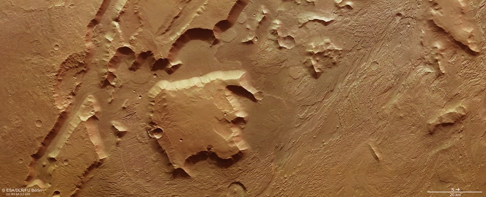
Acquired in true colour, this image shows a section of Aeolis Mensae measuring approximately 180 by 80 kilometres in the transition zone between the Martian highlands and the northern lowlands. North is on the right of the image. The almost linear tectonic grabens typical of the region are clearly visible on the left of the image. They are what caused the over 2500-metre mesas scattered across across the landscape. Tectonic movement has made the edges of the terrain extremely steep, which results in frequent landslides. The material deposited by these is easily visible as a number of protrusions along the terraced sections of steep rock. In contrast, the right-hand side of the image shows a landscape scarred by exposure to the erosive power of the winds that have buffeted the surface of Mars at high speed for long periods. Elongated ribs of rock as yet untouched by erosion – yardangs – indicate the direction of prevailing winds.
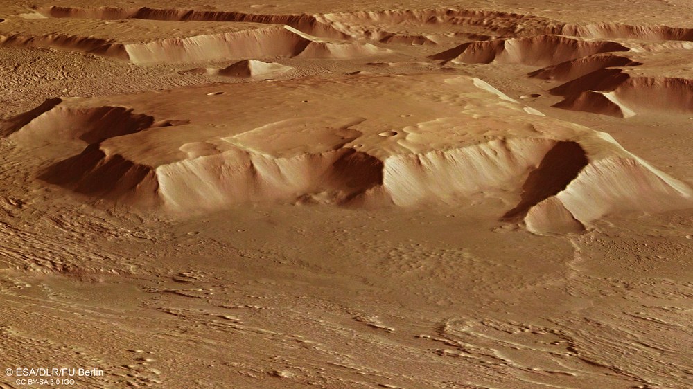
Oblique perspective view of a mesa in Aeolis Mensae
Measuring 40 by 40 kilometres, the 2500-metre-high mesa protrudes like a small mountain from Aeolis Mensae in the transition zone between the northern lowlands and the southern hemisphere of Mars. Traces of wind erosion – referred to as yardangs – are visible in the foreground. They indicate the prevailing wind direction in this region of Mars, which runs southeast to northwest. There are other mesas in the background of the image, together with an older impact crater, the nearest edge of which has been eaten away by tectonic processes and erosion, allowing a view of the terraced rim of the crater on the opposite side.
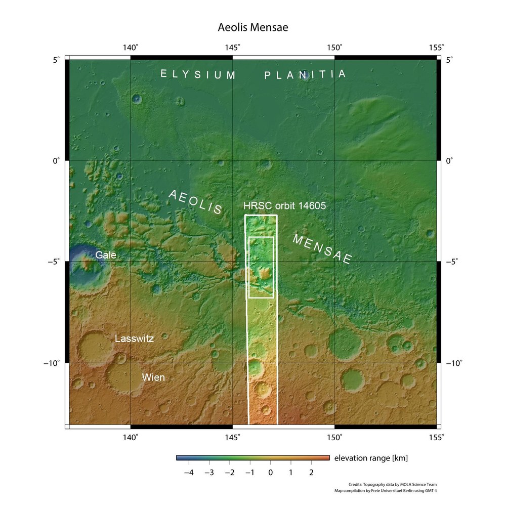
Topographic overview map of the Aeolis Mensae region
Located between 140 and 150 degrees east, Aeolis Mensae is a transition zone between the southern highlands of Mars and the northern lowlands. The area is characterised by numerous large mesas that protrude like icebergs from the southern section of Elysium Planitia. Aeolis Mensae takes its name from an ancient landscape on the west coast of modern Turkey. Travelling at an altitude of approximately 360 kilometres, Mars Express passed over the eastern section of Aeolis Mensae on 7 July 2015, where it used the High Resolution Stereo Camera (HRSC) to acquire the image data presented here (small rectangle within the highlighted strip of the image).
One of the most striking features of a global view of Mars is the dichotomy between the topographically diverse highlands in the southern hemisphere and the flat, expansive lowland plains of its northern counterpart. Many landscape features shaped by erosion can be observed in the transitional zone between the highlands and lowlands, which explains the particular geological interest in this region. The images presented here show mesas in Aeolis Mensae alongside formations carved by intense wind erosion as the terrain transitions gradually into the lowlands.
The image data was acquired by the High Resolution Camera System (HRSC), developed and operated by the German Aerospace Center (Deutsches Zentrum für Luft- und Raumfahrt; DLR) on board the European Mars Express spacecraft. The region is situated roughly 400 kilometres east of Gale Crater, where NASA's Mars Science Laboratory touched down in 2012 carrying the rover Curiosity. The image resolution is approximately 15 metres per pixel.
Wind and water erode the landscape
Numerous fracture zones known as tectonic grabens cross the region. Expansion of the Martian crust produced a large number of freestanding mesas (sometimes called witness buttes), the plateaus of which indicate that the highlands of Mars once extended further to the north. A large expansion fracture extends diagonally through the image in the south of this scene, on the left-hand side of the image (north is on the right in these images). The large mesa in the centre of the image, which measures approximately 40 by 40 kilometres and rises some 2500 metres above the surrounding terrain, is a remnant of these expansion processes. Its top is at the same elevation as the adjacent Hesperia Planum highland region further to the south.
Wind, and possibly also water and ice, have eroded the landslides and weathered the rock over millions of years, so the mesas become smaller and will disappear in the distant future. In the north, in the right-hand section of images 1, 3 and 4 it becomes apparent that wind is the 'shaping force' on Mars; the landscape there shows a characteristic pattern of small ribs, referred to as yardangs. These are produced when the wind blows from a prevailing direction over a long period of time, carrying sand and particles of dust that scour 'wind gullies' into the rocky surface. The word yardang is taken from the Uyghur language, which describes steep walls of sand and wind gullies in the desert around Lop Nor.
Video on the weather and climate on Mars. In this interview, Daniela Tirsch, a planetary geologist at the DLR Institute of Planetary Research, explains how wind and weather continue to leave their mark on the surface of Mars today.
The weather and climate on Mars
Your consent to the storage of data ('cookies') is required for the playback of this video on Youtube.com. You can view and change your current data storage settings at any time under privacy.
The weather and climate on Mars
Video on the weather and climate on Mars. In this interview, Daniela Tirsch, a planetary geologist at the DLR Institute of Planetary Research, explains how wind and weather continue to leave their mark on the surface of Mars today.
Most of the yardangs run in a southeasterly to northwesterly direction, which is indicative of the prevailing winds in this region. A small, steep-sided rib in the terrain, extending for around 7.5 kilometres perpendicular to the main direction of the yardangs, is an eye-catching feature of this area. Quite evidently, the rib is made of harder and far more resistant rock that allows it to withstand the erosive power of the wind. It is possible that a minor expansion fracture formed transversely to the principal tectonic orientation and was then filled with molten volcanic rock that became harder than the surrounding material after solidification.
At Christmas, Mars Express will have spent 13 years in orbit
In just a few days, Mars Express will celebrate the thirteenth anniversary of its arrival at Mars. When the ESA spacecraft entered orbit around the Red Planet on Christmas Day 2002, its mission was designed to last just two Earth years (or one Martian year). But the extensive scientific yield prompted its extension on multiple occasions, most recently to the end of 2018. ESA's first planetary mission is therefore also the longest to date. HRSC has mapped approximately 90 percent of Mars' surface – equivalent to 150 million square kilometres, or approximately the area of all Earth's continents combined – with high-resolution stereo images and in colour. Image data representing around two thirds of the surface have already been rendered to produce a digital terrain model with a precision of 40 metres per pixel or better. The objective of this camera experiment is to compute a digital terrain model covering the entire surface of Mars.
Image processing
The HRSC system acquired these images on 7 July 2015 from an altitude of approximately 360 kilometres during Mars Express orbit number 14,605. The data was processed by scientists from DLR and the Planetary Sciences and Remote Sensing Department at Freie Universität Berlin. The region is located at five degrees south and 146 degrees east. The image resolution is approximately 15 metres per pixel. The colour plan view (image 1) was produced by the nadir channel, which is directed vertically down onto the surface of Mars, along with the colour channels; the oblique perspective image (image 2) was calculated using data acquired by the HRSC stereo channels. The anaglyph image (image 3), which conveys a three-dimensional impression of the landscape when viewed through red-blue or red-green spectacles, was composed using data acquired by the nadir channel and one stereo channel. The colour-coded plan view (image 4) is based on a digital model of the regional terrain, from which the landscape topography can be derived.
The HRSC experiment
The High Resolution Stereo Camera (HRSC) was developed at DLR and built in collaboration with industrial partners (EADS Astrium, Lewicki Microelectronic GmbH and Jena-Optronik GmbH). The science team, which is headed by Principal Investigator (PI) Ralf Jaumann, consists of 52 co-investigators from 34 institutions in 11 countries. The camera is operated by the DLR Institute of Planetary Research in Berlin-Adlershof.
