Earth as seen from space at the Gasometer Oberhausen
March 10, 2016
Earth as seen from space at the Gasometer Oberhausen
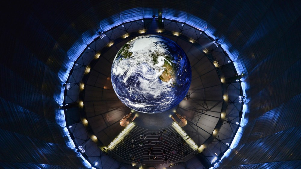
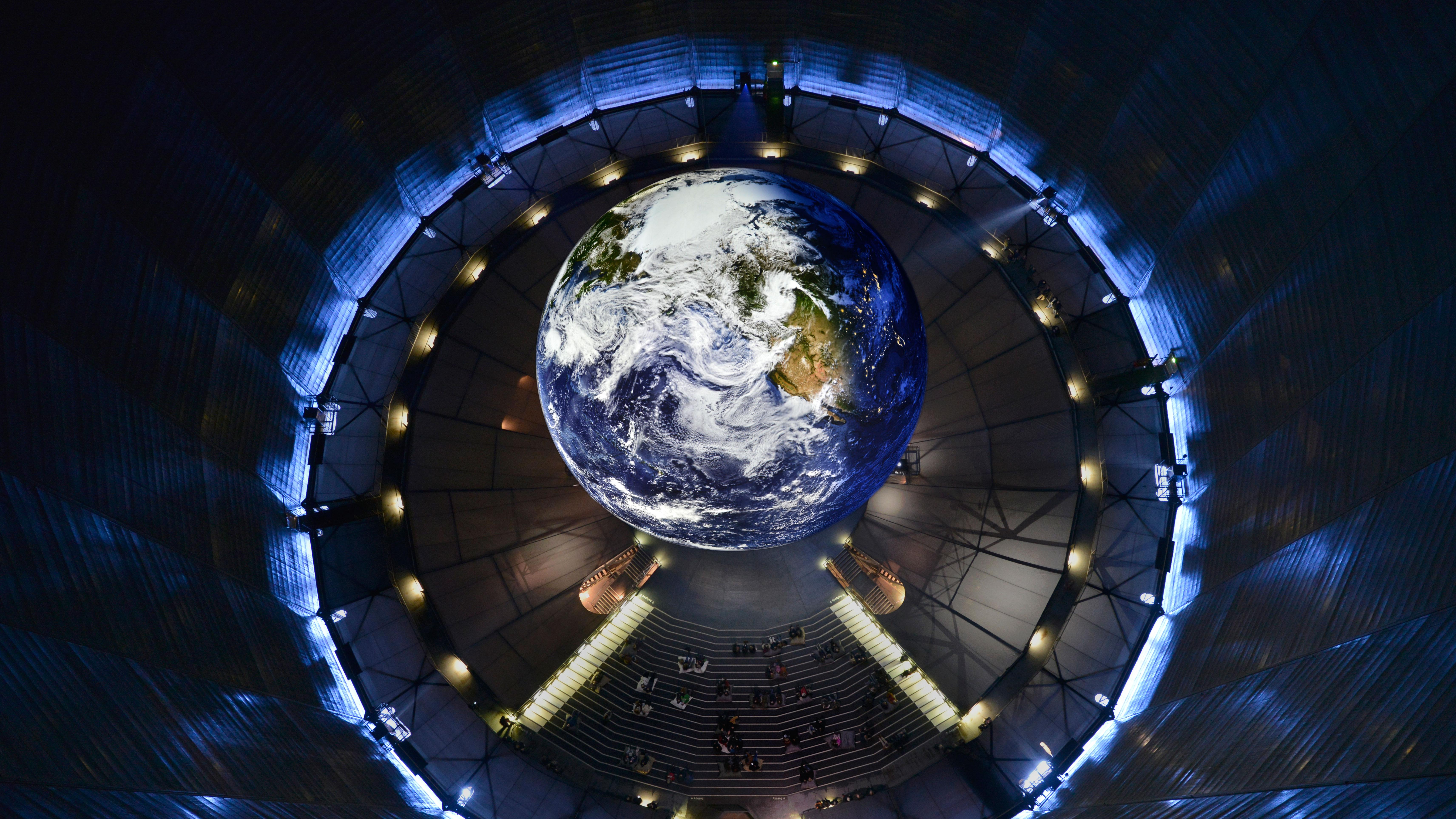
A lift that rises above the Earth
The glass-panelled lift in the Gasometer Oberhausen gives visitors a view of Earth usually exclusive to astronauts. DLR acquired satellite data to produce an animation that is projected onto the 20-metre diameter globe.
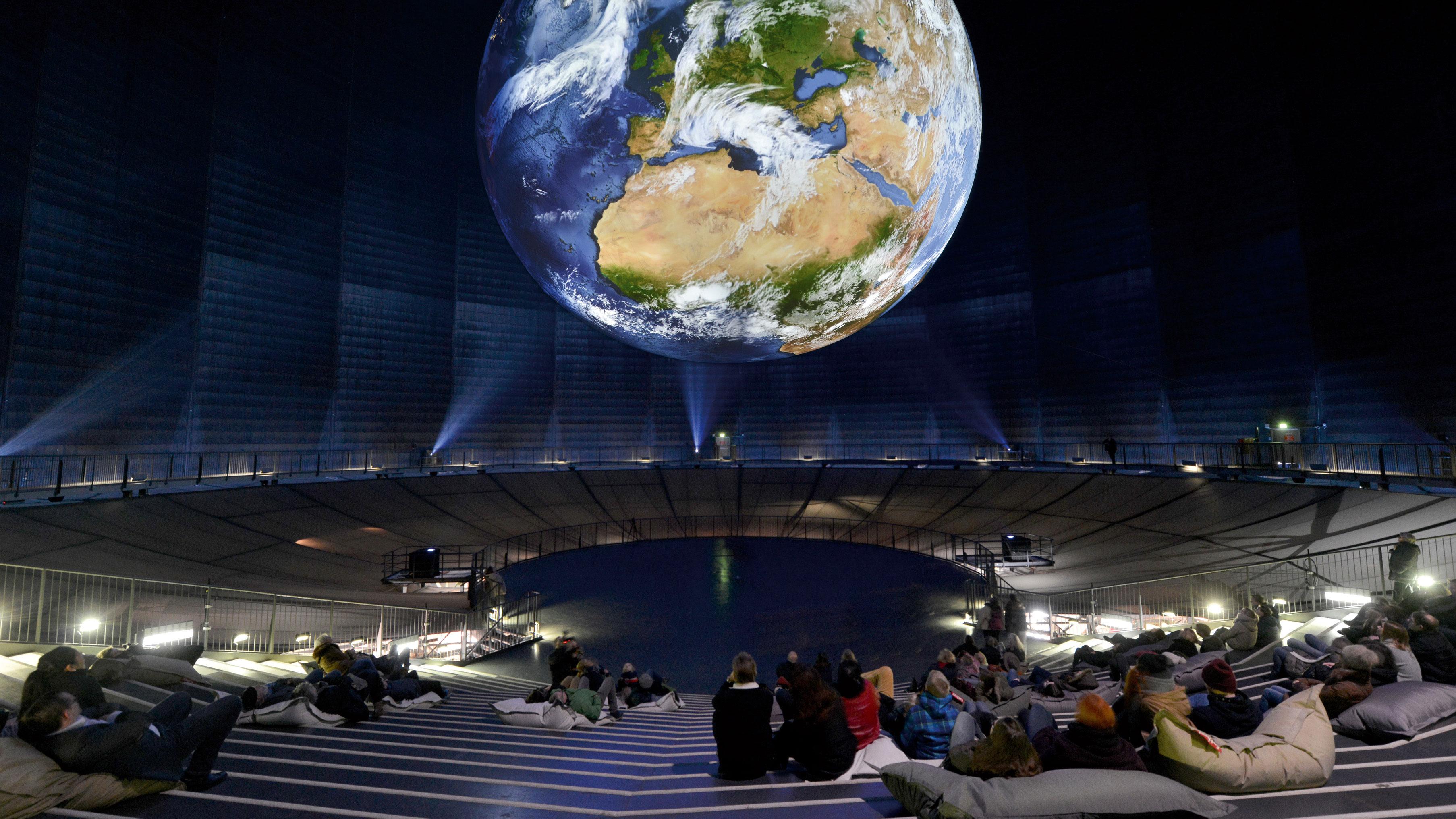
The Wonders of Nature exhibition in the Gasometer Oberhausen features a floating Earth. Among other things, the DLR animation shows air currents criss-crossing the planet and even the changes between day and night.
When it comes to the best views of Earth, weather satellites usually have front-row seats. But now, and until 30 December 2016, everyone can enjoy this very special view of the Blue Planet at the Gasometer Oberhausen. The highlight of the 'Wonders of Nature' exhibit is a terrestrial globe 20 metres in diameter hovering from the 100-metre high tower of this imposing industrial monument. The German Aerospace Center (Deutsches Zentrum für Luft- und Raumfahrt; DLR) created a piece-for-piece and layer-by-layer animation using satellite data that is projected onto the globe by 12 projectors. "Our aim is, first of all, to show the beauty of Earth and also to make it possible to view Earth as if from space," says Nils Sparwasser of the DLR Earth Observation Center. To do that, researchers generated 1.5 million photos. The result is a globe on which day alternates with night and bands of clouds make the air currents around the Earth visible. If you ride up the inside wall of the gasometer with the panoramic elevator, it is as if you were looking at the Earth from a distance of 36,000 kilometres. The Gasometer Oberhausen also has 150 large-format photographs of animals and plants on display by renowned photographers such as Frans Lanting, Rob Kesseler, Tim Flach and Anup Shah.
Big picture puzzle
"I don't know of any larger artificial Earth like this one," explains Sparwasser. The project started off with several data sets from the most diverse satellites – with and without cloud cover, at day and night time, and with phenomena unperceivable to the human eye. "It was a challenge to collect this data and create the best possible animation out of it." The big picture emerged gradually out of particular pieces and information derived from remote sensing data and radar satellites of the SRTM mission, as well as measurements from weather satellites. All the pieces of the puzzle were calibrated against each other and put together, "and all of that yielded a 3D representation of the Earth." The computers processed all the data round-the-clock for a total of 115 days to create the animation with a 58 million-pixel resolution.
Video
Produktion der Erdskulptur für die Ausstellung "Wunder der Natur"
Your consent to the storage of data ('cookies') is required for the playback of this video on Youtube.com. You can view and change your current data storage settings at any time under privacy.
Produktion der Erdskulptur für die Ausstellung "Wunder der Natur"
Intermediate Engineering, the company responsible for technical implementation, gave the DLR team the exact positioning information for the 12 projectors. This information was then fed into a virtual Gasometer, as cameras that filmed the 3D model of the Earth. In that way each projector obtained its own animation, and all of them together generate a seamless picture of the Earth. Looking at the hovering globe, we can see the information that can be obtained from remote sensing data. "For example, you see the rain shed by the clouds in the tropics as black spots," says Sparwasser. For curator Peter Pachnicke, the cooperation with DLR brings two things together: “It is the encounter of a scientific world of images with a poetic way of seeing."
Satellite photos can show details in the range of a few centimetres and wavelengths that are invisible to the human eye. "The remote sensing data show us not only the beauty of Earth," says Sparwasser. "Satellites, for example, continuously provide us with information about carbon dioxide content and the pollution of the oceans; in other words, we are able to get information about our planet's state of health."


