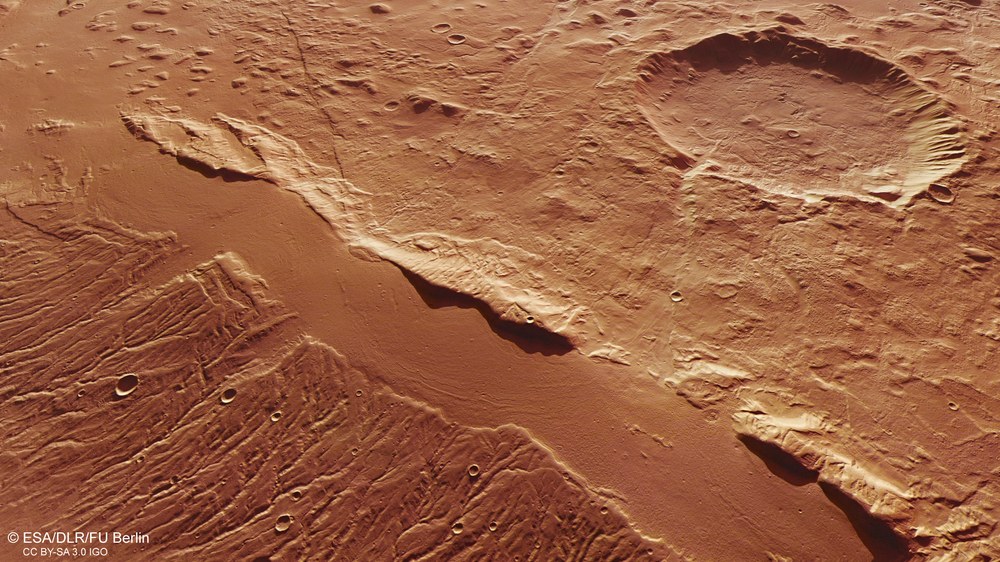
The region around Acheron Fossae is a classic example of a tectonic structure known as a horst and graben system: As a result of the expansion of the crust, large blocks slide along normal fault surfaces into the deformable rock mantle and form graben. The ridges that remain standing between them then form the ‘horsts’. This image shows one of the many filled graben in this region.
This filled graben is located in the Acheron Fossae area on Mars. The region is crossed by arched graben and parallel ridges. These tectonic graben are filled with material that traces previous flow movements of masses of ice and gravel, and indicates the former existence of so-called block glaciers.
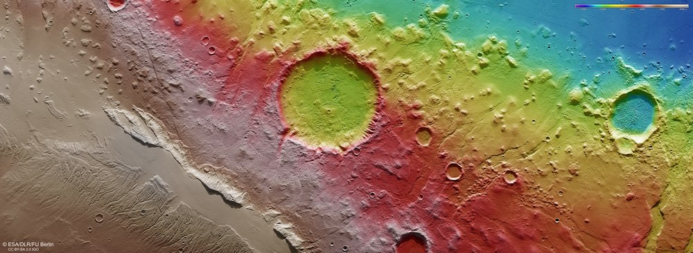
False colour image of the topography of the Acheron Fossae
Digital terrain models of the Martian surface can be generated with an accuracy of up to 10 metres per pixel from the nadir channel directed vertically onto the Martian surface and the oblique views of the stereo channels of the High Resolution Stereo Camera (HRSC) on Mars Express. In this colour-coded image, the absolute elevations above a reference level, the Aeroid (derived from Ares, the Greek word for Mars), are well depicted. These elevation values can be read based on the colour scale at the top right of the image.
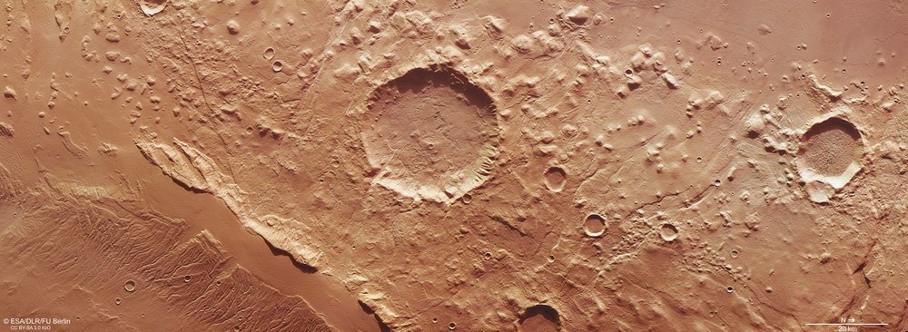
These images, acquired by the High Resolution Stereo Camera (HRSC) operated by the German Aerospace Center (Deutsches Zentrum für Luft- und Raumfahrt; DLR) on board the European Mars Express spacecraft show the western part of Acheron Fossae, a network of fractures on Mars.
Acheron Fossae (Latin for the Acheron graben, Acheron meaning 'black river', also the river of the dead in Greek mythology) is an area immediately north of Mars' largest volcano, Olympus Mons. It is elevated about two kilometres above the surrounding area and covers an area of 800 by 280 kilometres. The area is criss-crossed by arched graben and parallel ridges. This graben system was formed 3.9 to 3.7 billion years ago by an extension of the crust, and therefore by blocks of rock drifting apart.
Criss-crossed by arched graben and parallel ridges
The grabens are filled with material that traces earlier material flow movements and could point to the existence of block glaciers. These are ice streams that were covered by rock rubble and possibly deposited during a cold period within the last million years, after the graben formed. Image 3 shows an example of this type of graben.
The region around Acheron Fossae is a classic example of a tectonic structure, which in geology is called a horst and graben system: As a result of the expansion of the crust, large blocks slide downwards along the normal fault surfaces into the deformable rock of the mantle and form graben between the remaining bridges (the horsts).
Such tectonic patterns also exist on Earth and are usually found along the break line between two continents as they drift apart. They are referred to as a 'rift zone'. A recent example is the Kenya Rift in East Africa. In geological prehistoric times, the Upper Rhine Plain (Oberrheingraben) between Basel and Karlsruhe also formed in this way. On Earth, horst and graben structures are often found in or on the edge of volcanically active regions, just like on Mars.
In contrast to Earth, where graben systems are associated with plate tectonics, on Mars they probably originated from regional areas of tension caused by differences in the composition of the subsoil. The studies of rift zones on Mars are important for understanding the thermal history of the planet and, in particular, the development of the crust, because there were never any plate tectonics on Mars. Mars is a one-plate planet. This means that its crust is not subdivided into individual lithospheric plates but rather consists of one piece. Tectonic processes are triggered here only by tensions in the subsoil, for example by volcanic activity. Studies of the topography and the geological formations of tectonic structures provide important clues with regard to the characteristics of the crust and the upper rock mantle of the planet.
Image processing
The images were acquired by the HRSC (High Resolution Stereo Camera) on 4 May 2016, during Mars Express Orbit 15641. The image resolution is 18 metres per picture element (pixel). The centre of the image is at approximately 142 degrees east and 36 degrees north. The colour plan view was created using data from the nadir channel, which is oriented perpendicular to the surface of Mars, and the colour channels. The oblique perspective view was derived from data acquired by the stereo channels. The anaglyph, which gives a three-dimensional impression of the landscape when viewed with red-blue or red-green glasses, was produced using data from the nadir channel and one stereo channel. The colour-coded map is based on a digital terrain model (DTM) of the region, from which the topography of the landscape can be derived.
The HRSC experiment
The High Resolution Stereo Camera was developed at the German Aerospace Center (Deutsches Zentrum für Luft- und Raumfahrt; DLR) and built in collaboration with partners in industry (EADS Astrium, Lewicki Microelectronic GmbH and Jena-Optronik GmbH). The science team, which is headed by principal investigator (PI) Ralf Jaumann, consists of over 40 co-investigators from 33 institutions and ten countries. The camera is operated by the DLR Institute of Planetary Research in Berlin-Adlershof. The images shown here were generated by the Institute of Geological Sciences at FU Berlin in conjunction with the DLR Institute of Planetary Research in Berlin.