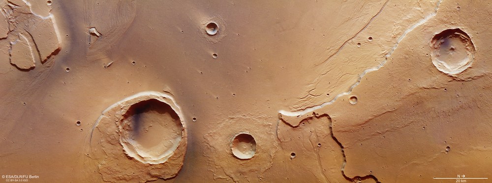
View of the estuary of Kasei Valles on Mars. Ancient megafloods carved out this region before finally flowing into Chryse Planitia. The Worcester impact crater – the largest crater visible in the image section with a diameter of around 25 kilometres – has resisted the erosive force of the flooding. In some places, its ejecta material has been worn away; downstream it has largely survived. As a result, a streamlined island was formed, which still denotes the flow direction (west to east). North is to the right in the image.
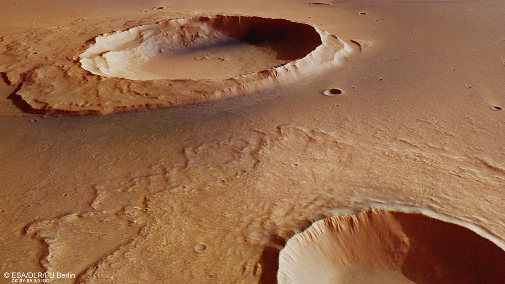
The Worcester impact crater (upper half of the image) has withstood the erosive force of the floods that formed Kasei Valles. A large part of its ejecta blanket has been eroded away, but downstream parts of it have remained almost complete. The rampart-like ejecta blanket of the crater in the foreground of the image indicates that water and ground ice were mobilised during this impact and combined with the ejecta material to form a kind of mudflow.
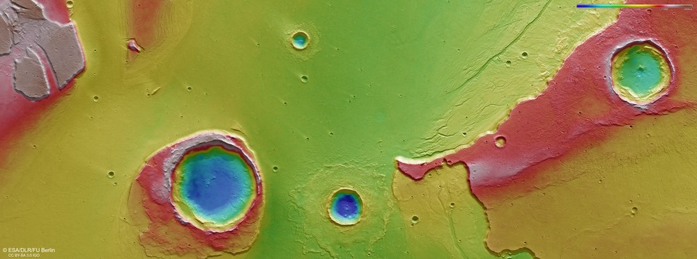
False colour topography of the Kasei Valles mouth region
Digital terrain models of the Martian surface can be created with an accuracy of up to 10 metres per pixel from the nadir channel, directed vertically onto the Martian surface, and the stereo channels of the HRSC camera. In this colour-coded image, the absolute elevations above a reference level, the areoid (derived from Ares, the Greek word for Mars), are shown. These elevation values can be read based on the colour scale at the top right of the image. The maximum difference in elevation values amounts to over 2000 metres.
The elevation differences illustrated in colour clearly show the residual ejecta blanket of Worcester Crater in the left half of the image. North is to the right in the image.
The Kasei Valles channel system is the result of multiple gigantic floods and not the continuous run-off of surface water.
Mapping the surface of Mars with the HRSC camera has enabled researchers to gain an insight into the overall topography of the planet and hence draw conclusions about its geological and climatic development.
The DLR-operated camera has now imaged 92 percent of the surface of Mars with a resolution of 10 to 30 metres per pixel.
Huge masses of water once flowed over the surface of Mars to form one of the largest outflow channels on the planet – Kasei Valles. These images, acquired by the High Resolution Stereo Camera (HRSC) show a section of the mouth of this outflow channel system, which lies in the transition region where the Chryse Planitia lowlands merge into the Martian highlands. The HRSC is operated by the German Aerospace Center (Deutsches Zentrum für Luft- und Raumfahrt; DLR) on board the ESA Mars Express spacecraft, which has been orbiting Mars since December 2003. The main objective of the camera is to map the topography of the entire planet in high resolution, in colour and in three dimensions.
Insights into geological and climatic development from HRSC images
"Our camera has now imaged over 92 percent of the surface of Mars with a spatial resolution of 10 to 30 metres," says Ralf Jaumann, DLR planetary researcher and Principal Investigator of the HRSC experiment. "The HRSC is continuously imaging the entire surface of the planet in three dimensions and in colour. This is rather unique for a space mission. The images enable us researchers to gain important knowledge of the geological and climatic history of the Red Planet."
The HRSC images show part of the mouth region of Kasei Valles in which numerous impact craters can be found. The wide channel system stretches for almost 2000 kilometres – significantly more than the Rhine – from its source region in Echus Chasma, north of the Valles Marineris rift valley on the Martian equator, to its sink in the Chryse Planitia impact basin. Numerous flooding events gave rise to this valley system approximately 3.6 to 3.4 billion years ago.
The outflow channels in the Kasei Valles region run straight over long distances. This leads to the conclusion that they were formed by individual megafloods, and not by a continuous run-off of surface water. In the latter case their courses would have taken a more meandrous form – as we see with large river valleys and streams on Earth. Presumably, enormous quantities of melted ground ice broke through to the surface, carving out these valleys as the water flowed. The reason for this sudden melting of the ice might be heat from volcanic centres, which heated up the rock and the ice stored in cavities in the surroundings of such hotspots.
Crater reflects the erosion of the floods
The Worcester impact crater (named after a city in New York State) – the largest of the craters visible in the image section with a diameter of around 25 kilometres – has largely resisted the erosive force of the megafloods in Kasei Valles. Firstly, with its 1.5-kilometre-high rim the crater forms a high morphological obstruction in the middle of the outflow valley; secondly, the rock in question was massively compacted by the impact and so resisted the erosive forces of the flooding better than the less compact material found in the surroundings. In some places, the ejecta material deposited around the crater during the impact has been worn away; elsewhere it has survived. As a result, a streamlined island facing downstream was formed that denotes the past course of the flow from west to east (in images 1, 3 and 4 from upper right to lower left). The terrace-shaped steps on the rim show how high the water levels were during the various flooding events. By comparison, the Ries Crater in southern Germany, which was formed 15 million years ago, has similar dimensions to Worcester Crater – which is 400 million years older and perhaps even more than one billion years old. Yet in ‘just’ 15 million years of existence, the rim of the Ries Crater has eroded heavily.
Next to Worcester crater, a smaller, unnamed impact crater (right in the image) shows the nature of the valley floor: its rampart-like ejecta reveal that the bottom of the floodplain is rich in water and ice. During the impact, the rock was mixed with water and vaporising ice, giving the ejecta mass much more of the characteristics of a liquid medium. By contrast, the radial ejecta blanket of the northernmost impact crater in the image, which is located on a plateau-shaped mesa (on the right edge of images 1, 3 and 4), indicates a dry, rocky subsoil. Terraces and small, dendritic channels at the foot of this eroded one-kilometre high mesa indicate varying flood magnitudes during numerous episodes of fluvial activity that shaped the landscape.
Image processing
The images were acquired by the HRSC (High Resolution Stereo Camera) during Mars Express Orbit 15,714 on 25 May 2016. The image resolution is 15 metres per pixel. The centre of the image is located at approximately 309 degrees East and 27 degrees North. The colour image was created from the nadir channel, orientated vertically onto the surface of Mars, and the colour channels of the HRSC. The perspective oblique view was computed from the HRSC stereo channels. The anaglyph image, which conveys a three-dimensional impression of the landscape when viewed with red-blue or red-green glasses, was derived from the nadir channel and one stereo channel. The aerial view, encoded in rainbow colours, is based on a digital terrain model (DTM) of the region from which the topography of the landscape can be derived. The reference unit for the HRSC-DTM is a globe. Staff specialising in planetology and remote sensing at the Free University of Berlin produced the views shown here. Systematic processing of the data was carried out at the DLR Institute of Planetary Research in Berlin-Adlershof.
The HRSC experiment
The High Resolution Stereo Camera was developed at the German Aerospace Center (Deutsches Zentrum für Luft- und Raumfahrt; DLR) and built in collaboration with partners in industry (EADS Astrium, Lewicki Microelectronic GmbH and Jena-Optronik GmbH). The science team, which is headed by principal investigator (PI) Ralf Jaumann, consists of over 40 co-investigators from 33 institutions and ten countries. The camera is operated by the DLR Institute of Planetary Research in Berlin-Adlershof. The images shown here were generated by the Institute of Geological Sciences at FU Berlin in conjunction with the DLR Institute of Planetary Research in Berlin.