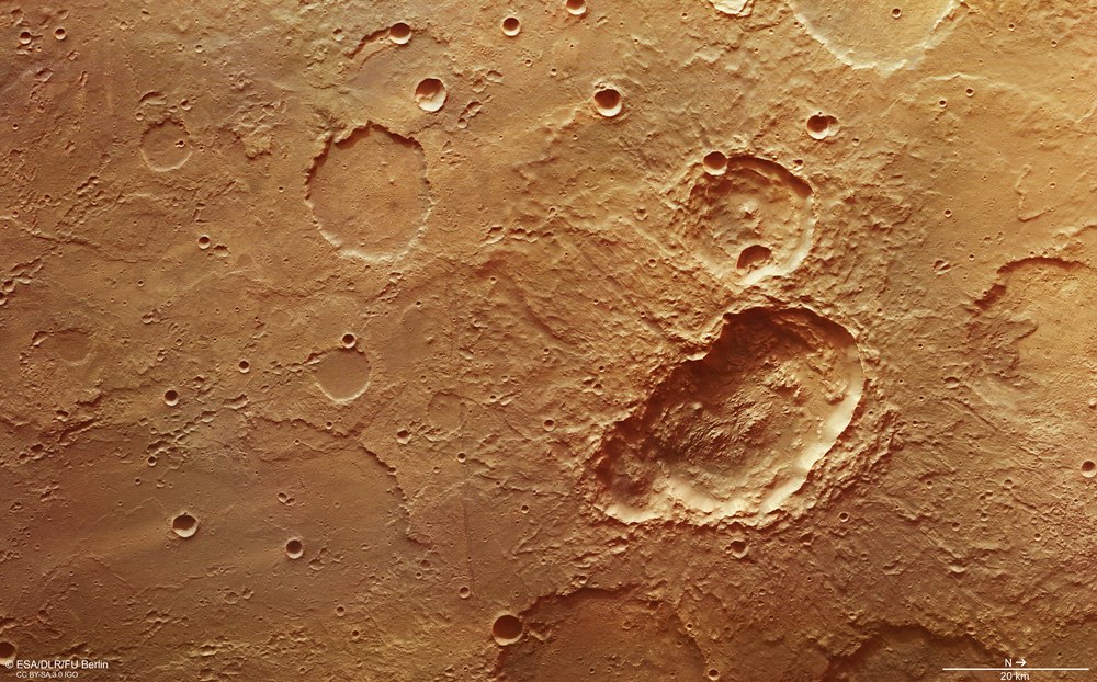
This depression, approximately 45 kilometres long and 24 kilometres wide, in the right half of the image, consists of three superposed impact craters. The triple crater was very likely formed by a single impactor that broke up into three parts prior to impact.
The triple crater is characterised by multi-layered ejecta deposits. To form this, the impact with the surface must have been at a low angle and ground ice must have existed in the subsoil that was liquefied or vapourised during the impact and combined with the local rock to form a muddy ejecta mass.
This crater is very probably a triple crater caused by a single asteroid that broke up into three parts prior to impact. There are layered deposits on the crater floor. These can also be found in numerous other impact craters in the vicinity, leading to the conclusion that liquid water existed in this region of the Martian surface for an extensive period of time.
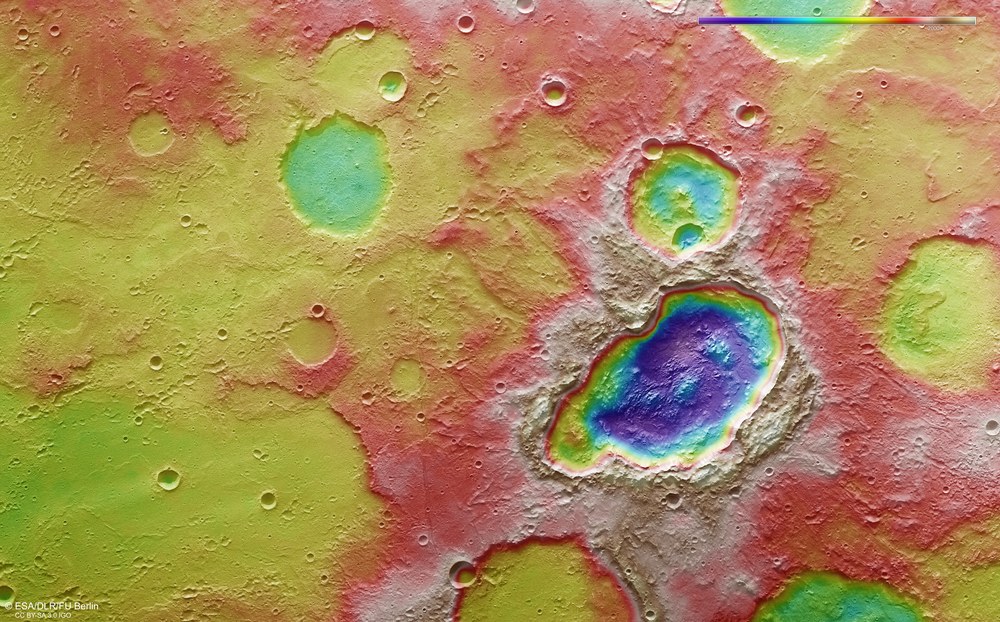
False colour representation of the topography of the triple crater in the Terra Sirenum region
Digital terrain models of the Martian surface are generated with an accuracy of up to 10 metres pixel from the nadir channel directed vertically onto the Martian surface and the stereo channels of the HRSC camera. In this colour-coded illustration, the absolute elevations above a reference level, the Areoid (derived from Ares, the Greek word for Mars), which corresponds to sea level on the Earth, are well depicted. These elevation values can be read based on the colour scale at the top right of the image. The coloured differences in altitude clearly show the depth of the triple crater in the right half of the image. The depth of almost 2000 metres indicates that this crater is significantly younger than its surroundings, which demonstrate a flat profile overall with depressions filled with sediments or lava flows. North is to the right in the image.
New images from the HRSC camera show three superposed impact craters, most likely caused by an asteroid that broke up into three pieces before impact.
Numerous sedimentary deposits in craters on Mars indicate that liquid water flowed on the surface for an extensive period.
Hydrological modelling computations for the Terra Sirenum region on Mars lead to the conclusion that there was once a high level of groundwater here.
Recent images acquired by the High Resolution Stereo Camera (HRSC) operated by the German Aerospace Center (Deutsches Zentrum für Luft- und Raumfahrt; DLR) on board the ESA Mars Express space probe show a triple crater in the Terra Sirenum region on Mars. Layered deposits are found at the bottom of the threefold impact crater. These are also found in many other impact craters in the surrounding area, suggesting that liquid water existed in this region of the Martian surface for an extensive period of time.
Multiple traces of water
Moreover, spectral signatures of clay minerals have been identified within impact craters and on intercrater plains in the northwest of Terra Sirenum, a very ancient highland region in the southwest of the Tharsis volcanic province. These discoveries were made using the OMEGA spectrometer on board the Mars Express mission and the CRISM spectrometer on board the NASA Mars Reconnaissance Orbiter. Both layered deposits and clay minerals are attributed to water-rock interaction.
There are signs of groundwater upwelling and evaporation in the Martian past. Hydrological modelling calculations of this region of Mars lead to the conclusion that there was once a high level of ground water here. The lower-lying depressions of impact craters were flooded by this, which may have led to the formation of lakes in the crater basins. The large diversity of mineral traces and deposits left by the evaporating surface water and that are visible today offer scientists the opportunity to investigate a more than 3.7-billion-year-old Martian landscape altered by water.
The old and new land
More impact craters are found in Terra Sirenum, as in the southern highlands generally, than in the northern lowlands. This means that the surface is older – even though several large, ancient impact craters are seen in the north as well, now covered by younger material. It is assumed that the age of the crust is comparable in both cases, but that later processes have replaced the ancient crust in the north with relatively young material. As a result, the rims of the underlying older craters indistinctly appear through this thin covering layer, because they have been covered almost entirely with sediments and have largely eroded away. This means that the surface in the north is younger.
Three in one stroke
At first glance the depression, approximately 45 kilometres long and 24 kilometres wide in the right (northern) half of the image, seems unspectacular. But in fact it is three superposed impact craters, presumably formed by a single asteroid that broke up into three fragments prior to impact, possibly because it was torn apart while entering the Martian atmosphere. The fact that the three craters are so close together suggests this. The other possibility – that the craters were formed as a result of three impact events at widely different times, is less likely as all three craters are in the same condition and so have presumably been exposed to erosion for the same amount of time.
View of the triple crater in Terra Sirenum, Credit: ESA/DLR/FU Berlin, CC BY-SA 3.0 IGO.
The triple crater is characterised by multi-layered ejecta deposits, where the overlapping of the ejecta material from the three craters has given rise to a type of butterfly shape. To form an ejecta blanket like this, the impact must have occurred at a low angle, and ground ice must have existed in the subsoil that was liquefied or vapourised during the impact and combined with the local rock to form a muddy ejecta mass. This led to a typical formation commonly found on Mars called rampart craters (see also the DLR image publication dated 5 June 2009). In the colour image (image 1) and colour coded elevation model (image 5), a so-called ‘forbidden zone’ can be seen at the upper right end of the triple crater where there is no ejecta material – the area is ‘forbidden’ because no material could be carried there in a low-angle impact. It indicates that the meteorite came from a northwesterly direction (north is to the right in these images).
Image processing
The images were acquired by the HRSC (High Resolution Stereo Camera) on 28 January 2017, during Mars Express Orbit 16,565. The image resolution is 22 metres per pixel. The centre of the image is located at approximately 198 degrees East and 27 degrees South. The colour image (image 1) was created from the nadir channel, orientated vertically onto the surface of Mars, and the colour channels of the HRSC. The perspective oblique view (image 2) was computed from the HRSC stereo channels. The anaglyph image (image 3), which conveys a three-dimensional impression of the landscape when viewed with red-blue or red-green glasses, was derived from the nadir channel and one stereo channel. The aerial view (image 5), encoded in rainbow colours, is based on a digital terrain model (DTM) of the region from which the topography of the landscape can be derived. The reference unit for the HRSC-DTM is a globe. Staff specialising in planetology and remote sensing at the Free University of Berlin produced the views shown here. Systematic processing of the data was carried out at the DLR Institute of Planetary Research in Berlin-Adlershof.
The HRSC experiment
The High Resolution Stereo Camera was developed at the German Aerospace Center (Deutsches Zentrum für Luft- und Raumfahrt; DLR) and built in collaboration with partners in industry (EADS Astrium, Lewicki Microelectronic GmbH and Jena-Optronik GmbH). The science team, which is headed by principal investigator (PI) Ralf Jaumann, consists of over 40 co-investigators from 33 institutions and ten countries. The camera is operated by the DLR Institute of Planetary Research in Berlin-Adlershof. The images shown here were generated by the Institute of Geological Sciences at FU Berlin in conjunction with the DLR Institute of Planetary Research in Berlin.