Your consent to the storage of data ('cookies') is required for the playback of this video on Quickchannel.com. You can view and change your current data storage settings at any time under privacy.
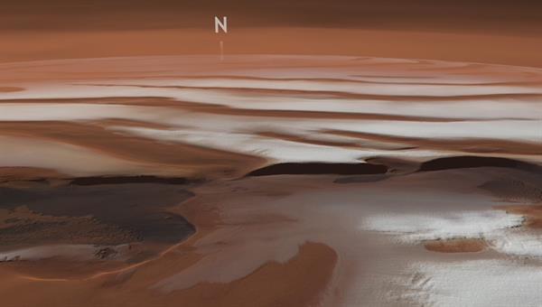
Animation: Flying over Mars' north polar cap
The video shows the permanent ice cap at the Martian North Pole and the up to 100-kilometre wide and 500-kilometre long valley Chasma Boreale. The north polar cap has a diameter of approximately 1100 kilometres and stands up to three kilometres above the surrounding landscape. It is also known as the summer ice cap and mainly consists of water ice.
The HRSC mosaic on which this video was based was compiled from 32 individual image strips (1154, 1177, 1219, 1291, 1394, 1745, 3663, 3681, 3685, 3695, 5483, 5775, 5784, 5796, 5808, 5810, 5818, 5824, 5827, 5838, 5853, 5864, 5867, 5900, 5904, 5963, 6007, 6229, 8042, 8080, 8153, 8160). The image position is located between 0 to 360 degrees east and around 78 to 90 degrees north. The colour mosaic was derived from the nadir channel perpendicular to the surface of Mars and the HRSC colour channels. The mosaic image was combined with topographic information from the Mars Orbiter Laser Altimeter (MOLA) experiment on board the NASA Mars Global Surveyor (MGS) spacecraft, resulting in a three-dimensional landscape. The global Mars view is based on the Viking MDIM 2.1 colour mosaic. Staff from the Planetary Sciences and Remote Sensing Division at Freie Universität Berlin used the image data to produce this animated overflight of the north polar cap. The systematic processing of the data was undertaken at the DLR Institute of Planetary Research in Berlin-Adlershof.
Image: 1/1, Credit:
ESA/DLR/FU Berlin (CC BY-SA 3.0 IGO)
The video shows the permanent ice cap at the Martian North Pole. It is also referred to as the summer ice cap and consists mainly of water ice.
Chasma Boreale is carved into the polar cap. Its formation is still unclear.
During the six month Martian winter, an additional layer of carbon dioxide forms over the permanent water ice cap.
Focus: Space, exploration
Mars' north polar cap looks like a gigantic spiral of ice and snow. Dark troughs, in which dust and deposits carried by the wind have accumulated, alternate with white, ice-clad hills. Chasma Boreale is a particularly striking trough that can be seen halfway through the film. This simulated overflight of the Martian North Pole reveals its permanent ice cap and Chasma Boreale. The images used for this video were acquired by the High Resolution Stereo Camera (HRSC), operated by the German Aerospace Center (Deutsches Zentrum für Luft- und Raumfahrt; DLR) on board the ESA Mars Express spacecraft.
The up to 100-kilometre wide and 500-kilometre long valley is carved into the north polar cap to a depth of two kilometres. Dark deposits are visible at the bottom of Chasma Boreale. These are mostly dunes of black sand that have been carried into the trough by the wind. The origin of Chasma Boreale is still unclear: the structure could have been formed by non-uniform accumulation of ice and dust, melting processes or wind erosion.
Atmospheric pressure fluctuations cause dust storms
Mars' permanent north polar cap, shown in the video, has a diameter of approximately 1100 kilometres and stands up to three kilometres above the surrounding landscape. It is also known as the summer ice cap and mainly consists of water ice. During the six-month long Martian winter, an additional layer of carbon dioxide ice forms over the permanent water ice cap, when the gaseous carbon dioxide in the Martian atmosphere condenses at temperatures below minus 120 degrees Celsius and covers the existing structures. This carbon dioxide winter ice cap is only approximately one metre thick. Since carbon dioxide is the principal component of the Martian atmosphere, however, atmospheric pressure drops significantly during the Martian winter, when up to a third of the atmospheric carbon dioxide is deposited. The ensuing seasonal atmospheric pressure fluctuations trigger major dust storms throughout the planet's northern hemisphere, offsetting the reductions in air pressure and spreading dust over the entire Martian surface.
The Martian winter is roughly twice as long as Earth's, as our neighbouring planet is further away from the Sun and therefore requires almost twice as long to complete an orbit. As on Earth, the reason for this is a rotational axis tilted by 25 degrees. As Mars' north polar cap is typically enveloped in thick carbon dioxide clouds in winter, it is difficult for the HRSC camera to acquire images at this time of year. Therefore, the images used in this video were mainly acquired during the summer.
Image processing
The HRSC mosaic on which this video was based was compiled from 32 individual image strips (1154, 1177, 1219, 1291, 1394, 1745, 3663, 3681, 3685, 3695, 5483, 5775, 5784, 5796, 5808, 5810, 5818, 5824, 5827, 5838, 5853, 5864, 5867, 5900, 5904, 5963, 6007, 6229, 8042, 8080, 8153, 8160). The image position is located between 0 to 360 degrees east and around 78 to 90 degrees north. The colour mosaic was derived from the nadir channel perpendicular to the surface of Mars and the HRSC colour channels. The mosaic image was combined with topographic information from the Mars Orbiter Laser Altimeter (MOLA) experiment on board the NASA Mars Global Surveyor (MGS) spacecraft, resulting in a three-dimensional landscape. The global Mars view is based on the Viking MDIM 2.1 colour mosaic. Staff from the Planetary Sciences and Remote Sensing Division at Freie Universität Berlin used the image data to produce this animated overflight of the north polar cap. The systematic processing of the data was undertaken at the DLR Institute of Planetary Research in Berlin-Adlershof.
The HRSC experiment
The High Resolution Stereo Camera was developed at the German Aerospace Center (Deutsches Zentrum für Luft- und Raumfahrt; DLR) and built in collaboration with partners in industry (EADS Astrium, Lewicki Microelectronic GmbH and Jena-Optronik GmbH). The science team, which is headed by principal investigator (PI) Ralf Jaumann, consists of over 40 co-investigators from 33 institutions and 10 countries. The camera is operated by the DLR Institute of Planetary Research in Berlin-Adlershof. The camera has been delivering images of the Red Planet since 2004.