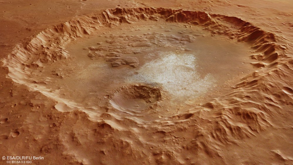
View of a crater with light-toned deposits and ‘chaotic’ areas in the Margaritifer Terra region
The high level of erosion of the crater suggests the old age of the approximately 70-kilometre crater. Landslides can be seen on the inner edge of the crater. The crater floor is no longer bowl-shaped but rather almost flat due to entering deposits. Most striking in this image is an extensive area of blocky, so-called ‘chaotic terrain’, as well as very bright areas where, presumably, the outcropping rock was laid bare and emerged without being covered in dust and sand.
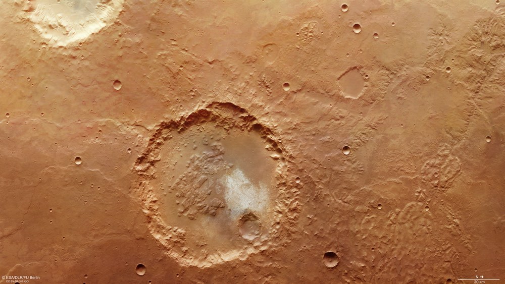
Crater with light-toned deposits in the southern highland Margaritifer Terra region
Located in the Margaritifer Terra region, this crater has a diameter of approximately 70 kilometres and a flat floor surrounded by a very eroded, almost encrusted crater rim, the inner wall of which is partly covered by the remains of earlier landslides. Terrace-like steps are still visible in the crater rim. The smooth crater floor in the north-western section transitions into blocky, ‘chaotic’ material in the western part. Some light-toned deposits are visible in the southeast of the crater, where presumably outcropping solid rock is exposed.
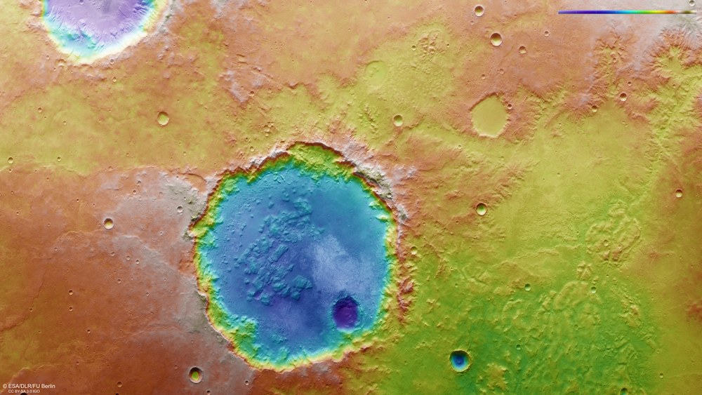
False colour representation of the topography of the crater in the Margaritifer Terra region
Digital terrain models of the Martian surface can be construed with an accuracy of up to 10 metres per pixel from the nadir channel, directed vertically onto the Martian surface, and the stereo channels of the HRSC camera. In these colour-coded representations, the absolute elevations above a reference level, the Areoid (derived from Ares, the Greek word for Mars), are well depicted. These elevation values can be read based on the colour scale at the top right of the image. North is to the right in the image. Despite the advanced erosion of the crater rim, the crater floor is located about 2000 metres below the surrounding plain of the southern highlands of Mars. A younger, smaller impact crater forms another 500-metre deep crater pit inside the unnamed, larger crater.
Impact crater in the Mars region Margaritifer Terra shows various geological features such as 'chaotic terrain' and light-toned deposits.
Chaotic areas indicate ice in the subsoil.
Focus: space exploration
'Chaos terrain' and unusually light-toned deposits inside an impact crater in the southern highlands of Mars can be seen in this set of images acquired by the High Resolution Stereo Camera (HRSC), operated by the German Aerospace Center (Deutsches Zentrum für Luft-und Raumfahrt; DLR) on board the ESA Mars Express spacecraft. Remnants of valley networks in the vicinity indicate the surface runoff of melt water in the Martian past.
Impact craters on Mars are very diverse; on the crater floors we find, for example, sediment deposits, landslide remains, dunes, and river deltas fanning out into the crater from the side, as well as ejecta material from other craters. Often, such geological landforms also occur in combination with one another and craters become more and more complex as their diameter increases. Small craters a few kilometres across have a simple, bowl-like profile, while craters approximately 100 kilometres across have terraces at their edges created within a few seconds of the crater’s formation and, at even larger diameters, even a central mountain can form due to the rebounding of the crater floor.
Fascinating crater in the southern highlands
Some of these phenomena can also be observed in the crater shown in these HRSC images. Located in the Margaritifer Terra region, this crater has a diameter of approximately 70 kilometres and a flat floor surrounded by a very eroded, almost encrusted crater rim, the inner wall of which is partly covered by the remains of earlier landslides. Terrace-like steps are still visible in the crater rim. The smooth crater floor in the north-western section transitions into blocky, 'chaotic' material in the western part. Some light-toned deposits are visible in the southeast of the crater. Thus far it has not been possible to determine what these bright, solid deposits consist of exactly.
Chaotic terrain points to ice in the subsoil
Numerous so-called chaotic terrain are found on Mars, and they are characterised by an irregular accumulation of rock blocks of various sizes and plateaus. "It is assumed that chaotic areas are formed when underground ice caves melt by volcanic heat and the water is suddenly released," says Ralf Jaumann, DLR planetary researcher and Principal Investigator of the HRSC experiment. "When the water drains away, the surface collapses over the newly created cavities and the landscape caves in. Chaotic terrain is left behind with the remaining plateaus, which are separated by a deeply carved valley network."
The chaotic terrain in the interior of the crater is characterised by plateaus, buttes and knobs. The same features are also found north of the crater (on the right in images 1, 3, 5), in an area called Erythraeum Chaos that is assumed to have contained a lake. Sediments on the floor of Erythraeum Chaos were possibly transported through the Paraná Valles network, which is located further east, and deposited there. The Paraná Valles, together with the Loire Valles, form one of the largest and best integrated valley systems on Mars (upper right corner of images 1, 3, 5). However, these river systems and lake existed more than 3.5 billion years ago.
"In general, such chaotic terrain and valley networks – many of which are still found today – are evidence of the transport, storage and release of water in the Martian past,' explains Jaumann.
Image processing
The image mosaic is composed of Mars Express HRSC (High Resolution Stereo Camera) orbit 16,648 from 22 February 2017 with a ground resolution of 15 metres per pixel and orbit 4090 from 13 March 2007 with a ground resolution of 17 metres per pixel. The images are centred at 346 degrees east and 23 degrees south. The colour image (1) was created using data from the nadir channel, the field of view which is aligned perpendicular to the surface of Mars, and the colour channels of the HRSC. The oblique perspective view (2) was generated using data from the HRSC stereo channels. The anaglyph image (3), which provides a three-dimensional view of the landscape when viewed using red-green or red-blue glasses, was derived from data acquired by the nadir channel and one stereo channel. The colour-coded topographic view (5) is based on a digital terrain model (DTM) of the region, from which the topography of the landscape can be derived. The reference body for the HRSC-DTM is a Mars sphere. Employees of the Department of Planetary Sciences and Remote Sensing at Freie Universität Berlin prepared the views shown here. The systematic processing of the data took place at the DLR Institute of Planetary Research in Berlin-Adlershof.
Map server
To download previously released raw images and DTMs of the region in GIS-ready formats, please use this link to the map server.
The HRSC experiment
The High Resolution Stereo Camera was developed at the German Aerospace Center (Deutsches Zentrum für Luft- und Raumfahrt; DLR) and built in collaboration with partners in industry (EADS Astrium, Lewicki Microelectronic GmbH and Jena-Optronik GmbH). The science team, which is headed by principal investigator (PI) Ralf Jaumann, consists of over 40 co-investigators from 33 institutions and 10 countries. The camera is operated by the DLR Institute of Planetary Research in Berlin-Adlershof. The camera has been delivering images of the Red Planet since 2004.