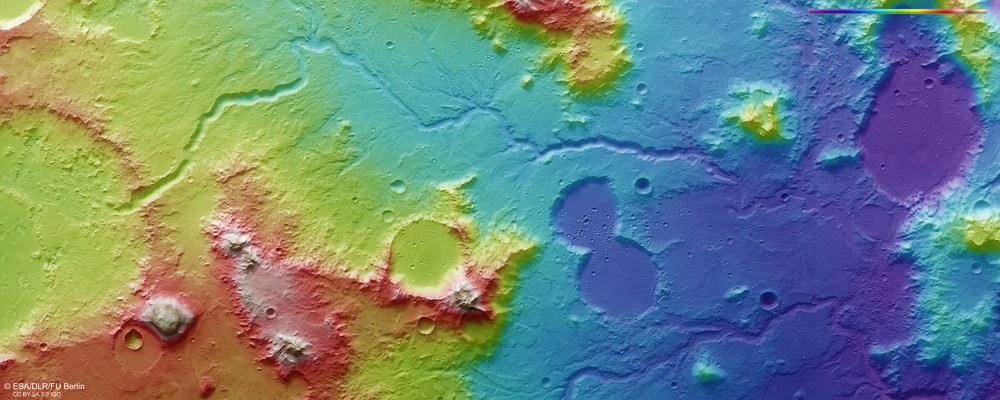
False-colour representation of the topography of the two river valleys in the Libya Montes region
Data acquired by the nadir channel of HRSC, which is aligned perpendicular to the surface of Mars, and the stereo channels can be used to generate Digital Terrain Models of the Martian surface with an accuracy of up to ten metres per pixel. These colour-coded representations clearly show the absolute heights above a reference surface, an Areoid (derived from the Greek word for Mars, Ares). Blue means low-lying; white indicates high altitude. North is on the right of the image. The water episodically flowing through the highlands has excavated valleys into the landscape with a depth of several hundred metres. There is a difference in altitude of about 3000 metres between the start of the valleys at the edge of an extremely weathered crater, which was presumably filled by a lake (on the left side of the image), and the plains around 150 kilometres further north on the right side of the image. This is around a thousand metres more than between the source of the River Inn near St. Moritz and the point where it flows into the Danube near Passau, but only about a third of that river’s length, so the average gradient of this river on Mars was three times as steep as a typical Alpine river.
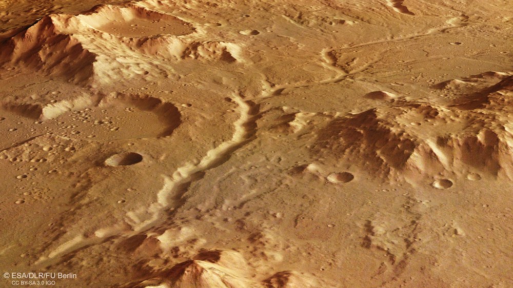
A view of the tributary valley, which is deeply carved and straighter than the main valley into which it flows. It was probably created by the run-off from a former crater lake in conjunction with ground water discharge.
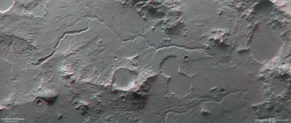
Anaglyph images can be generated from data acquired by the nadir channel of HRSC, which is aligned perpendicular to the surface of Mars, and one of the four stereo channels, which look forward and backwards along the spacecraft’s flight path. These provide a realistic three-dimensional view of the landscape when viewed using red and blue or red and green glasses. North is on the right of the image. The deeply carved drainage channels are clearly discernible, as is the levelling-off of some impact craters by solidified, low-viscosity lava.
Images of the Libya Montes region indicate that liquid water has shaped the surface.
Various clay minerals are also found in this region, which can only have been formed in the presence of water.
Focus: Space exploration
Libya Montes is a mountainous region on the Martian equator, south of the 1225-kilometre-wide impact basin that contains Isidis Planitia. The Libya Montes highland region is one of the oldest areas on Mars and has been significantly altered by volcanic processes and impact events, as well as by fluvial processes, that is, those associated with running water. The latest images acquired by the High Resolution Stereo Camera (HRSC), which is operated by the German Aerospace Center (Deutsches Zentrum für Luft- und Raumfahrt; DLR) and carried on board ESA's Mars Express spacecraft, identify a number of channels and dense valley networks in this region, which point to surface run-off, ground water discharge and intense erosion in the Martian past.
Not all rivers are alike
The southern valley section (on the left of Image 1) is a former tributary that flowed into the main river valley at the transition to the lowlands (from yellow to blue in Image 1). Hardly discernible here, the main river extended into the top (west) of the image. The tributary valley is deeply carved and rather straight. It was probably created by the run-off from a former crater lake (in the large crater on the far left of Image 1) in conjunction with ground water discharge. In contrast, the central valley section has a number of small feeder channels. Such an extensive river network suggests that the central section was probably fed by melting snow and ice formations in the mountains, rather than by surface water run-off.
The valley widens in the lower reaches of the former river and flows into a somewhat 'chaotic' area – together with a valley from the east – and finally into a flat impact crater (on the right of Image 1). Here, the crater floor is largely covered with lava, so that all traces of water activity have been overlaid. Like this one, most valleys in Libya Montes were formed by periodic surface water run-off and some were subsequently further shaped by ground water discharge (see also 'The Libya Montes highland region' dated 27 March 2006. This ground water was perhaps mobilised, for example, by volcanically-induced heat in the subsoil, which caused large amounts of underground ice to melt.
When did water flow here?
The evaluation of impact crater size-frequency distributions, a planetary research method aimed at estimating the age of a solid planetary surface, has shown that the valley was carved into the Martian surface around 3.6 billion years ago. This valley is therefore as old as most of the former river valleys in the Martian highland region. In particular, those with extensive river networks that were created by surface water run-off date from the times of the Martian Noachian and Hesperian periods. The linear river valleys, on the other hand, tend to be younger, because ground water discharge did not occur until later in Martian history. The lava deposits found in many of the region’s lower-lying areas can also be dated using the crater counting method. They are of varying ages (between 3.8 and 1.1 billion years old), suggesting that they are the outcome of various volcanic eruptions, or even that magma surged into the resulting crater as a result of an impact on the Martian surface.
Minerals as evidence of water
The mineralogy of the Libya Montes region is extremely diverse. There are various clay minerals, for example, which can only have been formed in the presence of water. They originate when volcanic rocks are chemically altered by water and heat, that is, weathered. Intense heat is thought to have been produced in this region, mainly by the impact that led to the creation of the Isidis Planitia basin. For tens of thousands of years after such huge impact events, hydrothermal processes often occur in the rocks in and around the crater, whereby hot water circulating at a depth of several kilometres releases chemical elements from the rocks. The minerals are therefore evidence for and are a consequence of these earlier weathering processes associated with water and heat. Clay minerals were formed from basaltic rock. These have already been discovered by the Martian orbiter, using its spectrometers.
Image processing
The images were acquired by the High Resolution Stereo Camera (HRSC) on 21 February 2017 during Orbit 16647 of the Mars Express spacecraft. The image resolution is 15 metres per pixel. The image centre is located at approximately 90 degrees east and one degree north. The colour plan view was created from data acquired by the nadir channel, which is oriented perpendicular to the surface of Mars and the HRSC colour channels; the perspective view was computed from data acquired by the HRSC stereo channels. The anaglyph image, which provides a three-dimensional impression of the landscape when viewed through red and blue or red and green glasses, was derived from data acquired by the nadir channel and one stereo channel. The colour-coded overview is based on a Digital Terrain Model (DTM) of the region, from which the topography of the landscape can be derived. The reference body for the HRSC-DTM is a Mars sphere. Staff from the Planetary Sciences and Remote Sensing Department at Freie Universität Berlin produced the images shown here. Systematic processing of the data was undertaken at the DLR Institute of Planetary Research in Berlin-Adlershof.
The HRSC experiment
The High Resolution Stereo Camera was developed at the German Aerospace Center (Deutsches Zentrum für Luft- und Raumfahrt; DLR) and built in collaboration with partners in industry (EADS Astrium, Lewicki Microelectronic GmbH and Jena-Optronik GmbH). The science team, which is headed by principal investigator (PI) Ralf Jaumann, consists of over 40 co-investigators from 33 institutions and 10 countries. The camera is operated by the DLR Institute of Planetary Research in Berlin-Adlershof. The camera has been delivering images of the Red Planet since 2004.