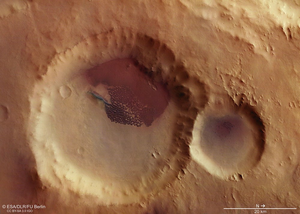
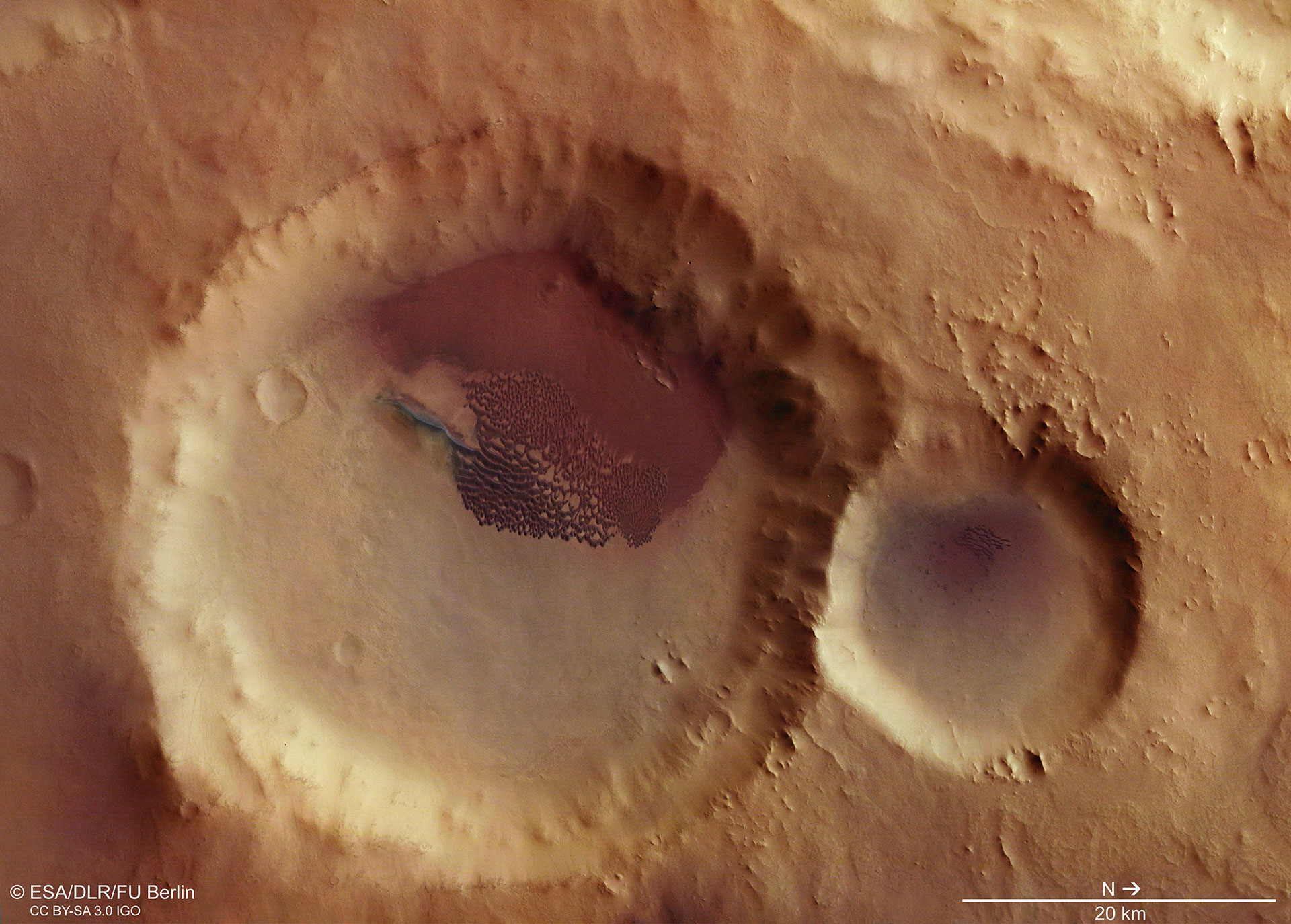
Crater with dune field close to the Aonia Tholus volcano
Operated by DLR on board Mars Express, the HRSC takes simultaneous images in high resolution, 3D and with four colour filters in the visible light for the colours blue, green and red, as well as in near-infrared wavelengths. This highly contrasted, true-colour image created by the nadir channel, which is directed vertically at the surface of Mars, and the colour channels clearly shows the material differences in the otherwise somewhat monochrome surface of Mars. The dark dune field inside the 48-kilometre impact crater (on the left) is particularly striking. The crater is not far from the volcano Aonia Tholus. Earlier volcanic activity on Mars produced vast quantities of fine-grained ash, which was covered by other rocky materials over time. Impact craters exposed these concealed layers – which are therefore seen as the probable source of the dark dunes. North is on the right of the image.
View into a crater with dark dunes in the Aonia Terra region
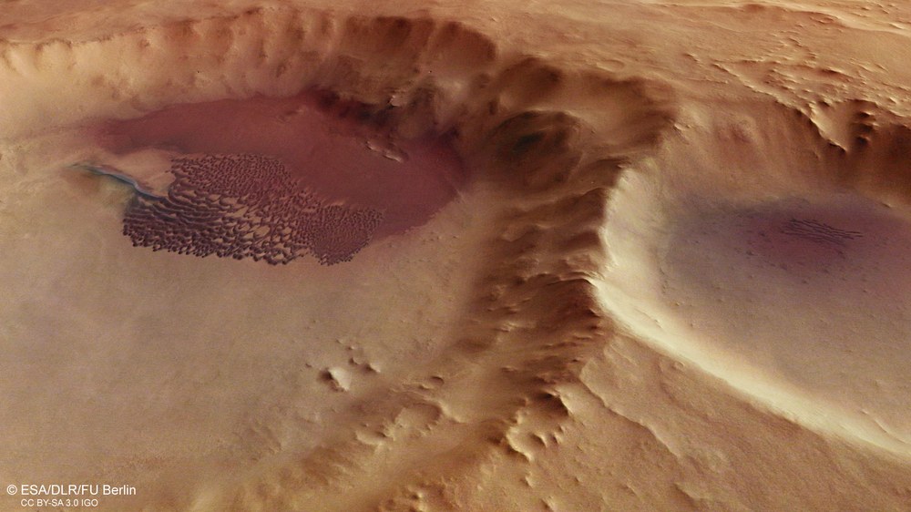
The images were taken by the HRSC (High Resolution Stereo Camera) on 16 May 2017 during Mars Express orbit number 16934. The image resolution is 13 metres per pixel. An expansive field of dark dunes is located inside the large crater on the left of the image. The shape of the field is indicative of a prevailing wind direction from the south-east (approximately bottom left). Material from previous volcanic activity gives the dunes their typical dark colour. Just over a dozen barchans or crescent-shaped dunes are found in the smaller crater directly adjacent.
Your consent to the storage of data ('cookies') is required for the playback of this video on Quickchannel.com. You can view and change your current data storage settings at any time under privacy.
Webcast - The weather and climate on Mars
In this interview, Daniela Tirsch, a planetary geologist at the DLR Institute of Planetary Research, explains how wind and weather continue to leave their mark on the surface of Mars today.
Image: 6/6, Credit:
DLR (CC-BY 3.0)
By analysing the form and structure of the dunes, there is a lot to learn about the wind as a force of design on our neighbouring planet.
The composition of these dark dunes strongly resembles that of volcanic ash encountered on Earth.
Focus: Space exploration
Two impact craters with expanses of dunes, located deep in the southern highlands of the Red Planet, can be seen in these images acquired by the High Resolution Stereo Camera (HRSC) on board the ESA Mars Express spacecraft. The HRSC was developed and is operated by the German Aerospace Center (Deutsches Zentrum für Luft- und Raumfahrt; DLR).
There are no sand dunes without wind. This simple truth applies to dunes formed on Earth as much as it does to those on Mars, or even Saturn’s icy moon Titan. Dunes are therefore typical indicators of wind activity. We can learn a lot about wind as a force of design on Mars, simply by analysing the form and structure of the dunes.
The dune field in the larger of the two impact craters shown in these images consists of many smaller and a few larger crescent-shaped dunes (knowns as barchans). Wherever there was sufficient sand, the dunes have grown together, producing parallel, somewhat wavy rows arranged perpendicularly to the prevailing wind, known as a barchanoid dune ridge. These dunes are also found in the smaller of the two craters: barchans and barchanoid dunes are the most common dune type found on Mars, in contrast to Earth, where the most common type are linear/longitudinal dunes.
Whence does the wind blow? – Just ask the dunes
The type of dune that emerges depends primarily on the number of wind directions and the quantity of sand. For instance, the crescent-shaped dunes often encountered on Mars are produced by a paucity of sand, coupled with a uniform wind direction. A single, longitudinal barchanoid ridge, extending outside the main field, is located on the southern reaches of the dune field, inside the large, almost 50-kilometre diameter crater (on the left in the images). Stretching several kilometres, the unusual structure resembles that of a seif dune, which may have been produced by local prevailing winds from two directions caused by the particular topography on the edges of the dune field. The sand was deposited to form an evenly distributed stratum in the western part of the crater (at the top in the images).
From the orientation of the individual dunes and the location of the dune field relative to the centre of the crater, it is reasonable to infer that these topographical structures were formed by winds from the south-east. North is to the right in the aerial views. The dune fields in the adjacent impact craters Ross and Lamont (on the left in the overview map) and a few smaller craters in the area also indicate a wind direction predominantly from the south east. Nevertheless, the local topography has produced a different wind direction – and therefore alternate dune shapes – in certain areas.
Dark dunes – Indications of volcanic activity
Depressions such as impact craters tend to act as ‘sediment traps’ – the wind blows the sandy material into them, where it accumulates at the base. But there are few indications that sand was indeed blown into the craters on Mars. It is far more common to see large vanes extending from the dune fields up to the craters as indication of material being carried away. Scientists have discovered indications that the sand in a few of the crater walls originates from dark sediment layers located directly on the crater wall. The Rabe Crater is an example of this, where the scientists have observed almost black sand trickling down the walls and accumulating to form dunes directly at the base. These dark, 'outcropping' layers by the crater walls are often covered by other material (regolith) and are only exposed in a few cases, for instance when the Sun warms up the frozen soil. These black sands are almost certainly of volcanic origin, as they consist of minerals that could only have been transported to the martian surface by volcanism. Moreover, their composition strongly resembles that of volcanic ash encountered on Earth.
Forty-eight kilometres wide, the impact crater is not far from the volcano Aonia Tholus. Earlier volcanic activity on Mars produced immense quantities of fine-grained ash that formed immense layers and was then concealed beneath other rocky material. Impact craters cut through these dark layers, making them the probable source of the dark dunes. Five large volcanic provinces – including the vast Tharsis region – and countless small, scattered volcanoes have produced a virtually global distribution of the ash layers, meaning that this kind of dark dune is found almost everywhere on Mars.
Image processing
The images were acquired by the HRSC (High Resolution Stereo Camera) on 16 May 2017 during Mars Express Orbit 16934. The ground resolution is approximately 13 metres per pixel and the images are centered at 248 degrees East and 59 degrees South. The colour image (1) was created using data from the nadir channel, the field of view which is aligned perpendicular to the surface of Mars, and the colour channels of the HRSC. The oblique perspective view (2) was generated using data from the HRSC stereo channels. The anaglyph (3), which provides a three-dimensional view of the landscape when viewed using red-green or red-blue glasses, was derived from data acquired by the nadir channel and one stereo channel. The colour-coded topographic view (5) is based on a digital terrain model (DTM) of the region, from which the topography of the landscape can be derived. The reference body for the HRSC-DTM is a Mars equipotential surface (Areoid). The systematic processing of the HRSC image data was carried out at the DLR Institute of Planetary Research and the views shown here were created by the Planetary Sciences and Remote Sensing group at Freie Universität Berlin.
The HRSC experiment
The High Resolution Stereo Camera was developed at the German Aerospace Center (Deutsches Zentrum für Luft- und Raumfahrt; DLR) and built in collaboration with partners in industry (EADS Astrium, Lewicki Microelectronic GmbH and Jena-Optronik GmbH). The science team, which is headed by principal investigator (PI) Ralf Jaumann, consists of over 40 co-investigators from 33 institutions and 10 countries. The camera is operated by the DLR Institute of Planetary Research in Berlin-Adlershof. The camera has been delivering images of the Red Planet since 2004.
