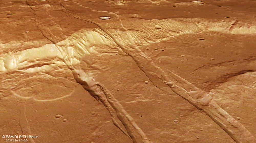
Oblique view of a ridge, three graben and a landslide
The digital topographical models derived from HRSC stereo image data make it possible to compute perspective views of the Martian landscape. These can often provide a much better visual understanding of geological phenomena and processes than a top view. This image is equivalent to a view from an aircraft that is tilted at an angle, looking down on a ridge some 2000 metres tall and intersected almost vertically by three graben structures: two very obvious graben to the right of the picture, and a smaller, less obvious graben to their left that does not run all the way through the image. Part of this smaller graben is also covered by an enormous fan-shaped area of rock debris emanating from a very obvious escarpment from which a massive landslip has occurred. The central graben also shows a striking furrow-like depression – presumably here the bottom of the graben has slumped into hollows that had formed beneath it.
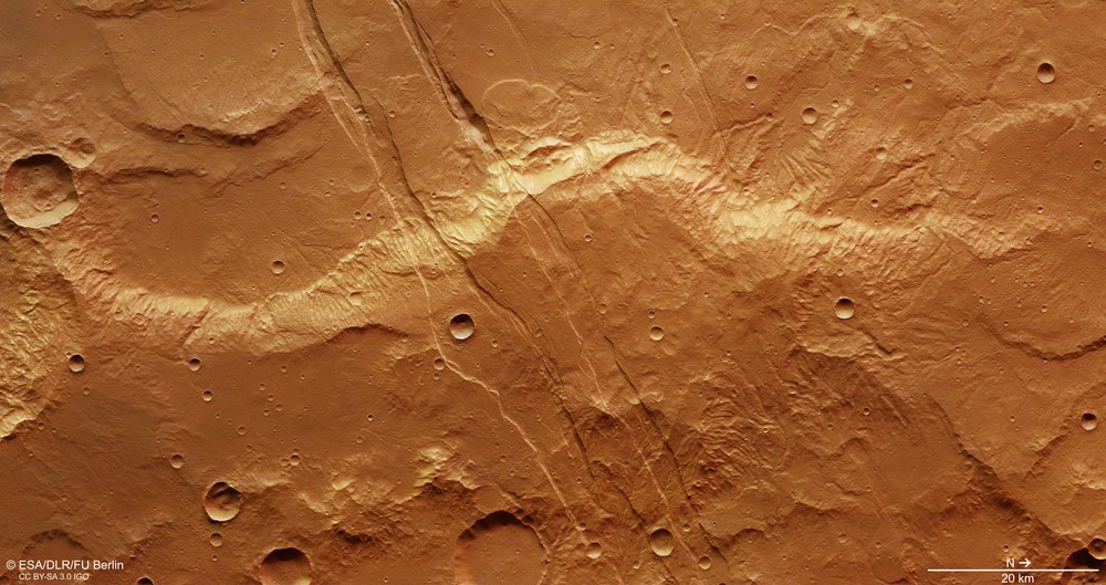
The more or less parallel fault lines in Sirenum Fossae clearly show the direction in which tensions in the Martian crust run – geophysicists refer to this as ‘tectonic stress’. North is to the right, and the grabens run from northeast to southwest. The forces that stretched the crust, ultimately resulting in its fracturing, ran perpendicular to this – that is, in a south-easterly to north-westerly direction. In this process, the existing three- to four-billion-year-old plateau was 'dissected' in a straight line. The image also shows the result of more recent geological processes. For example, asteroid impacts have left craters with barely weathered rims; huge landslides have occurred along the 2000-metre-high ridge in the upper third of the image, forming tongue-shaped deposits; and small gullies may possibly be the result of erosion by water running down the slopes.
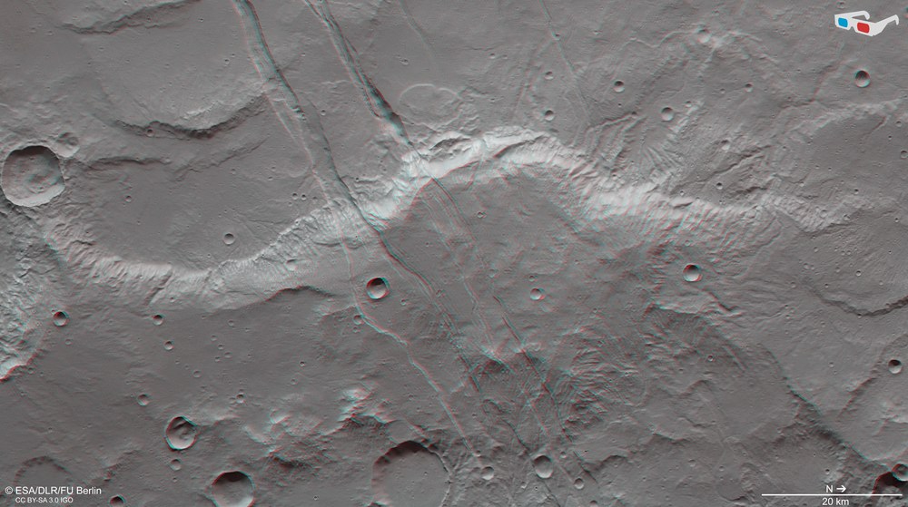
So-called anaglyph images can be produced from the nadir channel (oriented perpendicular to the surface of Mars) of the HRSC camera system operated by the DLR on board the Mars Express spacecraft and one of the four oblique-view stereo channels. When viewed with red-blue or red-green glasses, these images give a realistic, three-dimensional view of the landscape. North is to the right in the image.
Using anaglyph glasses, the topographical proportions in the region can be seen very clearly. A ridge approximately 2000 metres high crosses the image in a north-south direction. It is intersected by several parallel graben. Between each pair of fault lines, the surface has subsided by several hundred metres. Other features that stand out in very marked relief when viewed with 3D glasses include a number of young craters with strikingly sharp rims (which indicate that they are young), some landslides, and some small grooves along the ridge, likewise caused by erosion, possibly even by water runoff.
The Sirenum Fossae graben system spans thousands of kilometres across the Martian surface and was formed through tectonic processes.
Its formation is probably related to magmatic activity.
Such structures are also frequently found on Earth in volcanic rift zones, such as in Iceland.
Focus: Space, planetary research
These images, acquired by the High Resolution Stereo Camera (HRSC) operated by the German Aerospace Center (Deutsches Zentrum für Luft- und Raumfahrt; DLR) on board the ESA Mars Express spacecraft, show a region of Mars strongly shaped by volcanic activity. Traces of this activity include the striking parallel grabens that cross the region – the Sirenum Fossae.
Sirenum Fossae is a graben system formed by tectonics – that is to say movements resulting from tension in the Martian crust. They are up to nine kilometres wide, with depths ranging from a few hundred metres to one and a half kilometres, and extend for thousands of kilometres across the surface of Mars. The expansion of the rigid Martian crust resulted in linear rifts and the subsidence of heavy blocks of crust between two fault lines in the ductile subsurface.
It is generally assumed that the proliferation of such grabens on Mars is related to magmatic activity and with dikes. These are steep corridors within the rock along which magma from the interior of Mars can propagate upward. When such dikes reach the surface, volcanic eruptions occur along these fissures and cracks, with an outpour of lava. However, if they remain ‘stuck’ underground, they exert pressure on the surface from below – the strength of this pressure being dependent on the volume of the accumulated mass – which in turn results in tension and causes the surface to fracture.
Large concentrations of such dikes, known as dike swarms, are very common in volcanic rift zones (large regional stretch zones) on Earth, for example in Iceland, where they can be observed, together with surface fractures and graben sets, in the Krafla fissure swarm.
The Tharsis volcanic province – cause of the grabens?
It is not yet clear whether Sirenum Fossae was formed by local or regional magmatic events. In case of the latter, they would be part of a huge radial system of dikes whose centre lies further east in the Tharsis region. Tharsis is the largest volcanic region on Mars. It spans an area the size of Europe, and rises like a shield more than four kilometres above the Martian surface. Some of the largest volcanoes in the Solar System can be found here, including Olympus Mons (rising 22 kilometres above the reference level of Mars), and the three Tharsis volcanoes Ascraeus (15 kilometres), Pavonis (eight kilometres) and Arsia (11 kilometres).
The Sirenum Fossae are part of a radial fracture pattern around the Arsia Mons volcano in Tharsis, some 1800 kilometres northeast of the region that can be seen in these images. The deformations run right through the area in the images, across all types of terrain. This shows that the deformations are younger than the mountain ridges in the bottom (to the east) half of the image, and also younger than the plateaus in the upper (to the west) half of the image. A small number of impact craters in the graben formed at a later date, however, and if they are found in statistically sufficient numbers along the rest of the graben system, they may be helpful in determining the age of the tectonic structure.
Image processing
The images were acquired by the HRSC (High Resolution Stereo Camera) on 5 March 2017 during Mars Express Orbit 16688. The image resolution is 14 metres per picture element (pixel). The centre of the image is located at approximately 215 degrees east and 28 degrees south. The colour aerial view (image 2) was created from the nadir channel, oriented perpendicular to the surface of Mars, and the colour channels of the HRSC. The perspective angle view (image 1) was computed from the HRSC stereo channels. The anaglyph image (image 5), which conveys a three-dimensional impression of the landscape when viewed with red-blue or red-green glasses, was derived from the nadir channel and one stereo channel. The aerial view (image 4), encoded in rainbow colours, is based on a digital terrain model (DTM) of the region from which the topography of the landscape can be derived. The reference unit for the HRSC-DTM is an equipotential surface of Mars (areoid). Systematic processing of the camera data was carried out at the DLR Institute of Planetary Research. From this data, staff specialising in planetology and remote sensing at the Free University of Berlin produced the views shown here.
The HRSC experiment on board Mars Express
The High Resolution Stereo Camera was developed at the German Aerospace Center (Deutsches Zentrum für Luft- und Raumfahrt; DLR) and built in collaboration with partners in industry (EADS Astrium, Lewicki Microelectronic GmbH and Jena-Optronik GmbH). The science team, which is headed by principal investigator (PI) Ralf Jaumann, consists of over 40 co-investigators from 33 institutions and 10 countries. The camera is operated by the DLR Institute of Planetary Research in Berlin-Adlershof. The camera has been delivering images of the Red Planet since 2004.