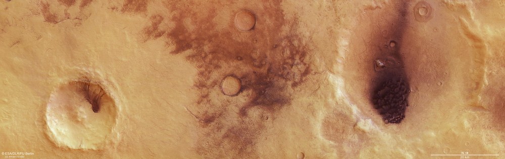
Chalcoporos Rupes shown in contrast-enhanced colour
The depicted region reveals very strong light and dark contrasts. Against the Martian landscape, with its well-known ochre colouring, larger dark areas can be seen in two craters that have been almost levelled by erosion, as well as a pattern of fine dark lines spread over an area of over 2000 square kilometres. The large dark area in the northern crater (on the right-hand side of the image), around 35 kilometres across, is a dune field of dark sands blown by the wind. A small dune field can be seen on the floor of the southern crater (on the left-hand side of the picture), this time consisting of material from the exposed dark layers towards the top of the crater wall. The dark lines in the centre of the image are aeolian phenomena, that is, they are caused by wind. These are the tracks of small whirlwinds, or ‘dust devils’, which are the result of atmospheric turbulence. When a dust devil travels across the Martian surface, it lifts a thin layer of light-coloured sand from the ground, exposing the underlying darker material. The fine dark tracks mark the paths taken by dust devils.
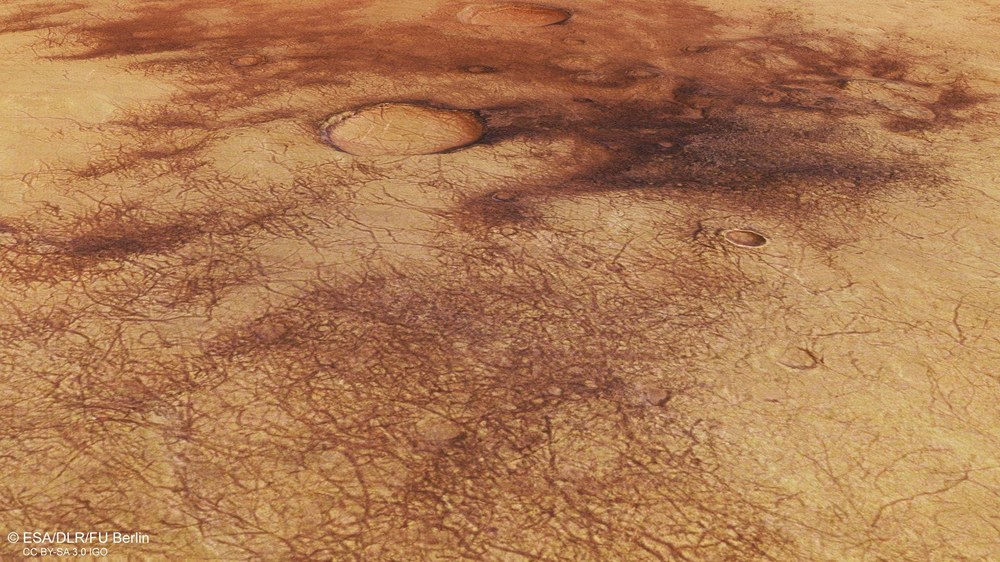
Perspective view of dust devil tracks in Chalcoporos Rupes
This pattern of dark, narrow, thread-like stripes was created by small whirlwinds, or dust devils, which are caused by atmospheric turbulence. When a dust devil travels across the Martian surface, it lifts a thin layer of light-coloured sand from the ground, exposing the darker material beneath. The tracks mark the paths taken by the dust devils. The trails left by dust devils on the Martian surface can be up to several hundred metres wide and several kilometres long. Their lifespan is relatively short, as they tend to be covered over again by light-coloured sand, especially after dust storms, so that they disappear within a matter of days or months. The image shows an area approximately 50 kilometres across.
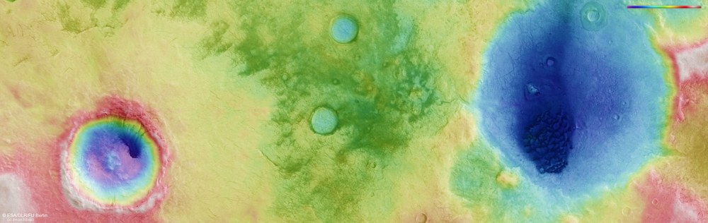
The image strips captured from different angles by the High Resolution Stereo Camera (HRSC) on board Mars Express were used to generate digital terrain models of the Martian surface. They contain height information for each recorded pixel. The reference level to which the altitude readings refer is an imaginary surface that represents the same gravitational pull as that at sea level on Earth. Known as an equipotential surface, this is shaped like a biaxial ellipsoid and is known as an Areoid, a name derived from Ares, the Greek name for Mars. In this image, north is to the right. The colour coding of the digital terrain model (top right) indicates the elevation differences effectively: the topographical profile of the region covers roughly 1200 metres of elevation and shows that the Martian highlands in this area form an extensive plateau without any major differences in height, apart from the depressions of two large craters, whose entire profile has already been significantly levelled by erosion. On the upper (western) rim of the larger crater is another smaller crater whose circular ejecta blanket stands out strikingly against the topographical image map. Known as a rampart crater, this is typical of certain regions on Mars where underground ice is (or once was) present. An asteroid impact creates this distinctive ejecta blanket, which is formed by rock debris mixed with water. .
The Chalcoporos Rupes region is located in the southern Martian highlands approximately 1000 kilometres west of the Hellas impact basin.
The region is characterised by a heavy dust blanket and the activity of Martian winds. Here, narrow, dark lines that have been created by 'dust devils' – small whirlwinds – are striking.
From these, the wind directions in this region can be derived.
On Earth, dust devils are typically observed during summer in dry and desert landscapes, for example in the southwestern USA, Africa, Australia and China.
Focus: Spaceflight, planetary research, Mars
New images acquired by the High Resolution Stereo Camera (HRSC) operated by the German Aerospace Center (Deutsches Zentrum für Luft- und Raumfahrt; DLR) on board the European Space Agency's (ESA) Mars Express spacecraft in early 2019 show a region in the southern hemisphere of Mars that is defined by a thick blanket of dust and the activity of Martian winds. These aeolian forces – named after Aeolus, the god of the winds in Greek mythology – have left a striking pattern on the Martian surface, along with dark dunes. Particularly prominent are the numerous narrow dark lines left by dust devils, or small whirlwinds, on the ground. These allow scientists to deduce the direction of winds in this region.
Mars Express, the first planetary mission undertaken by ESA, has been orbiting Earth's neighbouring planet for more than 15 years and will soon have circled Mars 20,000 times. HRSC has imaged a section of the Martian surface on roughly every third to fourth orbit of Mars. Systematic processing of the camera data is carried out at the DLR Institute of Planetary Research in Berlin-Adlershof. From this data, staff specialising in planetology and remote sensing at the Freie Universität Berlin produced the views shown here. The Chalcoporos Rupes region is located in the southern Martian highlands, around 1000 kilometres to the west of the Hellas impact basin and a few hundred kilometres southwest of Neukum Crater, which was named last year in honour of the 'father' of the HRSC, Gerhard Neukum, who worked at DLR and the Freie Universität Berlin.
Small whirlwinds act like vacuum cleaners to expose the subsoil
The dark, narrow, thread-like stripes that can be seen in the images are the traces of small whirlwinds – known as dust devils – which are caused by atmospheric turbulence. Dust devils on Mars form in a similar way to their counterparts on Earth – as the Martian soil is warmed by sunlight during the day, the heated air rises, creating an updraught. Under certain conditions, this updraught then begins to rotate, causing a vertical vortex. Differences in atmospheric pressure create a suction effect, lifting any loose material from the surface. On Mars, this loose material is dust; on Earth it may also come in the form of sand or snow. When a dust devil moves across the Martian surface, it lifts a thin layer of light-coloured sand from the ground, exposing the darker underlying material. These narrow dark tracks mark the paths taken by dust devils.
The trails left by dust devils on the Martian surface can be up to several hundred metres wide and several kilometres long. They tend to form in the afternoon on warm spring and summer days, when the surface is illuminated by sunlight for a longer time, and thus heats up more. Nevertheless, dust devils have also been observed during the winter months. Dust devil tracks may run straight or follow curved or winding paths, as well as intersecting or overlapping with one another. Their lifespan is relatively short, as they tend to be covered over again by light-coloured sand that is whipped up by dust storms, so that they disappear within a matter of days or months.
Dust devil traces can be found almost everywhere on Mars. They are particularly well documented on the plains of Amazonis Planitia and Argyre Planitia, as well as on Hellas Planitia, the lowland plain in Hellas, the largest impact basin on Mars. However, they can also be seen in the Proctor and Russell impact craters near the area shown here, as well as in many other regions of Mars. NASA's Mars rovers have observed dust devils in action by chance, and they have even more frequently been captured in satellite images of the Martian surface. If such images are taken in quick succession, the speed of the dust devils can be determined and their movement replicated in short animations. A particularly striking example is the series of 21 images acquired by the Mars exploration rover Spirit on 15 May 2005 near its landing site in Gusev Crater, showing a dust devil one kilometre away over a period of almost 10 minutes, which were compiled by NASA to create a 'flip book'.
Measurements showed that this dust devil was travelling at a speed of approximately 17 kilometres per hour, and was 35 metres in diameter. According to measurements taken from orbit, dust devils on Mars move much more rapidly than those on Earth. Although first-hand sightings of dust devils are far more common on our planet, they leave few recorded traces. They are typically observed in summer in dry desert landscapes, such as in the southwestern United States, Africa, Australia and China.
Large temperature differences due to intense warming during the day mean that the dust devils on Mars can be much bigger than those on Earth. On Mars, they can reach a height of eight kilometres, effectively carrying dust into the Martian atmosphere. Estimates suggest that overall, dust devils on Mars can lift as much material as a global dust storm, thus contributing significantly to an increased amount of dust in the atmosphere.
The dark deposits in the two impact craters shown in the north and south in Image 1 (right and left) are dune fields. On Mars, these mainly consist of old volcanic ash – hence their dark hue. In this contrast-enhanced image they have a slightly blue tinge, but in reality they range from black to grey. Dark dune fields are abundant on Mars and are often located on the floor of impact craters. Contrary to initial assumptions, the dust is not swept into the craters, becoming trapped there, but rather forms within the crater itself. It often originates from dark layers of buried volcanic ash that have been re-exposed by the impact crater. One good example is the southern (left-hand) crater in Image 1, where the crater wall reveals dark gullies. The dark dust trickles out of a layer in the crater wall and is transported down the gullies and into the interior of the crater, where the wind finally shapes it into dunes.
The colour of the dunes is very similar to the colour of the Martian soil exposed by the tracks of the dust devils. This is because almost the entire Martian surface consists of volcanic rock, which has a high iron and magnesium content and is very dark – just like the volcanic ash in the dunes. The lighter dust that covers large swathes of the Martian surface ranges from ochre to reddish in colour, as it has 'rusted' through the process of oxidation, whereby the once-dark iron in the dust reacted with the scarce oxygen in the Martian atmosphere to form iron oxide, turning it a shade of red. Most dunes on Mars are not covered in dust, as their material is constantly shifting, affording no opportunity for a layer of dust to settle.
Image processing The High Resolution Stereo Camera (HRSC) acquired the data from which these images were created on 3 January 2019 during Mars Express orbit 18,983. The image resolution is 13 metres per pixel. The centre of the imaged area is at approximately 23 degrees east and 53 degrees south. The colour image was generated using data from the HRSC nadir channel, the field of view of which is directed perpendicular to the surface of Mars, and the colour channels. The perspective oblique view was computed from terrain model data and data from the nadir and colour channels of HRSC. The anaglyph image, which gives a three-dimensional impression of the landscape when viewed with red-blue or red-green glasses, was derived from data acquired by the nadir channel and the stereo channels. The colour-coded topographic image is derived from a digital terrain model (DTM) of the region from which the topography of the landscape can be computed. The reference body for the HRSC DTM is a Martian equipotential surface (Areoid).
HRSC on Mars Express The High Resolution Stereo Camera was developed by the German Aerospace Center (Deutsches Zentrum für Luft- und Raumfahrt; DLR) and built in collaboration with partners in industry (EADS Astrium, Lewicki Microelectronic GmbH and Jena-Optronik GmbH). The science team, which is headed by Principal Investigator (PI) Ralf Jaumann, consists of 51 co-investigators from 35 institutions in 11 countries. The camera is operated by the DLR Institute of Planetary Research in Berlin-Adlershof.
