Aurorae Chaos – terrain collapse due to water run-off?
June 27, 2019
Aurorae Chaos – terrain collapse due to water run-off?
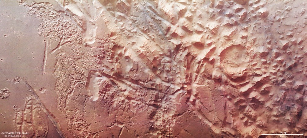
Aurorae Chaos in colour
The transition zone between the plateaus of the Martian highlands in Margaritifer Terra and the chaotic areas in the Aurorae Chaos depression have been shaped by radical geological processes. Water stored in cavities beneath the surface as underground ice thawed due to heating and escaped onto the surface. The resulting cavities collapsed, and much of the rock debris was carried away by the water as a sediment load. In the surrounding area, individual table mountains and buttes remained as remnants of the original plateau, forming the Aurorae Chaos landscape as it appears today. The transition zone to the highlands features fissures and grabens formed due to tectonic tensions in the Martian crust. In addition, smaller chaos regions can be made out to the south of the escarpment (left in the image).
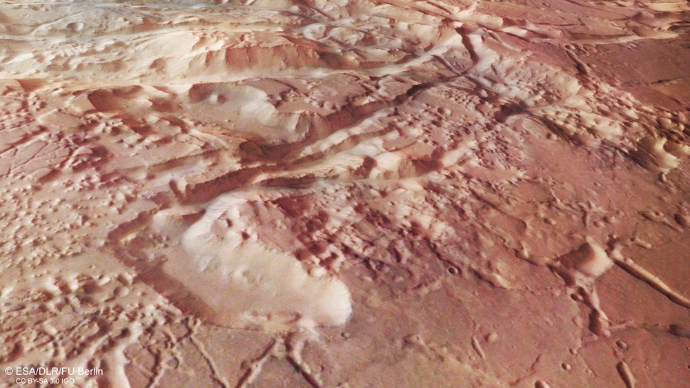
Perspective view of the transition zone between Margaritifer Terra and Aurorae Chaos
At the transition between the Margaritifer Terra highland region and the Aurorae Chaos depression, the plain of the southern highlands is heavily furrowed and characterised by grabens, valleys, hollows and shattered landscape. The crust was torn apart by tensile tectonic forces, while underground ice was probably stored in cavities directly beneath the surface. This thawed due to a heat source – rising magma from a volcano or the heat generated by a nearby asteroid impact – and rose to the surface before flowing north. The resulting cavities collapsed, leaving a landscape that is described as ‘chaotic terrain’ by planetary geologists.
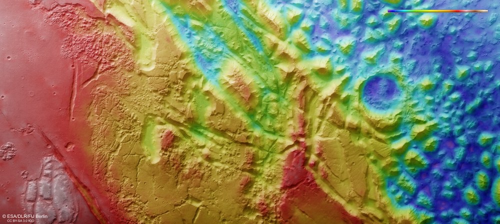
Topographical image map of the southern part of Aurorae Chaos
Image strips acquired from different angles by the HRSC camera system on board Mars Express were used to generate digital terrain models of the Martian surface, containing height information for each recorded pixel. The reference level to which the elevation data refer is an imaginary surface that experiences the same gravitational attraction as that found at sea level on Earth. Known as an equipotential surface, this is shaped like a biaxial ellipsoid and is known as an areoid, a name derived from Ares, the Greek name for Mars. North is to the right. The colour coding of the digital terrain model (legend top right) indicates the differences in elevation. The bottom of the Aurorae Chaos depression (the blue area on the right in the image) lies about 4000 metres below the level of the highlands (red, on the left of the image). The colouration also reveals tectonic fracture structures and their direction. A striking escarpment runs through the middle of the image from northeast to southwest, forming a connection between the high plateau in the south and Aurorae Chaos, which lies thousands of metres lower.
These images, acquired by the HRSC camera on board Mars Express, show the southern part of Aurorae Chaos, a region whose surface collapsed following the melting of large quantities of underground ice.
There are numerous mineralogical indications of the early presence of water in and around Mars' numerous chaotic regions.
The data used to create the images were acquired on 31 October 2018, during Mars Express orbit 18,765. The image resolution is 14 metres per pixel.
Focus: Space, planetary research, Mars
At first glance, it looks like brown crocodile skin photographed at close range, but these images actually show the rough, rugged terrain of Aurorae Chaos. The data used to create the images were acquired by the High Resolution Stereo Camera (HRSC) operated by the German Aerospace Center (Deutsches Zentrum für Luft- und Raumfahrt; DLR) on board ESA’s Mars Express spacecraft, which has been orbiting Mars since 2003.
Aurorae Chaos is one of many areas of 'chaotic terrain' on Mars. Such terrain typically features a random – and thus chaotic – arrangement of table mountains and isolated boulders of various sizes. Aurorae Chaos is located in the highland region of Margaritifer Terra, a few hundred kilometres from the eastern end of the Valles Marineris canyon system. Many of these chaotic areas are found here, near the equator, and at the transition from the southern highlands to the northern lowlands. No geological formations of this type exist on Earth.
There is a morphologically comparable region on Mercury, and some chaotic areas have also been identified on Jupiter's natural satellite Europa, but in both cases, their geological origins are very different to the chaotic areas on Mars. In the case of Europa, the crust is being pulled apart and then compressed again by tidal forces, resulting in complex configurations of broken floes, fissures and ridges. On Mercury, the chaotic areas were caused by seismic movements in the planet's crust following a huge asteroid impact.
A very large chaotic area
Aurorae Chaos is part of an extensive system of fissures, grabens and hills to the northeast of the vast Valles Marineris canyon system. The bottom of the irregularly shaped depression, which measures up to 600 kilometres across, is approximately four kilometres lower than the surrounding plains. The entire chaos region within Margaritifer Terra covers around 1.6 million square kilometres, making it an extremely imposing landscape. Elsewhere on Mars, the chaotic terrains are significantly smaller, barely exceeding the size of an impact crater.
An escarpment runs from northeast to southwest through the centre (images 1, 4 and 5) and connects the high plateau in the south with the lower-lying areas of Aurorae Chaos in the north. The transition zone features fractures and grabens that run parallel with or diagonal to the escarpment. These were caused by tension in the Martian crust due to tectonic forces that stretched and tore apart the brittle crust in this region. In addition, smaller chaos regions can be made out to the south of the escarpment (left in images 1, 4 and 5 ).
Evidence of the complex history of water on Mars
Such chaotic areas bear witness to the complex transport, storage and release of large amounts of water ice and liquid water on Mars in the past.
The theory most widely held by scientists is that chaotic terrain is formed when underground ice reservoirs melt due to heating, suddenly releasing large quantities of water. The heat may have come from nearby volcanoes or been released as the result of major asteroid impacts. Once the water has drained away, the surface collapses into the newly-formed cavities.
Scientists have used crater size and frequency measurements to estimate the age of the bottom of the huge Aurorae Chaos depression at 3.5 billion years. The collapse process occurred a very long time ago. Groundwater and magma may also have escaped during the collapse, in addition to meltwater.
There are numerous mineralogical indications of the early presence of water, which would have flowed in and around Mars' chaotic terrains. Sulphate-containing layers of sediment that have been identified in some of the basins with chaotic structures indicate the formation and accumulation of this mineral due to the evaporation of relatively acidic water. Clay mineral deposits on the plateau areas of Margaritifer Terra, which predate the sulphate-containing deposits, may be related to fissures and groundwater run-off. The formation of clay minerals would have required the presence of standing, pH-neutral water.
Image processing The High Resolution Stereo Camera (HRSC) acquired the data from which these images were created on 31 October 2018 during Mars Express Orbit 18,765. The ground resolution is about 14 metres per pixel and the centre of the imaged area is located at approximately 327 degrees east and 11 degrees south. The colour image was created using data from the nadir channel, the field of view of which is aligned perpendicular to the surface of Mars, and the colour channels of the HRSC. The colour-coded topographic view is based on a Digital Terrain Model (DTM) of the region, from which the topography of the landscape can be derived. The reference body for the HRSC-DTM is a Mars equipotential surface (Areoid). The oblique perspective view was generated from the DTM and data from the nadir and colour channels of HRSC. The anaglyph, which provides a three-dimensional view of the landscape when viewed using red-green or red-blue glasses, was derived from data acquired by the nadir channel and the stereo channels.
The HRSC experiment on Mars Express The High Resolution Stereo Camera was developed by the German Aerospace Center (Deutsches Zentrum für Luft- und Raumfahrt; DLR) and built in collaboration with partners in industry (EADS Astrium, Lewicki Microelectronic GmbH and Jena-Optronik GmbH). The science team, which is headed by Principal Investigator (PI) Ralf Jaumann, consists of 52 co-investigators from 34 institutions in 11 countries. The camera is operated by the DLR Institute of Planetary Research in Berlin-Adlershof.