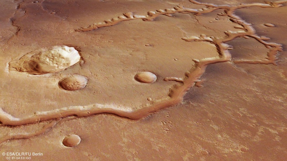
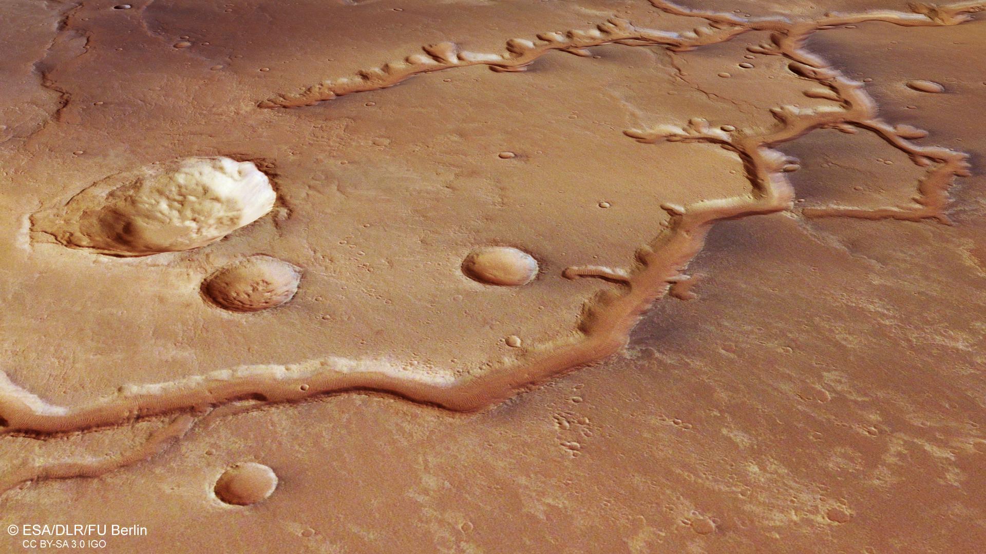
View of the western part of the upper reaches of Nirgal Vallis
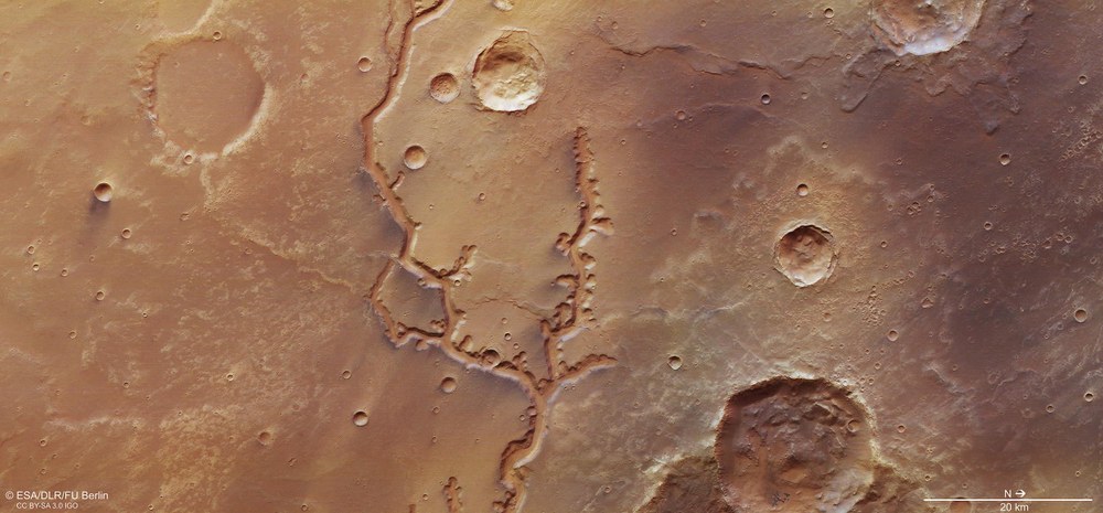
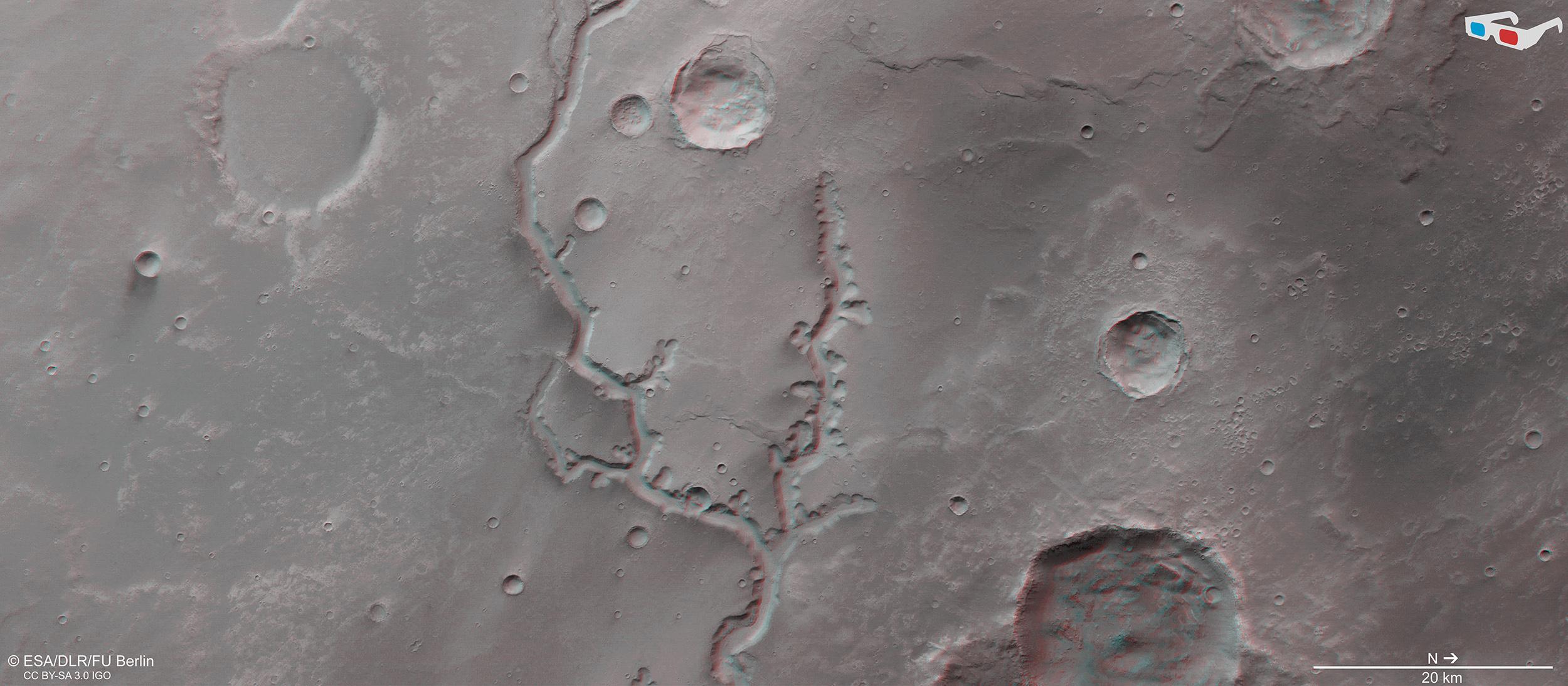
Nirgal Vallis stretches 700 kilometres across the southern Martian Highlands; north is to the right in the image. The shape of the main valley and its remarkably short side valleys is somewhat unusual when compared to the morphology of most river valleys on Earth. The cross section of the valley is a striking U-shape, with very steep scarps several hundred metres high at the sides and a flat, broad valley floor. Particularly striking are the two impact craters that are almost identical in size, but which have eroded in very different ways. These can be seen at the bottom right and upper left edges of the image. Each measures approximately 20 kilometres across. Partially lobular ejecta blankets can be clearly seen around both craters. The highland plain in which Nirgal Vallis was created by the outflow of water consists of solidified, low-viscosity flood basalts.
Nirgal Vallis stretches 700 kilometres across the Southern Highlands of Mars, cutting across ancient lava deposits. This view shows an approximately 75-kilometre-long section in the western part of the upper valley. The U-shaped profile of Nirgal Vallis and its steep slopes (shown to slightly exaggerated effect here), which tower several hundred metres on both sides of the valley, are both very striking. It is also noticeable that the side valleys are comparatively short. They were formed not by the run-off of surface water, but rather by retrograde erosion caused by water seepage from a groundwater horizon below the upper rim of the surrounding terrain. The data used to create the images of this region were acquired by the High Resolution Stereo Camera (HRSC) on 16 November 2018 during Mars Express Orbit 18,818. The image resolution is approximately 14 metres per pixel. This oblique perspective view was generated from a digital terrain model and data from the nadir and colour channels of HRSC.
Anaglyph images can be generated from data acquired by the nadir channel of HRSC, which is oriented vertically onto the surface, and one of the four oblique-view stereo channels. When viewed with red-blue or red-green glasses, these images give a realistic, three-dimensional view of the landscape. North is to the right.
In November 2018 the HRSC camera system operated by DLR on board ESA's Mars Express spacecraft imaged a 75-kilometre section of the western upper reaches of Nirgal Vallis.
A river once flowed here, draining up to 4800 cubic metres of water into Uzboi Vallis each second – more than twice the volume of water that the Rhine delivers into the North Sea in the same amount of time.
The shape of the valley indicates that it may have been formed by seeping groundwater. Melting ground ice is thought to have been the primary source of this groundwater.
Focus: Space, planetary research
These images, created using data acquired by the High Resolution Stereo Camera (HRSC) instrument, show the upper reaches of Nirgal Vallis, a river valley on Mars, which extends over 700 kilometres across the Southern Highlands. In Babylonian mythology, Nirgal is the equivalent of Mars, the Roman god of war.
The shape of the main valley and its remarkably short side valleys is somewhat unusual when compared to the morphology of most river valleys on Earth. The cross section of the valley is a striking U-shape, with very steep scarps several hundred metres high at the sides and a broad, flat valley floor. In November 2018, the ESA Mars Express spacecraft imaged an approximately 75-kilometre-long section of the western part of the upper valley using the HRSC, which is operated by the German Aerospace Center (Deutsches Zentrum für Luft- und Raumfahrt; DLR).
Approximately 400 kilometres further east, Nirgal Vallis flows into the large outflow channel Uzboi Valles, which runs from south to north. Scientists have estimated that the river that once flowed through Nirgal Vallis drained up to 4800 cubic metres of water per second into Uzboi Vallis – more than twice the volume of water that the Rhine delivers into the North Sea in the same amount of time. Many Mars researchers believe that several billion years ago these large, north-flowing masses of water filled the 150-kilometre-wide Holden Crater – which lies to the northeast – with a lake that was up to 250 metres deep.
Nirgal Vallis is the visible remains of this ancient river. However, it is thought that the river did not flow constantly, but sporadically carried large quantities of water. The steep sides and flat bottom of the valley are features that, on Earth, tend to be seen in valleys created by glacial erosion.
Valley morphology has few equivalents on Earth
The short side valleys have the semi-circular or basin-shaped entrances typical of this type of valley. These resemble the circular amphitheatres built by the Romans, and are thus referred to as such. Examples of river valleys of this type can be seen on Earth in the Atacama Desert in Chile, in the Colorado Plateau in the USA and on the islands of Hawaii. In addition to Nirgal Vallis, other well-known examples on Mars include Nanedi Valles. Nirgal Vallis and its side valleys cut across ancient volcanic plains. Traces of former lava flows can be seen in the ridged furrows (centre of Image 1 – between the forked valley branches – and at the top centre right), which were created when these volcanic deposits cooled and thus shrank.
The flat floor of Nirgal Vallis is largely covered by transverse ripples (visible as small parallel lines), which indicate the prevailing wind direction along the course of the valley. A group of small sand dunes can be observed on the floor of the large crater to the north of Nirgal Vallis (lower-centre-right edge of the image). Unlike the transverse ripples, these dunes consist of old volcanic ash, and appear dark and blue-grey in this image.
Nirgal Vallis is similar in shape to valleys on Earth that have been formed by retrograde erosion due to seeping groundwater. This is also suggested by the lack of dendritic side valleys feeding into the main channel. A linear valley structure of this kind is often a sign that the erosion of the valley was not caused by precipitation and surface run-off.
In laboratory experiments, researchers have been able to demonstrate that valleys such as Nirgal Vallis could have been formed by seeping groundwater. The constant seepage of water just below the surface leads to the undermining of the already steep valley entrances and the eventual collapse of the valley walls. On Mars, melting ground ice is thought to have been the primary source of groundwater.
Image processing
Systematic processing of the data acquired by HRSC was carried out at the DLR Institute of Planetary Research. From these data, staff specialising in planetary science and remote sensing at the Freie Universität Berlin produced the images shown here. The image data were acquired by HRSC on 16 November 2018 during Mars Express Orbit 18,818. The image resolution is approximately 14 metres per pixel. The centre of the image is located at approximately 315 degrees east and 27 degrees south. The colour image was created using data from the nadir channel, the field of view of which is aligned perpendicular to the surface of Mars, and the colour channels of the HRSC. The colour-coded topographic view is based on a Digital Terrain Model (DTM) of the region, from which the topography of the landscape can be derived. The reference body for the HRSC-DTM is a Mars equipotential surface (Areoid). The oblique perspective view was generated from the DTM and data from the nadir and colour channels of HRSC. The anaglyph, which provides a three-dimensional view of the landscape when viewed using red-green or red-blue glasses, was derived from data acquired by the nadir channel and the stereo channels.
The High Resolution Stereo Camera was developed by the German Aerospace Center (Deutsches Zentrum für Luft- und Raumfahrt; DLR) and built in collaboration with partners in industry (EADS Astrium, Lewicki Microelectronic GmbH and Jena-Optronik GmbH). The science team, which is headed by Principal Investigator (PI) Ralf Jaumann, consists of 52 co-investigators from 34 institutions in 11 countries. The camera is operated by the DLR Institute of Planetary Research in Berlin-Adlershof.

